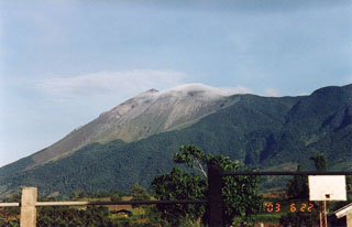
Report on Kanlaon (Philippines) — May 2002
Bulletin of the Global Volcanism Network, vol. 27, no. 5 (May 2002)
Managing Editor: Richard Wunderman.
Kanlaon (Philippines) Increased seismicity during March-April 2002
Please cite this report as:
Global Volcanism Program, 2002. Report on Kanlaon (Philippines) (Wunderman, R., ed.). Bulletin of the Global Volcanism Network, 27:5. Smithsonian Institution. https://doi.org/10.5479/si.GVP.BGVN200205-272020
Kanlaon
Philippines
10.4096°N, 123.13°E; summit elev. 2422 m
All times are local (unless otherwise noted)
In February 2002, the Philippine Institute of Volcanology and Seismology (PHIVOLCS) reported sustained seismic activity that might lead to an explosion at Canlaon. PHIVOLCS noted an increase in seismic activity in Canlaon after five weeks of continuous and sustained earthquakes. During 27-28 February the Guintubdan seismic station detected at least 67 earthquakes, which was above the background seismic level of a few earthquakes per day. PHIVOLCS monitored both high- and low-frequency volcanic earthquakes at Canlaon; high-frequency events dominated, indicating that the volcano was undergoing possible magma intrusion. PHIVOLCS noted that such intrusions result in many high-frequency events intermixed with a few low-frequency earthquakes. The epicenters were detected over a large area, which could mean that a large body of magma was developing beneath the volcano. At this stage of activity, a major eruption was not anticipated because the earthquakes could also have been caused by rockslides along the volcano's faults.
On 27 February trekking was banned within the 4-km danger zone after PHIVOLCS declared Alert Level 1 (the volcano is in a restive state, but trekking or any human activity could be dangerous within the danger zone). PHIVOLCS issued a statement that the area near the volcano should be avoided because of "possible sudden phreatic or steam-driven explosions." In the meantime, monitoring instruments were to be installed at the Guintubdan seismic station, located near the crater, to monitor the volcano's seismic activities.
On 15 April PHIVOLCS concluded that the episodes of apparent seismic unrest at Canlaon could be traced to the Guintubdan and Mambucal areas. The Guintubdan area has been the site of earthquake swarms in the past, and these high-frequency events may be related to local fault movement and/or intrusions. On the other hand, earthquakes in the Mambucal area occurred when the Philippine National Oil Company (PNOC) pumped water into its geothermal wells and induced micro-earthquake fracturing at depth. In both instances, PHIVOLCS noted that significant earthquakes only occurred over a broad area N of the active crater of Canlaon, without distinct clustering or migration towards the crater. These observations suggest that earthquake activity, for now, is not related to a reactivation of the Canlaon magma system. With the return of seismic activity to baseline levels and having identified non-volcanic seismic sources in this area, PHIVOLCS lowered the alert status of Canlaon from Alert Level 1 to Alert level 0. However, visitors to the summit area were strongly urged to avoid entering the crater because sudden explosions may occur without warning. For the same reason, PHIVOLCS reminded the public that no permanent human activity is permitted within 4 km of the crater.
Geological Summary. Kanlaon volcano (also spelled Canlaon) forms the highest point on the Philippine island of Negros. The massive andesitic stratovolcano is covered with fissure-controlled pyroclastic cones and craters, many of which are filled by lakes. The largest debris avalanche known in the Philippines traveled 33 km SW from Kanlaon. The summit contains a 2-km-wide, elongated northern caldera with a crater lake and a smaller but higher active vent, Lugud crater, to the south. Eruptions recorded since 1866 have typically consisted of phreatic explosions of small-to-moderate size that produce minor local ashfall.
Information Contacts: Philippine Institute of Volcanology and Seismology (PHIVOLCS), Department of Science and Technology, 5th & 6th Floors, Hizon building, 29 Quezon Avenue, Quezon City, Philippines.

