Report on Kilauea (United States) — May 2002

Bulletin of the Global Volcanism Network, vol. 27, no. 5 (May 2002)
Managing Editor: Richard Wunderman.
Kilauea (United States) New lava flows during early May burn over 1,000 hectares of forest
Please cite this report as:
Global Volcanism Program, 2002. Report on Kilauea (United States) (Wunderman, R., ed.). Bulletin of the Global Volcanism Network, 27:5. Smithsonian Institution. https://doi.org/10.5479/si.GVP.BGVN200205-332010
Kilauea
United States
19.421°N, 155.287°W; summit elev. 1222 m
All times are local (unless otherwise noted)
Surface activity and seismicity continued at Kīlauea during mid-April through early June 2002. Volcanic tremor was moderate at times and was accompanied by frequent long-period (LP) earthquakes during mid-May. Lava flows erupted during January and April 2002 (figure 154) were fed by several rootless shields located directly above the lava tube at elevations between 2,200 and 2,050 feet. Three significant lava flows began during mid-April and early May (figure 154) and had not yet terminated by the end of the report period. Two of these flows originated in the rootless shield area, and the third broke out from the lava tube system to the SW of Pu`u `O`o crater. The two flows from the rootless shields were the Boundary flow, along the edge of the national park, and the Royal Gardens flow, which approached the uppermost part of Royal Gardens subdivision on 21 May. The Royal Gardens flow entered the subdivision during the night of 22-23 May. From near Pu`u `O`o, the 12 May flow passed along the W side of the flow field and into the forest. The most recent ocean entries at East Kupapa'u and Kamoamoa stopped in mid-January and late January, respectively.
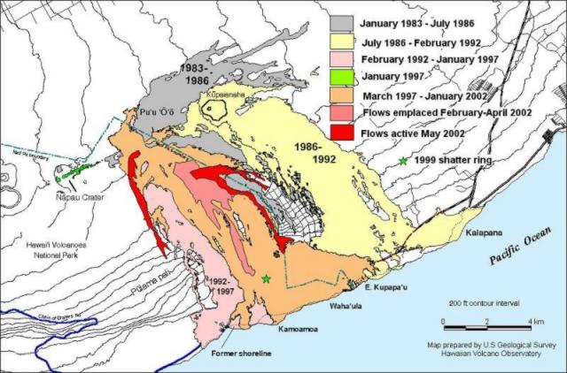 |
Figure 154. A map showing lava flows erupted during the 1983-present activity of Pu'u 'O'o and Kupaianaha craters at Kīlauea. Flows during 1-21 May (shown in black) originated from two sources, the area of the rootless shields and an area just SW of Pu'u 'O'o. Courtesy HVO. |
Geophysical activity. Seismicity was at background levels and tiltmeters showed no significant activity until 23 April, when 10.1 µrad of rapid inflation was recorded at Pu`u `O`o crater. The inflation was inferred to be shallow because other tiltmeters recorded less inflation at greater distance from Pu`u `O`o. The summit showed little accompanying tilt change for this event.
Seismicity and tilt returned to normal levels until 28 April when Pu`u `O`o deflated rapidly and shortly thereafter began again to inflate slowly. Major deflation began on the morning of 12 May, and by 13 May Pu`u `O`o had deflated 18 µrad. Tremor increased to levels above those prior to the deflation and was accompanied by small LP earthquakes at the summit and Pu`u `O`o. Seismicity continued to increase beneath the caldera with one small LP earthquake every ~30 seconds. This swarm ended abruptly on 22 May, and by 24 May seismicity returned to normal background levels with tilt flat or fluctuating slightly. During 5-10 June swarms of frequent LP earthquakes occurred in the caldera accompanied by moderate tremor below Pu`u `O`o, which continued through 15 June.
Lava flows. Observers reported incandescence on 18 April in the East Pond vent and South Wall complex of the Pu`u `O`o crater. Partss of the rootless shield area were also glowing brightly. On a 24 April overflight observers reported a bright glow from the Puka Nui area and a small lava flow from the same area traveling SE. On the same day a lava flow had moved onto the floor of the Pu`u `O`o crater. By 2 May most activity in Pu`u `O`o had subsided to low incandescence.
Around 30 April a bifurcating lava flow originated in the SE corner of the rootless shield; it formed two of three significant flows during May; one occurred along the boundary of Volcano National Park and the other moved towards the Royal Gardens subdivision.
Incandescence waned but the rootless shield flows continued until 12 May when the two large surface flows broke out from the upper tube system near the SW base of Pu`u `O`o. On 12 May at about 1100 a video recording showed that the flows were ~3 m wide and extended an unknown distance downslope. During mid-May activity of the flow along the Park boundary fluctuated on the Pulama pali slope, but all three flows continued. By the end of the report period the 12 May flow was 800-1,000 m from the end of the Chain of Craters road after cascading down part of the 1995 Jason flow (BGVN 20:04). The Royal Gardens flow had advanced into the subdivision and the boundary flow showed dim incandescence and continued its movement along the park boundary.
The 12 May flow ignited fires as it traveled through the wooded areas above the Pulama pali. The fires burned over 1,000 hectares through 1 June and prompted the closure of the Chain of Craters road. By 10 June the fires were 65% contained and the road was reopened for nighttime viewing. No ocean entries occurred during the report period.
Geological Summary. Kilauea overlaps the E flank of the massive Mauna Loa shield volcano in the island of Hawaii. Eruptions are prominent in Polynesian legends; written documentation since 1820 records frequent summit and flank lava flow eruptions interspersed with periods of long-term lava lake activity at Halemaumau crater in the summit caldera until 1924. The 3 x 5 km caldera was formed in several stages about 1,500 years ago and during the 18th century; eruptions have also originated from the lengthy East and Southwest rift zones, which extend to the ocean in both directions. About 90% of the surface of the basaltic shield volcano is formed of lava flows less than about 1,100 years old; 70% of the surface is younger than 600 years. The long-term eruption from the East rift zone between 1983 and 2018 produced lava flows covering more than 100 km2, destroyed hundreds of houses, and added new coastline.
Information Contacts: Hawaiian Volcano Observatory (HVO), U.S. Geological Survey, PO Box 51, Hawaii National Park, HI 96718, USA (URL: https://volcanoes.usgs.gov/observatories/hvo/).