Report on Three Sisters (United States) — June 2002
Bulletin of the Global Volcanism Network, vol. 27, no. 6 (June 2002)
Managing Editor: Richard Wunderman.
Three Sisters (United States) Studies suggest magma slowly accumulating at depth
Please cite this report as:
Global Volcanism Program, 2002. Report on Three Sisters (United States) (Wunderman, R., ed.). Bulletin of the Global Volcanism Network, 27:6. Smithsonian Institution. https://doi.org/10.5479/si.GVP.BGVN200206-322070
Three Sisters
United States
44.133°N, 121.767°W; summit elev. 3159 m
All times are local (unless otherwise noted)
Uplift (up to ~10 cm) occurred during 1996-2000 over a broad region centered 5 km W of South Sister in the Three Sisters region (BGVN 26:05). At the time scientists did not know exactly when the uplift had occurred, whether it would continue, or its specific cause. Although most of these questions remain, some new data are available.
On 18 March 2002 scientists from the USGS Cascades Volcano Observatory and Central Washington University reported that they, in cooperation with staff from the U.S. Forest Service's (USFS) Willamette and Deschutes National Forests, confirmed that slow uplift of the area was continuing at approximately the same rate as previously reported (i.e., a maximum rate of ~2.5 cm/year).
About a month later NASA's Jet Propulsion Laboratory (JPL) released a simulated natural-color image from the Aster high-resolution imaging instrument on the satellite Terra. Aster uses 14 spectral bands, at wavelengths from visible to thermal-infrared, and it has a spatial resolution of 15-90 m. By draping the Aster data over digital topography from the U.S. Geological Survey's National Elevation Dataset, they created a new perspective view of the Three Sisters and adjacent Cascade volcanoes (figure 2). The image was timely because of concerns about continued uplift in the area. BGVN 26:05 included a radar interferogram showing ground uplift pattern during 1996-2000, movement centered ~ 5 km W of South Sister.
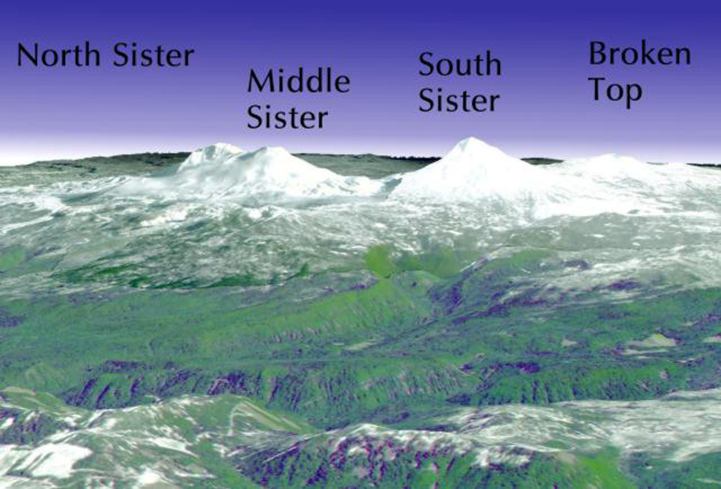 |
Figure 2. The Three Sisters volcanic area appears in this perspective view from the SW quadrant. The view uses a simulated natural-color image from the satellite-borne Aster imaging system, which has been draped over digital topography taken from the U.S. Geological Survey's National Elevation Dataset. N lies to the upper-right; the distance between the summits of North Sister and South Sister is ~ 7 km. The image was released on 12 April 2002. Courtesy NASA's Jet Propulsion Laboratory. |
Analyses of spring water samples collected during late summer 2001 were similar to those from earlier surveys but isotopic studies of carbon and helium in the most recent samples, which were not done previously, suggested a magmatic source. Taken together, the ground deformation, seismic, spring water chemistry, and gas emission results suggest that uplift was caused by slow accumulation of magma at a depth of 6-7 km beneath the surface. If magma intrusion were to continue, it could eventually lead to a volcanic eruption; however, an eruption is unlikely without months to years of precursory activity. In addition to continued or accelerating uplift, precursors to an eruption would include earthquakes, typically swarms of small events generated by fracturing of rock as magma moves upward, and large emissions of volcanic gases, such as carbon dioxide, which is released from the magma.
The Pacific Northwest Seismograph Network (PNSN) has reported three earthquakes in the Three Sisters region since January 2001. On 21 August 2001 a M 1.9 earthquake occurred at a depth of 4.9 km; on 5 November 2001 a M 1 earthquake occurred at a depth of 1 km; and on 18 January 2002 an M 2.4 earthquake occurred at a depth of 3.0 km. The recent earthquakes are consistent with background seismicity at Three Sisters. As of mid-July 2002, the number of earthquakes and gas emissions remained at low-t-obackground levels while steady uplift continued.
General Reference. Scott, W.E., 1987, Holocene rhyodacite eruptions on the flanks of South Sister volcano, Oregon: Geol Soc Amer Spec Pap, v. 212, p. 35-53.
Geological Summary. The north-south-trending Three Sisters volcano group dominates the landscape of the Central Oregon Cascades. All Three Sisters stratovolcanoes ceased activity during the late Pleistocene, but basaltic-to-rhyolitic flank vents erupted during the Holocene, producing both blocky lava flows north of North Sister and rhyolitic lava domes and flows south of South Sister volcano. Glaciers have deeply eroded the Pleistocene andesitic-dacitic North Sister stratovolcano, exposing the volcano's central plug. Construction of the main edifice ceased at about 55,000 yrs ago, but north-flank vents produced blocky lava flows in the McKenzie Pass area as recently as about 1600 years ago. Middle Sister volcano is located only 2 km to the SW and was active largely contemporaneously with South Sister until about 14,000 years ago. South Sister is the highest of the Three Sisters. It was constructed beginning about 50,000 years ago and was capped by a symmetrical summit cinder cone formed about 22,000 years ago. The late Pleistocene or early Holocene Cayuse Crater on the SW flank of Broken Top volcano and other flank vents such as Le Conte Crater on the SW flank of South Sister mark mafic vents that have erupted at considerable distances from South Sister itself, and a chain of dike-fed rhyolitic lava domes and flows at Rock Mesa and Devils Chain south of South Sister erupted about 2000 years ago.
Information Contacts: Cascades Volcano Observatory (CVO), U.S. Geological Survey (USGS), Building 10, Suite 100, 1300 SE Cardinal Court, Vancouver, WA 98683 (URL: https://volcanoes.usgs.gov/observatories/cvo/); Volcano Hazards Team, USGS, 345 Middlefield Road, Menlo Park, CA 94025-3591 USA (URL: http://volcanoes.usgs.gov/); Pacific Northwest Seismograph Network (PNSN), University of Washington Geophysics Program, Box 351650, Seattle, WA 98195-1650 USA (URL: http://www.geophys.washington.edu/SEIS/PNSN/); Jet Propulsion Laboratory, California Institute of Technology, National Aeronautics and Space Administration, Pasadena, CA 91109 (URL: http://www.jpl.nasa.gov/).