Report on Nyamulagira (DR Congo) — July 2002

Bulletin of the Global Volcanism Network, vol. 27, no. 7 (July 2002)
Managing Editor: Richard Wunderman.
Nyamulagira (DR Congo) Eruption began on 25 July and continued through at least early August 2002
Please cite this report as:
Global Volcanism Program, 2002. Report on Nyamulagira (DR Congo) (Wunderman, R., ed.). Bulletin of the Global Volcanism Network, 27:7. Smithsonian Institution. https://doi.org/10.5479/si.GVP.BGVN200207-223020
Nyamulagira
DR Congo
1.408°S, 29.2°E; summit elev. 3058 m
All times are local (unless otherwise noted)
According to news articles, a team of volcanologists from the UN Office for the Coordination of Humanitarian Affairs and the Goma Volcanological Observatory stated that seismicity dramatically increased at Nyamuragira around 25 February 2002. In a statement released to UN headquarters that day, the team of volcanologists said they expected an eruption within the following days or weeks, but that residents near the volcano should not be worried.
On the evening of 25 July an eruption produced a cloud of steam, gas, and ash, 100- to 200-m-high lava fountains, and lava flows down the N and S flanks. Seismic records indicated that the eruption began at about 1310. National Park guards saw "smoke" rising above the volcano about an hour earlier. Scientists who observed the crater later that night from both S (on the E-W road heading to Sake) and E (on the N-S road to Rutchuru at Rumangabo National Park headquarters) at a distance of 20 and 7 km, respectively, saw that the crater had been cut by two fractures: a longer one heading NNE and a smaller one heading SSW on the opposite side of the crater. Sustained 100- to 200-m-high lava fountains were visible along the fracture. One lava flow traveled N from the several-kilometer-long fracture, while a smaller one moved S and stopped on the morning of 26 July, when the lava flows were 6-7 km long and ~1 km wide. Neither of the flows threatened inhabited areas, but did cause large amounts of damage to Park vegetation.
Volcanic clouds produced during the eruption were detected by several satellites. Beginning on 26 July around 0000, a steam-and-ash plume was visible on METEOSAT satellite imagery, below 6 km altitude, drifting to the WSW.
According to Simon Carn, the orbit of the Earth Probe Total Ozone Mapping Spectrometer (EP TOMS) satellite was well-placed over the Nyamuragira region at 1138 on 26 July, and an SO2 cloud associated with this eruption was detected (figure 22). Though contemporaneous SO2 emissions from Nyiragongo could not be ruled out, most of the SO2 was thought to originate from Nyamuragira. Preliminary analysis indicated an SO2 mass of ~125-140 kilotons (kt) in the 26 July cloud, with the highest SO2 concentrations (peaking at ~100 milli atm cm or Dobson Units) recorded in a ~400-km-long and ~300-km-wide segment of the plume extending WSW from the volcano across the DR Congo. SO2 concentrations over the volcano were somewhat lower at ~45 milli atm cm. From the distal end of the ~400-km-long segment, a narrower and less distinct portion of the plume (with SO2 concentrations 30 milli atm cm) extended ~500 km NW. At its farthest extent the plume was ~800 km from Nyamuragira.
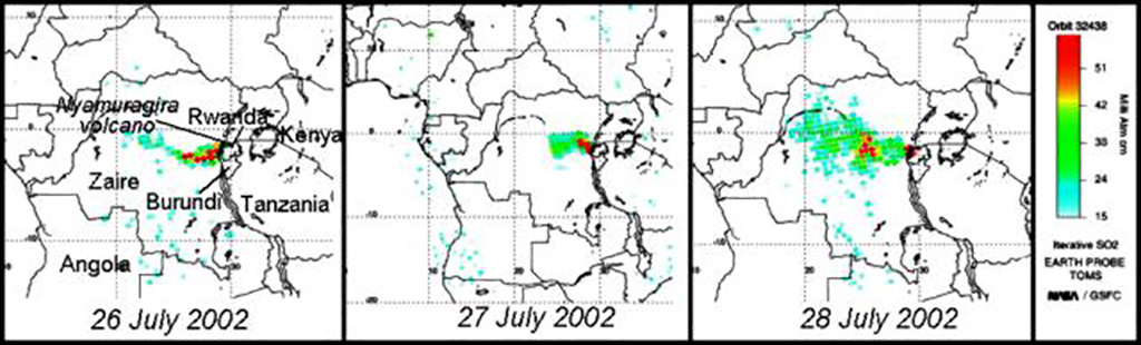 |
Figure 22. SO2 clouds detected on Earth Probe TOMS satellite images during 26-28 July 2002, during the eruption of Nyamuragira. Detectable plumes spread W across southern Africa. Courtesy TOMS Volcanic Emissions Group. |
Earth Probe TOMS did not detect any ash cloud associated with the eruption. At 1050 on 27 July EP TOMS detected ~150 kt of SO2 in a plume extending to the edge of the EP TOMS swath ~500 km W of Nyamuragira (figure 22). The imaged plume was truncated by a data gap at that point, but no SO2 was detected beyond the gap ~600 km farther W. The highest SO2 concentrations (~86 milli atm cm) were recorded immediately W of Nyamuragira. At 1140 on 28 July EP TOMS detected the largest SO2 cloud seen so far during the current activity, containing ~330 kt SO2 in a plume extending unbroken up to ~1,200 km WNW of Nyamuragira (figure 22). At its farthest extent the cloud was ~750 km wide. Continued high SO2 concentrations over Nyamuragira and Nyiragongo (75 milli atm cm) indicated ongoing emissions at the time of the TOMS overpass. A region of elevated SO2 concentrations (~55-58 milli atm cm) was also detected in the cloud ~440 km W of Nyamuragira.
Helicopter flights on 1 and 3 August revealed that the eruption continued at a high rate. Two cones were growing on the eruptive fracture, built by the accumulation of spatter and ash from two very active 100- to 200-m-high lava fountains. Two large lava flows moved quickly and joined below the lowest cone to form a main flow. The main flow (estimated then to be 15 km long) moved NNE and changed direction towards the NE after a few kilometers. Many smaller branching flows were visible on the E side of the main flow. The front of the main flow appeared to be very wide, though it remained within the National Park boundaries. Permanent tremor was registered. The Alert Level remained at Yellow through at least early August.
Geological Summary. Africa's most active volcano, Nyamulagira (also known as Nyamuragira), is a massive high-potassium basaltic shield about 25 km N of Lake Kivu and 13 km NNW of the steep-sided Nyiragongo volcano. The summit is truncated by a small 2 x 2.3 km caldera that has walls up to about 100 m high. Documented eruptions have occurred within the summit caldera, as well as from the numerous flank fissures and cinder cones. A lava lake in the summit crater, active since at least 1921, drained in 1938, at the time of a major flank eruption. Recent lava flows extend down the flanks more than 30 km from the summit as far as Lake Kivu; extensive lava flows from this volcano have covered 1,500 km2 of the western branch of the East African Rift.
Information Contacts: Jacques Durieux and Dario Tedesco, United Nations Office for the Coordination of Humanitarian Affairs (OCHA), United Nations, New York, NY 10017, USA (URL: https://reliefweb.int/); Simon A. Carn, TOMS Volcanic Emissions Group, Joint Center for Earth Systems Technology (NASA/UMBC), University of Maryland Baltimore County, 1000 Hilltop Circle, Baltimore, MD 21250, USA (URL: https://jcet.umbc.edu/); Toulouse Volcanic Ash Advisory Center (VAAC), Météo-France, 42 Avenue Gaspard Coriolis, F-31057 Toulouse cedex, France (URL: http://www.meteo.fr/vaac/); Air Force Weather Agency, Offutt AFB, NE 68113-4039, USA; Associated Press; Reuters.