Report on Suwanosejima (Japan) — July 2002
Bulletin of the Global Volcanism Network, vol. 27, no. 7 (July 2002)
Managing Editor: Richard Wunderman.
Suwanosejima (Japan) Volcanic tremor, plumes, and ash eruptions during October 2001-August 2002
Please cite this report as:
Global Volcanism Program, 2002. Report on Suwanosejima (Japan) (Wunderman, R., ed.). Bulletin of the Global Volcanism Network, 27:7. Smithsonian Institution. https://doi.org/10.5479/si.GVP.BGVN200207-282030
Suwanosejima
Japan
29.638°N, 129.714°E; summit elev. 796 m
All times are local (unless otherwise noted)
The Japanese Meteorological Agency (JMA) reported that, following the latest eruptive activity that had ended on 30 July, an eruption began around 1400 on 11 October 2001 at Otake Crater. Volcanic tremor had started around 1200 on 11 October and continued through 15 October. Up to 11 explosions occurred. An acoustic microphone installed on the island recorded four shock waves associated with larger explosions.
On 18 June 2002 during 1130-1300 a plume was observed (figure 7), and on the morning of 19 August 2002, JMA issued a volcanic advisory for Suwanose-jima. Volcanic tremor events associated with continuous acoustic signals (the largest so far in 2002) occurred for 20- to 30-minute periods around 0000 and 0630, and also during 0940-0950, 1410-1500, 1810-1815, and 1920-1930. Small tremor events also occurred. Witnesses in [the village 4 km SSW of the crater] heard continuous rumblings and explosion sounds every 2-3 seconds. The summit was covered with clouds and abundant ash drifted SW and SE. The summit crater emitted steam to an unknown height. A large plume was seen on satellite imagery on 19 August (figure 8). Eruption clouds were visible on 10, 16, and 20 August 2002 (figure 9).
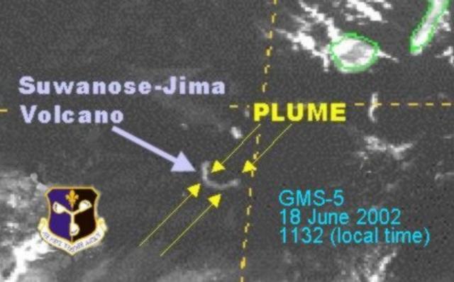 |
Figure 7. Satellite image of the plume from Suwanose-Jima volcano observed at 1132 (local time) on 18 June 2002. The plume was visible from 1130-1300. Courtesy Charles Holliday, AFWA. |
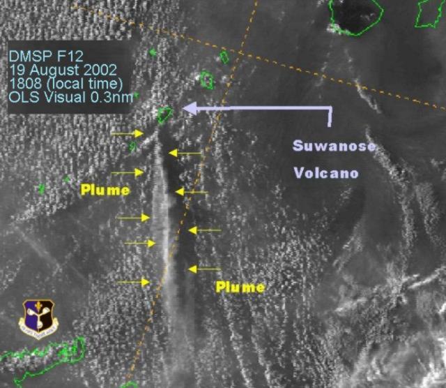 |
Figure 8. Satellite view showing plume emitted from Suwanose-jima on 19 August 2002 at 1808 (local time). Courtesy Charles Holliday, AFWA. |
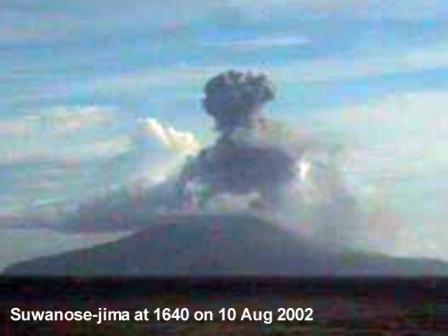 |
Figure 9. Eruption clouds emitted from Suwanose-jima at 1640 on 10 August 2002. The clouds were observed through live camera images provided by the Satellite Image Network Group (SiNG). Courtesy N. Uchida, JMA. |
On 21 and 22 August JMA reported that eruptive activity continued but at a lower level. On 20 August, volcanic tremor events occurred during 0115-0120 and 0625-0655. Witnesses in [the] village reported that the rumbling noises became weaker, though they were sometimes accompanied by large explosion sounds. Ashfall occurred in Naze city on Amami-oshima island (~140 km S) during the afternoon. Faint ashfall was observed ~4 km SSW of the summit on 20 and 21 August.
Observations from the air on 21 August revealed the December 2000 crater (BGVN 26:02) generating an ash cloud to 1.5 km above the crater that was drifting S.
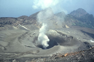
Geological Summary. The 8-km-long island of Suwanosejima in the northern Ryukyu Islands consists of an andesitic stratovolcano with two active summit craters. The summit is truncated by a large breached crater extending to the sea on the E flank that was formed by edifice collapse. One of Japan's most frequently active volcanoes, it was in a state of intermittent Strombolian activity from Otake, the NE summit crater, between 1949 and 1996, after which periods of inactivity lengthened. The largest recorded eruption took place in 1813-14, when thick scoria deposits covered residential areas, and the SW crater produced two lava flows that reached the western coast. At the end of the eruption the summit of Otake collapsed, forming a large debris avalanche and creating an open collapse scarp extending to the eastern coast. The island remained uninhabited for about 70 years after the 1813-1814 eruption. Lava flows reached the eastern coast of the island in 1884. Only about 50 people live on the island.
Information Contacts: N. Uchida, Japanese Meteorological Agency (JMA), 1-3-4 Ote-machi, Chiyoda-ku, Tokyo 100, Japan; Volcano Research Center (VRC), Earthquake Research Institute, University of Tokyo, Yayoi 1-1-1, Bunkyo-ku, Tokyo 113-0032, Japan (URL: http://www.eri.u-tokyo.ac.jp/VRC/index_E.html); Charles Holliday, Air Force Weather Agency (AFWA), Satellite Applications Branch, Offutt AFB, NE 68113-4039; Satellite Image Network Group (SiNG), Faculty of Education, Kagoshima University, Kagoshima 890, Japan.