Report on Pacaya (Guatemala) — July 2002

Bulletin of the Global Volcanism Network, vol. 27, no. 7 (July 2002)
Managing Editor: Richard Wunderman.
Pacaya (Guatemala) Lava lake activity during August 2000-June 2001 marks change in eruptive style
Please cite this report as:
Global Volcanism Program, 2002. Report on Pacaya (Guatemala) (Wunderman, R., ed.). Bulletin of the Global Volcanism Network, 27:7. Smithsonian Institution. https://doi.org/10.5479/si.GVP.BGVN200207-342110
Pacaya
Guatemala
14.382°N, 90.601°W; summit elev. 2569 m
All times are local (unless otherwise noted)
Large explosions occurred from MacKenney Crater on 16 January and 29 February 2000 (BGVN 25:01). Although an increase in SO2 degassing during February and March 2001 was reported (BGVN 26:04), the following provides additional information about activity from February 2000 through January 2002. The Washington VAAC reported that possible low-level ash around the summit was visible on GOES-8 satellite imagery on 30 May 2002.
Activity during March-November 2000. Hotspots on GOES images from the 29 February 2000 eruption were noted until 1 March 2000, after which they shrank until August 2000, although strong SO2 degassing continued at a level of ~1,500-2,000 metric tons/day (t/d).
In August 2000 ash eruptions took place for a week, after which a lava lake appeared in the summit crater during the last week of the month. The lava lake generated occasional booming sounds, ashfall, and the spattering of bombs. These were generally restricted to within MacKenney crater; they originated from an inner crater that was 20 m wide with 25-m-deep walls and ~50 m below the rim.
Gas emission increased to high levels beginning in November 2000, producing dense plumes that affected vegetation near the crater. The vigorous plumes were typically deflected by prevailing winds to the S and W where they damaged pine trees and corn fields in areas between El Caracol and Los Positos, 3 km W and 5.5 km S, respectively.
Activity during February 2001-June 2001. An increase in SO2 degassing during February and early March 2001 coincided with a significant increase in daily tremors (BGVN 26:04). On 22 February a local seismometer recorded >600 tremors/day, up from < 100 tremors/day in earlier weeks. At the same time, gaseous emission had increased from ~253 to ~550 t/d and there was visible magma in the crater. The SO2 flux was measured by COSPEC along the highway from Guatemala to Escuintla on 1, 15, and 28 February and on 8 March. The respective flux values in t/d were 951, 1,740, 1,448, and 1,673. These flux rates suggested that although lava outpouring was almost nonexistent, degassing of SO2 was quite high.
Nighttime incandescence from long-term lava lake activity was easily seen at a distance of several kilometers from August 2000 through June 2001 and was often visible from Guatemala and Escuintla cites (N and S of Pacaya, respectively). This marked a shift in eruptive style from the persistent Strombolian eruptions characteristic of Pacaya for several decades.
Activity during July 2001-November 2001. After June 2001, incandescence was no longer visible, but strong degassing continued, along with seismicity consisting of 250-380 B-type events/day. Erosion of the rim of the outer crater was accompanied by rock avalanches down the S flank of the cone. During September to October 2001 acid rain from the vigorous degassing affected areas to the N of Pacaya and burned leaves on vegetation in the El Cedro, San Francisco de Sales, and San José Calderas areas; residents in these areas reported that some birds had also died. On 31 October minor Strombolian explosions produced a little ash visible on satellite imagery during 1611-1820. A persistent plume reached 50-200 m above the crater, and ash fell S of the volcano. Since that time observers from INSIVUMEH reported only gas emission, and lava lake activity was not seen. On 14 November 2001 SO2 fluxes of 1,800 tons/day were measured at MacKenney Crater by INSIVUMEH.
Activity during January 2002. During field work on 12 January 2002, measurements were made of the active crater on MacKenney cone. Along a N-S transect the crater was 72 m wide at its narrowest point, and 94-100 m at its widest. The pit was ~80 m deep, and was the location of two sources of gas. Activity was characterized by persistent degassing. COSPEC measurements showed that SO2 emission rates remained high, ranging from 500 to more than 2,000 t/d. These rates were similar, but perhaps more variable, than one year earlier.
During 8-14 January 2002 geologists from INSIVUMEH and Michigan Technological University measured SO2 fluxes of ~1,200 tons/day in Pacaya's plumes (figure 33). Volcanologists who spent at night at the observatory reported seeing plume glow, presumably reflected light from a deeper lava source. The degassing produced a thick white plume, similar to that often generated by Masaya volcano in Nicaragua. The plume was seen drifting horizontally S from the crater on 29 January 2002 by volcanologists at the summit of Santa Ana volcano in El Salvador, 120 km E. This sustained level of degassing was in contrast to previous activity, during which the average gas emission rate for the 20-year period of 1973-93 was estimated by Andres and others (1993) to be a comparatively modest 260 t/d.
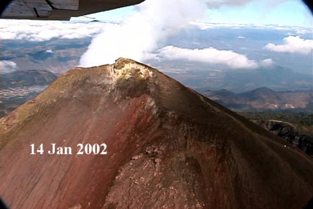 |
Figure 33. Aerial view taken on 14 January 2002 showing the upper part of Pacaya's Mackenney cone from the SE with a white gas plume blowing N. Courtesy of Matt Watson. |
General Reference. Andres, R.J., Rose, W.I., Stoiber, R.E., Williams, S.N., Matias, O., and Morales, R., 1993, A summary of sulfur dioxide emission rate measurements from Guatemalan volcanoes: Bulletin of Volcanology, v. 55, no. 5, p. 379-388.
Geological Summary. Eruptions from Pacaya are frequently visible from Guatemala City, the nation's capital. This complex basaltic volcano was constructed just outside the southern topographic rim of the 14 x 16 km Pleistocene Amatitlán caldera. A cluster of dacitic lava domes occupies the southern caldera floor. The post-caldera Pacaya massif includes the older Pacaya Viejo and Cerro Grande stratovolcanoes and the currently active Mackenney stratovolcano. Collapse of Pacaya Viejo between 600 and 1,500 years ago produced a debris-avalanche deposit that extends 25 km onto the Pacific coastal plain and left an arcuate scarp inside which the modern Pacaya volcano (Mackenney cone) grew. The NW-flank Cerro Chino crater was last active in the 19th century. During the past several decades, activity has consisted of frequent Strombolian eruptions with intermittent lava flow extrusion that has partially filled in the caldera moat and covered the flanks of Mackenney cone, punctuated by occasional larger explosive eruptions that partially destroy the summit.
Information Contacts: Gustavo Chigna and Otoniel Matías, Instituto Nacional de Sismologia, Vulcanologia, Meteorologia e Hydrologia (INSIVUMEH), 7a Av. 14-57, Zona 13, Guatemala City, Guatemala; William Rose, Matt Watson, Janelle Byman, Elly Bunzendahll, Lizzette Rodríguez, Ivonne Branan, and Gregg Bluth, Michigan Technological University, Houghton, MI 49931, USA; Lee Siebert and Paul Kimberly, Global Volcanism Program, Smithsonian Institution, Washington, DC 20560-0119, USA; Andrew Harris, Luke Flynn, Mark Davies, University of Hawaii, 2525 Correa Road, Honolulu, HI 96822, USA; Simon Carn, TOMS Volcanic Emissions Group, Joint Center for Earth Systems Technology (NASA/UMBC), University of Maryland, Baltimore County, 1000 Hilltop Circle, Baltimore, MD 21250, USA.