Report on Kilauea (United States) — August 2002

Bulletin of the Global Volcanism Network, vol. 27, no. 8 (August 2002)
Managing Editor: Richard Wunderman.
Kilauea (United States) Lava flowed over land and poured over the sea cliff during parts of mid-2002
Please cite this report as:
Global Volcanism Program, 2002. Report on Kilauea (United States) (Wunderman, R., ed.). Bulletin of the Global Volcanism Network, 27:8. Smithsonian Institution. https://doi.org/10.5479/si.GVP.BGVN200208-332010
Kilauea
United States
19.421°N, 155.287°W; summit elev. 1222 m
All times are local (unless otherwise noted)
During June through early September 2002 at Kīlauea, seismicity was generally at background levels with the exception of a swarm of long-period (LP) earthquakes and tremor that has been occurring at Kīlauea's crater since 5 June. The swarm increased slightly in late July but decreased in mid-August. On the morning of 18 August, the number of LP earthquakes increased. By late August, seismicity was back to normal levels. The swarm of LP earthquakes and tremor fluctuated but typically remained high. In early September, the swarm that had been occurring since early June returned to moderate-to-low levels. Pu`u `O`o deflated through June and early July, then inflated briefly in late July before remaining essentially unchanged through early September.
Surface lava flows continued from Kīlauea's SW flank; late in July a spectacular show began as lava flowed into the sea. This continued into mid-August, stopped briefly, and resumed in early September.
Geophysical activity. At the start of the report period seismicity was at background levels, except at the Pu`u `O`o crater, where a swarm of LP earthquakes has occurred since 5 June. Moderate tremor took place at Pu`u `O`o in mid-June. In late July, the seismicity swarm increased slightly returning to normal by mid-August. The swarm of LP earthquakes fluctuated through the remainder of August and decreased to moderate-to-low levels by early September.
During 11-12 June, ~2 µrad of deflation was measured at Pu`u `O`o. Overall deflation continued at Pu`u `O`o and Kīlauea's summit during the remainder of June, with 0.9 µrad occurring on 26 June. No significant deformation was detected. Slow deflation was recorded at Pu`u `O`o from 4 July until 6 July, when inflation began to occur. Slow inflation continued until at least 9 July, followed by a period of slow deflation that ended in late July. A brief period of inflation occurred on 26 July. No further signs of significant deformation were observed through the end of August. On 2 September it was observed that Pu`u `O`o was slowly deflating. This was followed by small episodes of inflation and deflation at Uwekahuna and Pu`u `O`o for several days ending on 9 September.
Lava Flows. During June through early July, several surface lava flows (incandescent at times in late June) were often visible at Kīlauea. By 10 July, surface lava flows were visible traveling down the Pulama pali scarp and Paliuli, the steep slope and cliff below Pulama pali and just above the coastal flat. On 20 July at 1900 part of the westernmost lava flow reached the Chain of Craters road, and by 0445 the next day lava was entering the sea in two areas. The active flow front moved 610 m in 18 hours on nearly flat ground (3.6 m/hour), relatively quickly for Kīlauea. During the final week of July, hundreds of spectators flocked to Kīlauea to see the spectacular show of lava flowing into the sea at the end of easily accessible Chain of Craters road. Surface lava flows were observed traveling down Pulama pali, Paliuli, and on the coastal flat.
By 6 August, only the Wilipe`a entry was active, with lava from five or six lava tubes pouring off the bench into the water. The West Highcastle bench was steaming but had no lava. At the Highcastle kipuka, two actively advancing lobes of lava were found, one 160 m and the other 170 m from the western and eastern remnants, respectively, of the Chain of Craters road, themselves only 40-60 m from water. Each lobe was moving very slowly (figure 155).
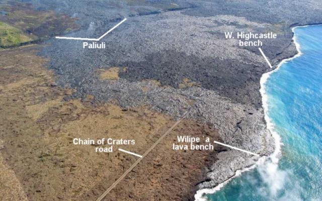 |
Figure 155. Aerial view on 2 August 2002 of Kīlauea's active flow field between Wilipe'a and West Highcastle benches and Paliuli. The new flows are the lightest gray color. The medium-gray color on the left shows the vegetated flows (probably 600-900 years old) and the dark gray shows the 1992-97 flows. View looks NE. Courtesy HVO. |
On 7 August at 1427 the W Highcastle lobe reached the sea. On the evening of the 7th littoral explosions on the E side of the most seaward tip of the lava bench sprayed spatter and solid rocks back onto the bench. A lava bench began to grow near the W Highcastle flow 10 m from the shoreline; it was 30 m long and parallel to the sea cliff by 11 August. Surface lava flows also cascaded down Paliuli at times (figure 156).
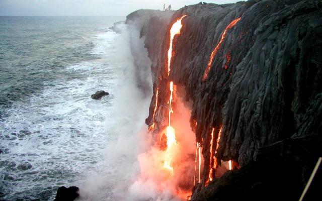 |
Figure 156. View of the western group of lava falls at Highcastle entry, taken at 0557 on 10 August 2002. Sense of scale is provided by the people standing near the sea cliff to the left (W) of the flowing lava. Courtesy HVO. |
Lava flows sporadically entered the sea during mid-August, traveling to the coast through lava tubes and over the surface. On the morning of the 18th several people witnessed part of a lava bench collapse into the sea. On 21 August lava entered near the Highcastle stairs (the more easterly ocean entry), but by the 25th no lava was entering the sea. During late August and early September, lava continued to flow SE down Paliuli and Pulama pali, and many surface lava flows were visible on the coastal flat. Lava began to enter the ocean again on 3 September.
Geological Summary. Kilauea overlaps the E flank of the massive Mauna Loa shield volcano in the island of Hawaii. Eruptions are prominent in Polynesian legends; written documentation since 1820 records frequent summit and flank lava flow eruptions interspersed with periods of long-term lava lake activity at Halemaumau crater in the summit caldera until 1924. The 3 x 5 km caldera was formed in several stages about 1,500 years ago and during the 18th century; eruptions have also originated from the lengthy East and Southwest rift zones, which extend to the ocean in both directions. About 90% of the surface of the basaltic shield volcano is formed of lava flows less than about 1,100 years old; 70% of the surface is younger than 600 years. The long-term eruption from the East rift zone between 1983 and 2018 produced lava flows covering more than 100 km2, destroyed hundreds of houses, and added new coastline.
Information Contacts: Hawaiian Volcano Observatory (HVO), U.S. Geological Survey, PO Box 51, Hawaii National Park, HI 96718, USA (URL: https://volcanoes.usgs.gov/observatories/hvo/).