Report on San Cristobal (Nicaragua) — August 2002

Bulletin of the Global Volcanism Network, vol. 27, no. 8 (August 2002)
Managing Editor: Richard Wunderman.
San Cristobal (Nicaragua) Tremor increases during late May 2002, activity continues in August
Please cite this report as:
Global Volcanism Program, 2002. Report on San Cristobal (Nicaragua) (Wunderman, R., ed.). Bulletin of the Global Volcanism Network, 27:8. Smithsonian Institution. https://doi.org/10.5479/si.GVP.BGVN200208-344020
San Cristobal
Nicaragua
12.702°N, 87.004°W; summit elev. 1745 m
All times are local (unless otherwise noted)
Activity at San Cristóbal during November 2001-May 2002 included strong [gas] emissions on 23 May (BGVN 27:04). At the time, no other phenomena were observed that could indicate an increase in the eruptive activity of the volcano. Volcanic tremor began to increase at San Cristóbal on 28 May, reaching a peak of ~150 RSAM units around noon the next day (figure 12). The summit of the volcano was not visible, but satellite imagery from the Centro de Vigilancia de Ceniza Volcánica revealed that ash was emitted from the volcano. After the 29th, the amount of tremor began to decrease. Incandescence was visible at the crater rim on 1 June. By 3 June tremor was still relatively high.
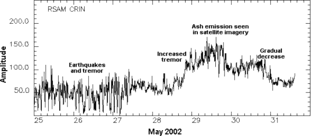 |
Figure 12. Seismicity at San Cristóbal as measured by RSAM (y-axis, arbitrary RSAM units) during 25-31 May 2002. Courtesy INETER. |
A ground observer in Chinandega, Nicaragua indicated that San Cristóbal was active on 21 August around 1600. Ash was not visible on an INETER volcano camera at 1630 due to dense cloud cover. A possible plume was detected on satellite imagery taken at 1545 during a break in the cloud cover; it was estimated to be near summit level and drifting W. The volcano remained at Alert Level Orange.
Geological Summary. The San Cristóbal volcanic complex, consisting of five principal volcanic edifices, forms the NW end of the Marrabios Range. The symmetrical 1745-m-high youngest cone, named San Cristóbal (also known as El Viejo), is Nicaragua's highest volcano and is capped by a 500 x 600 m wide crater. El Chonco, with several flank lava domes, is located 4 km W of San Cristóbal; it and the eroded Moyotepe volcano, 4 km NE of San Cristóbal, are of Pleistocene age. Volcán Casita, containing an elongated summit crater, lies immediately east of San Cristóbal and was the site of a catastrophic landslide and lahar in 1998. The Plio-Pleistocene La Pelona caldera is located at the eastern end of the complex. Historical eruptions from San Cristóbal, consisting of small-to-moderate explosive activity, have been reported since the 16th century. Some other 16th-century eruptions attributed to Casita volcano are uncertain and may pertain to other Marrabios Range volcanoes.
Information Contacts: Wilfried Strauch, Director General de Geofísica, Instituto Nicaragúüense de Estudios Territoriales (INETER), P.O. Box 1761, Managua, Nicaragua (URL: http://www.ineter.gob.ni/); Washington Volcanic Ash Advisory Center (VAAC), Satellite Analysis Branch, NOAA/NESDIS/E/SP23, NOAA Science Center Room 401, Camp Springs, MD 20746, USA (URL: http://www.ssd.noaa.gov/); La Prensa (URL: http://www.laprensa.com.ni/).