Report on Izu-Torishima (Japan) — October 2002
Bulletin of the Global Volcanism Network, vol. 27, no. 10 (October 2002)
Managing Editor: Richard Wunderman.
Izu-Torishima (Japan) Mid-August 2002 plumes, larger crater, and discolored water
Please cite this report as:
Global Volcanism Program, 2002. Report on Izu-Torishima (Japan) (Wunderman, R., ed.). Bulletin of the Global Volcanism Network, 27:10. Smithsonian Institution. https://doi.org/10.5479/si.GVP.BGVN200210-284090
Izu-Torishima
Japan
30.484°N, 140.303°E; summit elev. 394 m
All times are local (unless otherwise noted)
Following ship-based reports of activity at Tori-shima on 11 August 2002, scientists from the Japanese Meterological Agency overflew the area the next day when they observed and photographed ash plumes being erupted from the crater (BGVN 27:07). According to the Japan Coast Guard (via JMA), the activity continued as of 1200 on 14 August; the plume reached ~1.2-1.5 km above sea level on 13 August (figure 3), and ~900 m on 14 August. Emissions were observed from three active areas along the western inner-wall of the summit crater. The crater appeared to have widened. By 21 August, the Japan Coast Guard reported that Izu-Tori-shima no longer "smoked" and only weak steaming was seen in the southern portion of the crater. Faintly discolored sea surface was observed around the island.
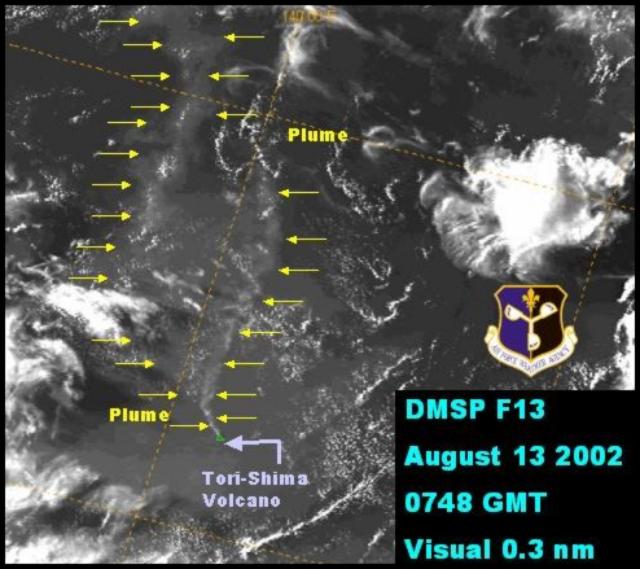 |
Figure 3. Izu-Tori-Shima plume on 13 August 2002. Courtesy Air Force Weather Agency. |
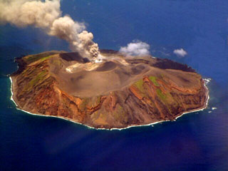
Geological Summary. The circular, 2.7-km-wide island of Izu-Torishima in the southern Izu Islands is capped by an unvegetated summit cone formed during an eruption in 1939. Fresh lava flows from this eruption form part of the northern coastline of the basaltic-to-dacitic edifice. The volcano is referred to as Izu-Torishima to distinguish it from the several other Japanese island volcanoes called Torishima ("Bird Island"). The main cone is truncated by a 1.5-km-wide caldera that contains two central cones, of which Ioyama is the highest. Historical eruptions have also occurred from flank vents near the north coast and offshore submarine vents. A submarine caldera 6-8 km wide lies immediately to the north.
Information Contacts: Tomonori Kannno and Hitoshi Yamasato, Japanese Meteorological Agency (JMA), Volcanological Division, 1-3-4 Ote-machi, Chiyoda-ku, Tokyo 100, Japan (URL: http://www.jma.go.jp/); Volcano Research Center (VRC), Earthquake Research Institute (ERI), University of Tokyo (URL: http://www.eri.u-tokyo.ac.jp/VRC/index_E.html); U.S. Air Force Weather Agency, Offutt AFB, NE 68113-4039, USA.