Report on Miyakejima (Japan) — November 2002
Bulletin of the Global Volcanism Network, vol. 27, no. 11 (November 2002)
Managing Editor: Richard Wunderman.
Miyakejima (Japan) High SO2 fluxes, minor ash eruptions continue through November 2002
Please cite this report as:
Global Volcanism Program, 2002. Report on Miyakejima (Japan) (Wunderman, R., ed.). Bulletin of the Global Volcanism Network, 27:11. Smithsonian Institution. https://doi.org/10.5479/si.GVP.BGVN200211-284040
Miyakejima
Japan
34.094°N, 139.526°E; summit elev. 775 m
All times are local (unless otherwise noted)
Volcanic activity that began at Miyake-jima during June and July 2000 was still ongoing as of November 2002. The current activity included a large amount of discharging volcanic gas. SO2 flux remained high (about 5,000-10,000 tons/day) as of October 2002. All residents of Miyake-jima island have been evacuated since September 2000.
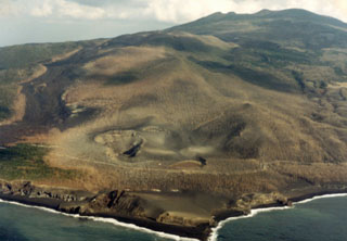
During the 2000 activity, for several weeks the crater expanded in both depth and diameter (BGVN 25:09) and by September 2000 its diameter reached ~1.6 km. As of November 2002, the crater diameter remained at ~1.6 km. Several phreatomagmatic eruptions had occurred during July and August 2000 (e.g., July 14-15; August 10, 13, 18, and 29). The largest eruption occurred on 18 August 2000 (BGVN 25:09). It produced an eruption column to a height of ~15 km. Large amounts of ash and bombs ejected, the latter frequently rich in juvenile material and in a cauliflower shape (figure 16). About 30-40% of the ash consisted of juvenile fragments containing many micro-bubbles and microlites (figure 16).
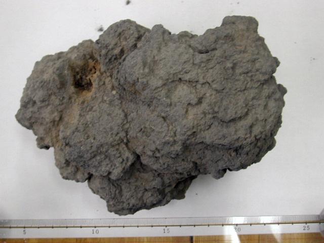 |
Figure 16. Cauliflower-shaped bomb from the 18 August 2000 eruption of Miyake-jima. Courtesy GSJ. |
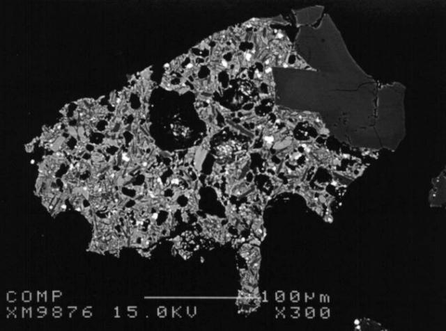 |
Figure 17. A polished section of 18 August 2000 ash showing a 100 µm scale bar. The specimen is riddled with microlites and sub-circular micro-bubbles. Courtesy GSJ. |
During the 29 August 2000 eruption (BGVN 25:07), a low-temperature pyroclastic flow occurred. The flow was weak, however, it reached the sea and sent an ash cloud to 8.0 km. Following the largest eruption on 18 August 2000, a large amount of volcanic gas, especially SO2, began to discharge. The mean flux during September-December 2000 was ~40,000 tons/day.
Table 2 compiles recent minor eruptions during 2001-2002. A major eruption had not occurred at Miyake-jima since 29 August 2000. However, small explosions with minor ash emission sometimes occurred. As of 15 November 2002, the last such explosion was on 8 October 2002.
Table 2. Occasional small, typically ash-bearing explosions took place at Miyake-jima during January 2001 through 15 November 2002. All of the eruptions since 2001 were small with minor ash emission; however, some plume observations following outbursts were thwarted by weather or other limitations (situations indicated by question marks). In several cases, the ash columns rose to heights of 1 to 1.5 km above the crater rim. Data from JMA and provided courtesy GSJ.
| Date | Time (approximate) | Plume height above rim |
| 11 Jan 2001 | 1040 | 800 m |
| 19 Mar 2001 | 0700-0740 | 800 m |
| 27 May 2001 | 0604 | 1,200 m |
| 03 Jun 2001 | 0634 | 700 m |
| 10 Jun 2001 | 1925 | 500 m |
| 10 Jun 2001 | 0638 and 0823 | 500 m |
| 18 Jul 2001 | 1742 | ?? |
| 26 Sep 2001 | 1132 | 1,000 m |
| 27 Sep 2001 | 2128 | 1,000 m |
| 27 Sep 2001 | 2304 | 800 m |
| 28 Sep 2001 | 0528 | 800 m |
| 11 Oct 2001 | 0445 and 0900 | ?? |
| 16 Oct 2001 | 0722 | 1,500 m |
| 01 Nov 2001 | 1232 | 800 m |
| 23 Jan 2002 | 1234 | 200 m |
| 21 Feb 2002 | 1737 | 300 m |
| 02 Mar 2002 | 0553 and 0612 | ?? |
| 31 Mar 2002 | 0604 | 200 m |
| 02 Apr 2002 | 1002 | 300 m |
| 16 Apr 2002 | 0600 | ?? |
| 15 Jun 2002 | 1619 | 500 m |
| 01 Aug 2002 | 1742 | ?? |
| 16 Sep 2002 | 0510 | ?? |
| 08 Oct 2002 | 1451 | 200 m |
Satellite imagery on 5-6 August showed a plume from Miyake-jima drifting ~185 km (100 nautical miles; figure 18). A wind profile taken at a nearby Hachijo-jima island was used to infer that the plume was below ~1,500 m.
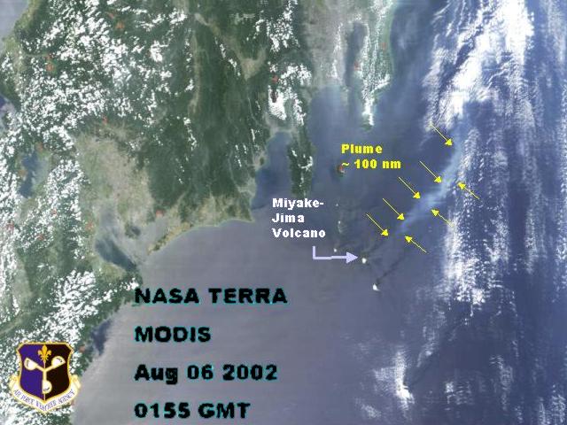 |
Figure 18. Satellite imagery on 6 August 2002 showed a plume drifting to the ENE from Miyake-jima. Courtesy Charles Holliday, U.S. AFWA. |
Geological Summary. The circular, 8-km-wide island of Miyakejima forms a low-angle stratovolcano that rises about 1,100 m from the sea floor in the northern Izu Islands about 200 km SSW of Tokyo. The basaltic volcano is truncated by small summit calderas, one of which, 3.5 km wide, was formed during a major eruption about 2,500 years ago. Numerous craters and vents, including maars near the coast and radially oriented fissure vents, are present on the flanks. Frequent eruptions have been recorded since 1085 CE at vents ranging from the summit to below sea level, causing much damage on this small populated island. After a three-century-long hiatus ending in 1469 CE, activity has been dominated by flank fissure eruptions sometimes accompanied by minor summit eruptions. A 1.6-km-wide summit crater was slowly formed by subsidence during an eruption in 2000.
Information Contacts: Akihiko Tomiya, Geological Survey of Japan (GSJ), National Institute of Advanced Industrial Science and Technology (AIST), Tsukuba Central 7, Tsukuba 305-8567, Japan (URL: http://staff.aist.go.jp/a.tomiya/miyakeE.html); Japan Meteorological Agency (JMA), Volcanological Division, 1-3-4 Ote-machi, Chiyoda-ku, Tokyo 100, Japan (URL: http://www.jma.go.jp/); Charles Holliday, U.S. Air Force Weather Agency (AFWA),106 Peacekeeper Dr., Ste 2NE; Offutt AFB, NE 68113-4039 USA.