Report on Kilauea (United States) — November 2002

Bulletin of the Global Volcanism Network, vol. 27, no. 11 (November 2002)
Managing Editor: Richard Wunderman.
Kilauea (United States) Inflation-deflation episodes and lava flows through 2 December 2002
Please cite this report as:
Global Volcanism Program, 2002. Report on Kilauea (United States) (Wunderman, R., ed.). Bulletin of the Global Volcanism Network, 27:11. Smithsonian Institution. https://doi.org/10.5479/si.GVP.BGVN200211-332010
Kilauea
United States
19.421°N, 155.287°W; summit elev. 1222 m
All times are local (unless otherwise noted)
Surface activity and seismicity continued at Kīlauea during mid-September through early December 2002. At times lava was visible flowing on the coastal flat, and farther upslope on steep slopes and cliffs (at Paliuli, a steep zone just above the coastal flat, and Pulama Pali, a larger steep zone farther upslope). Seismicity was generally at normal levels. There were short periods of inflation and deflation at Uwekahuna and Pu`u `O`o.
Lava flows. During 11-30 September, lava continued to travel SE down Pulama pali and Paliuli, and many surface lava flows were visible on the coastal flat. Lava flowed onto the Wilipe'a bench directly seaward of the end of the Chain of Craters Road. Lava entered the sea at several points on the NE portion of the front of the bench. A great, elongate tumulus was forming directly above the buried pavement of the Chain of Craters Road, near the end of the exposed pavement. On 16 September, it was 3-5 m high, very steep sided, and elongate along the direction of the old road. Also on 16 September, two flows on either side of the West Highcastle lobe threatened to enter the sea. Both flows sent lava onto an old bench. One flow was more or less along the W edge of the West Highcastle lobe, and the other was split into two fingers near the old sea cliff forming the back side of the old bench; one finger was along the E side of the West Highcastle lobe, and the other midway between the Highcastle and West Highcastle lobes. The two flows were fed by the burgeoning West Highcastle lobe, supplied mainly by lava coming over the eastern part of Paliuli. On 22 September, the Highcastle and West Highcastle lobes of the Mother's Day flows were filled in by active lava. A new delta (bench) was being built seaward of the 1995 delta; on 22 September, the new addition was about 20 m beyond the old coastline. During late September visitors saw several sudden collapses of the front of the bench. Lava entered the sea at several points along the two active lava deltas (Middle Highcastle and Wilipe`a) during 1-23 October. No surface flows were visible on the deltas; lava either entered the water via lava tubes or inflated the delta underneath the surface. Several surface flows were visible on the coastal flat, and sporadically on Paliuli and Pulama pali. During late October and early November, surface lava flows were not visible on the coastal flat, but were occasionally seen near Paliuli and Pulama pali. Similar activity continued through mid-November, when spots of incandescence were visible on Paliuli, on the gentle slope below Pulama pali, and above Pulama pali.
From 21 November through 2 December lava continued to flow into the ocean at low-to-moderate levels at the West Highcastle and Wilipe`a entries. West Highcastle was the more active of the two lava deltas, with sporadic explosions coming from one of its entry points. Several surface lava flows were visible on the coastal flat (figure 157).
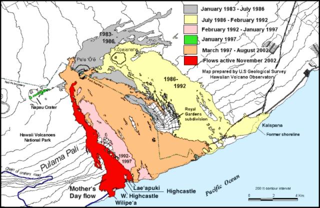 |
Figure 157. Map of lava flows erupted during 1983 through 25 November 2002 from Pu`u `O`o and Kupaianaha. Lava renewed draining into the sea at the Wilipe`a ocean entry on 3 September, and continued as of 25 November. Lavas also renewed draining into the sea at the West Highcastle entry during 16-17 September; they died away during the night of 18-19 September, but returned soon thereafter to continue through at least 25 November. The E arm of the Mother's Day flow branched from Highcastle lobe in late October. After that, this arm of lava sent three fingers into the ocean: at Highcastle on 15 November, at West Lae`apuki on 19 November, and at Lae`apuki on 20 November. Of these, only Lae`apuki (the eastern of the two entries labeled "Lae`apuki") was still active on 25 November, but it had stopped by 29 November. Courtesy HVO. |
Geophysical activity. During mid-September seismicity was generally at normal levels. There were short periods of inflation and deflation at Uwekahuna and Pu`u `O`o. For several days before 18 September, there was a period of repetitive inflation and deflation at Uwekahuna and Pu`u `O`o. After the 18th no significant deformation was recorded. The swarm of long-period earthquakes and tremor beneath Kīlauea's caldera that originally began in June was fairly weak.
On 3 October the swarm of long-period earthquakes and tremor picked up strongly, with numerous long-period events persisting for about a day. Elsewhere there was no unusual seismicity. Around the time of increased seismicity, small periods of inflation and deflation occurred at Pu`u `O`o and Uwekahuna. Otherwise, tiltmeters recorded no unusual deformation.
Small swarms of long-period earthquakes and tremor occurred beneath the caldera during mid-October through at least 2 December. Periods of deflation and inflation continued to occur at Pu`u `O`o and Uwekahuna. A small deflation event began on 28 October that was recorded at the Uwekahuna and Pu`u `O`o tiltmeters. Small deflation may have occurred at the Uwekahuna and Pu`u `O`o tiltmeters on 10 November. Gentle deflation occurred at Pu`u `O`o during 13-24 November.
Geological Summary. Kilauea overlaps the E flank of the massive Mauna Loa shield volcano in the island of Hawaii. Eruptions are prominent in Polynesian legends; written documentation since 1820 records frequent summit and flank lava flow eruptions interspersed with periods of long-term lava lake activity at Halemaumau crater in the summit caldera until 1924. The 3 x 5 km caldera was formed in several stages about 1,500 years ago and during the 18th century; eruptions have also originated from the lengthy East and Southwest rift zones, which extend to the ocean in both directions. About 90% of the surface of the basaltic shield volcano is formed of lava flows less than about 1,100 years old; 70% of the surface is younger than 600 years. The long-term eruption from the East rift zone between 1983 and 2018 produced lava flows covering more than 100 km2, destroyed hundreds of houses, and added new coastline.
Information Contacts: Hawaiian Volcano Observatory (HVO), U.S. Geological Survey, PO Box 51, Hawaii National Park, HI 96718, USA (URL: https://volcanoes.usgs.gov/observatories/hvo/).