Report on McDonald Islands (Australia) — December 2002
Bulletin of the Global Volcanism Network, vol. 27, no. 12 (December 2002)
Managing Editor: Richard Wunderman.
McDonald Islands (Australia) Significant morphological changes due to eruptive activity
Please cite this report as:
Global Volcanism Program, 2002. Report on McDonald Islands (Australia) (Wunderman, R., ed.). Bulletin of the Global Volcanism Network, 27:12. Smithsonian Institution. https://doi.org/10.5479/si.GVP.BGVN200212-234011
McDonald Islands
Australia
53.03°S, 72.6°E; summit elev. 230 m
All times are local (unless otherwise noted)
Accounts from ship-based observers and satellite imagery have revealed significant morphological changes to McDonald Island due to volcanic activity prior to 6 November 2001. A comparison of November 2001 satellite imagery with 1980 aerial photographs was described in AUSGEO News 68 (December 2002). Tourist reports were published in the Australian Antarctic Division's Antarctic Non-government Activity News (ANAN), no. 89 (January 2003). Geoscience Australia's National Mapping reports the elevation of McDonald Island as 230 m, but the activity described below has most likely increased this value.
A photograph taken on 9 November 2000 (BGVN 26:02) was similar to previous photos and descriptions. In addition, thermal alerts for nearby Heard Island occurred frequently in November and December 2000, an indication not only of eruptive activity there, but clear weather during which any significant activity at McDonald would likely have been detected in infrared satellite imagery. Combined, these observations place the eruptive activity after 9 November 2000, and probably after 30 December 2000.
Analysis of 6 November 2001 satellite imagery. A routine check of Australia's maritime boundaries in the Southern Ocean by Geoscience Australia showed that the McDonald Islands had doubled in size, and it appears that the separate islands of McDonald Island and Flat Island are now one. Geoscience Australia's Bill Hirst was comparing an aerial photograph of the McDonald Islands taken on 11 March 1980, with satellite imagery from Landsat 7 EGM data acquired on 6 November 2001, when he noticed that the islands had changed shape (figure 6). The islands earlier combined area of 1.13 km2 is now thought to have changed to 2.45 km2. Some features have disappeared.
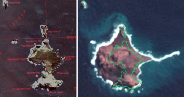 |
Figure 6. Aerial photograph of the McDonald Islands taken on 11 March 1980 from a helicopter (left) and satellite imagery from Landsat 7 EGM data acquired on 6 November 2001 (right). The outline of the islands in 1980 is superimposed on the satellite image. Courtesy of Geoscience Australia. |
The senior surveyor onshore during a 6-day visit in 1980 was Geoscience Australia's John Manning, who named many features of the McDonald Islands. He noted that "Thelander Point doesn't appear to be an appropriate name now, Williams Bay seems to be filled in, and The Needle may be gone . . . Windward Point is no longer a point because there are about 400 m of new land in front of it. The tumultuous bay I called Cauldron is now full of rock, and Flat Island is probably joined to McDonald Island by a shingle comprising gravel and pumice." Other new features appear to be a volcanic hill and a spit to the E of the island similar to one on Heard Island. Macaroni Hill was once the highest point.
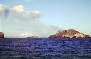
Observations in late November 2002. Experienced observers noted changes to the McDonald Island group in late November 2002 from on board the Akademic Shokalskiy, which was visiting the Heard Island region on a voyage organized by the New Zealand-based tour company Heritage Expeditions. A comparison of old and new photographs of the area shows that the N part of the island is much higher than before, and 75% of the land area that is now there may be completely new. During the last five years Australian national program vessels that have observed the McDonald group have reported seeing steam issuing from vents at various locations.
Three of the passengers on the Akademic Shokalskiy had worked on Heard Island in the 1950's and 1960's, and one of them, Graham Budd, was one of the first two people to set foot on McDonald Island, in 1971. When the ship was travelling towards Heard Island en route from Crozet early on the morning of 26 November, Budd noticed the changed profile of the McDonald islands and expedition leader Rodney Russ decided to take a closer look after the end of the visit to Heard Island. It was not possible to sail too close to the islands because the water around them is uncharted. Under Australian management plans for McDonald Island, landings cannot be made there without a permit and only then for "compelling scientific reasons."
On the second sail past the island, passengers observed steaming slopes and "two types of lava dome." The highest part of the islands was now at the N end, not in the S at Maxwell Hill as it had been previously. Analysis of enlarged digital photographs taken by passengers indicates that considerable sedimentation has occurred along the coastline, such that the formerly separate Flat Island is now joined to the main island. It also appears that several meters of ash have blanketed the N half of McDonald Island, and Macaroni Hill at its N end has disappeared. A low-lying spit and reef now extend over 1 km E of McDonald Island.
Although it is not certain when the activity occurred, wildlife did not appear to have been affected. Penguins were still nesting up to the top of Maxwell Hill and on ash-covered remnants of the old land inshore of the new spit. The birds appear to have deserted Flat Island. There were a large number of penguins and seals on the beaches, and several dozen fur seals swimming offshore.
The two geologists on the voyage, Australian Jon Stephenson and New Zealander Margaret Bradshaw, believe that a scientific visit should be made so that the sequence of the new volcanic events and the composition of the lavas can be determined. The Australian national program currently plans to conduct a scientific program on Heard Island during the 2003-04 austral summer, but currently has no plans to do land-based research on McDonald Island.
MODVOLC Thermal Alerts. Following the distribution of the above reports via the Volcano Listserv, David Rothery and Diego Coppola (The Open University) searched for "thermal alerts" at McDonald Island using the MODIS Thermal Alerts website (http://modis.higp.hawaii.edu/). This system is the first truly global high-temperature thermal monitoring system. It is capable of detecting and documenting changes in active lava flows, lav domes, lava lakes, strongly incandescent vents, and hot pyroclastic flows. No alert is likely to be triggered by an ash cloud.
As described by Flynn et al. (2001) and Wright et al. (2002), the MODIS Thermal Alerts website provides a series of maps updated every 24 hours to show "thermal alerts" based on night-time (approximately 2230 local time) infrared data from a 1-km-resolution instrument called MODIS that is carried by NASA's Terra and Aqua satellites. Thermal alerts are based on an "alert ratio" (3.9 µm radiance - 12 µm radiance) / (3.9 µm radiance + 12 µm radiance), and an alert is triggered whenever this ratio has a value more positive than -0.8. This threshold value was chosen empirically by inspection of images containing known volcanic sites at high temperature, and is the most negative value that avoids numerous false alarms. There are also some daytime (approximately 1030 local time) alerts that are based on the same algorithm but incorporating a correction for estimated solar reflection and a more stringent threshold whereby the alert ratio is required to be more positive than -0.6 in order to trigger an alert.
Thermal alert data are available for the region including McDonald Island from 13 May 2000 onwards (with a gap 26 May-2 June 2000). No thermal alert occurred at McDonald Island from 13 May 2000 through 30 January 2003. This null result does not prove that the activity must have occurred before 13 May 2000, because MODIS cannot see through cloud, which is common in that region. However, there were multiple thermal alerts for nearby Heard Island during the same period (24 May; 3, 5, and 6 June; 25 September; 29 October; 5, 15, 19, and 24 November; 16, 17, 26, and 30 December 2000; 2 February 2001). Had McDonald been active on the same dates, it is highly likely that this activity would have been detected at least once.
Climate and Biology. The following is taken from the AUSGEO News report. The McDonald Islands are remote, and people have landed on the islands only twice since a British sealer sighted them in November 1833. The islands have cliff-lined coasts and are surrounded by rocky shoals and reefs that are treacherous for boats and landing parties. They lie in stormy seas where temperate water from the Indian Ocean meets icy Antarctic water. Most days are cloudy, making it very difficult to obtain satellite imagery and photographs of the islands. Maximum temperatures average 3°C, and wind gusts can reach 210 km/hour. Two Australian scientists looking for fur seals made the first landing in 1970, a 20-minute visit, by helicopter from the French Antarctic ship Gallieni. The second landing, in March 1980, was from the Cape Pillar, chartered by National Mapping to survey the Heard Island-Kerguelen region. The small shore party, which included a botanist, biologist, geologist, and surveyor, landed by helicopter and amphibious vehicle. They stayed ashore for six days while the ship sailed its survey lines.
The McDonald Islands were designated a World Heritage site in December 1997 because of their pristine sub-Antarctic ecosystems and geological activity. Local waters are teaming with Patagonian toothfish, Mackerel icefish, Grey rockcod, and Unicorn icefish. Colonies of Macaroni and Gentoo penguins breed and feed from these islands.
References. Flynn, L.P., Wright R., Garbeil, H., Harris, A.J.L., and Pilger, E., 2001, A global thermal alert system using MODIS: initial results from 2000-2001: Advances in Environmental Monitoring and Modelling, no. 3, Monitoring volcanic hotspots using thermal remote sensing, edited by Harris, A.J.L., Wooster, M.J. and Rothery, D. A. (Http://www.kcl.ac.uk/ kis/schools/hums/geog/advemm/vol1no3.html).
Wright, R., Flynn, L., Garbeil, H., Harris, A., and Pilger, E., 2002, Automated volcanic eruption detection using MODIS: Remote Sensing of Environment, v. 82, p. 135-155.
Geological Summary. Historical eruptions have greatly modified the morphology of the McDonald Islands, located on the Kerguelen Plateau about 75 km W of Heard Island. The largest island, McDonald, is composed of a layered phonolitic tuff plateau cut by phonolitic dikes and lava domes. A possible nearby active submarine center was inferred from phonolitic pumice that washed up on Heard Island in 1992. Volcanic plumes were observed in December 1996 and January 1997 from McDonald Island. During March 1997 the crew of a vessel that sailed near the island noted vigorous steaming from a vent on the N side of the island along with possible pyroclastic deposits and lava flows. A satellite image taken in November 2001 showed the island to have more than doubled in area since previous reported observations in November 2000. The high point of the island group had shifted to the McDonald's N end, which had merged with Flat Island.
Information Contacts: Bruce Hull, Senior Environment Officer, Environmental Management & Audit Unit, Australian Antarctic Division, Environment Australia, Channel Highway, Kingston, Tasmania 7050, Australia (URL: http://www.antarctica.gov.au/environment); AUSGEO News and National Mapping, Geoscience Australia, GPO Box 378, Canberra, ACT 2601, Australia (URL: http://www.ga.gov.au/); David A. Rothery and Diego Coppola, Department of Earth Sciences, The Open University, Milton Keynes MK 6AA, United Kingdom.