Report on Ambrym (Vanuatu) — December 2002
Bulletin of the Global Volcanism Network, vol. 27, no. 12 (December 2002)
Managing Editor: Richard Wunderman.
Ambrym (Vanuatu) Lava lakes remain active in Mbwelesu and Benbow craters through December 2002
Please cite this report as:
Global Volcanism Program, 2002. Report on Ambrym (Vanuatu) (Wunderman, R., ed.). Bulletin of the Global Volcanism Network, 27:12. Smithsonian Institution. https://doi.org/10.5479/si.GVP.BGVN200212-257040
Ambrym
Vanuatu
16.25°S, 168.12°E; summit elev. 1334 m
All times are local (unless otherwise noted)
Observations of Ambrym were made by John Seach during a climb to the caldera during 11-15 December 2002. Lava lakes were visible in both Mbwelesu and Benbow craters that had been absent during a visit in February 2000 (BGVN 25:02) . Reports from local guides indicated that two lava lakes appeared in Mbwelesu crater during February 2001 and joined to form a single lava lake in August 2001. A lava lake reappeared in Benbow crater during June 2002. During November 2002 acid rain, for the third consecutive year, destroyed the mango crops between Sanesup and Lalinda on the W coast of Ambrym.
Activity at Mbwelesu Crater, 12 December 2002. Perfect visibility into the crater enabled detailed observations of the lava lake over 5 hours from the S side of the crater at an elevation of 950 m and over 300 m above the lava lake. The lava lake, located at the bottom of Mbwelesu Crater inside a circular pit (figures 6 and 7), had a diameter of 40-50 m, was in constant motion, and made continuous loud crashing sounds like waves at the beach. The lava lake was much more active than during previous visits in 1998 and 1999. Pele's hair littered the observation area, and white lithic blocks up to 30 cm in diameter were scattered on the rim.
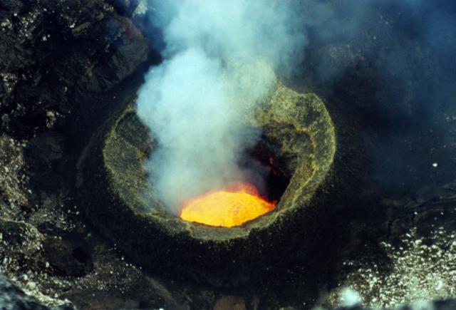 |
Figure 6. Photo of the lava lake inside a circular pit within Mbwelesu Crater at Ambrym, 12 December 2002. The diameter of the lava lake is 40-50 m. Courtesy of John Seach. |
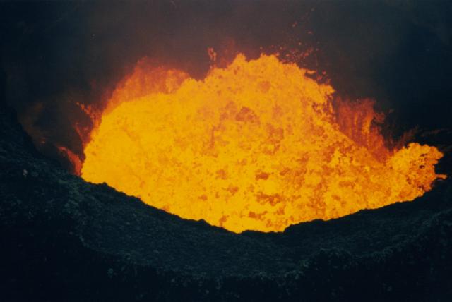 |
Figure 7. Photo showing the violent degassing from the lava lake in Mbwelesu Crater at Ambrym, 12 December 2002. Courtesy of John Seach. |
The surface of the lava lake was continuously disrupted by degassing. Bubbles caused the lake surface to blister and finally burst, splashing lava into the air. Up to eight large bubbles formed at any one time and covered over 80% of the lake surface. The cycle of bubble formation and rupture took about 3 seconds. Waves up to 10 m high formed due to the degassing and crashed onto the side of the pit. After lava waves hit the side of the pit there was a drain-back of lava into the main lake much like ocean waves receding off a beach. Jets of lava were regularly expelled from the lake surface and directed both vertically and at an angle towards the pit side. Fountains reached up to 40 m high. Blobs of molten lava spattered onto the side of the pit up to 20 m from the lava lake edge. This spatter was more erratic than lava fountains and sprayed over a greater area. When large amounts of lava were thrown onto the pit wall, some would cascade back into the lake via a lava stream, lava fall, or a wide curtain of orange flowing lava.
Crusting of the surface was observed when parts of the lake had a lower level of activity, most often in the NE part of the pit opposite the area of most vigorous degassing. Sometimes a lava fountain would burst through the crust, throwing darker pieces of lava high into the air. At times the orange lava lake surface was covered with black pieces of broken crust. Crusting lasted for only a few minutes at a time before it was disrupted by fountains or waves. Lava disappeared into the lava lake surface by subducting under layers of other lava. Some lava disappeared into overhangs on the side of the pit. Lava lake activity continued out of view for an unknown distance past these overhangs.
The lava lake level rose and fell over a period of less than an hour in response to changes in the surface degassing rate. When the rate of degassing was high the lake level was raised by 10 m. The changes appeared to be caused by inflation of the lake due to gas rather than any change in lava eruption rate. During a period of low lava lake activity, the whole lake surface tilted 5 m towards the N and then back to the S over a two-second period. Violent intra-crater winds were observed around the lava lake as reflected in their effects on gas emissions. These were also felt beside the lava lake in Benbow crater. Vapors emitted from the lake surface were white tinged with blue.
Two 15-m-diameter vents 100 m N of the lava lake and 60 m higher were separated by a thin wall. The W vent did not show any activity. The E vent made almost continuous loud degassing noises, and larger explosions ejected black ash 50 m into the air. Mbwelesu was approached again on 15 December, but rain the previous day and low clouds had filled the crater with white vapor, allowing only brief views of the still constantly active lava lake.
Activity at Mbogon Niri Mbwelesu, 12 December 2002. This small collapse pit has been re-named (formerly Niri Mbwelesu Taten) after a request by local residents. The new name comes from the local Port Vato language of W Ambrym, as did the previous name, but is more culturally appropriate. The translation of the new name is " mouth of the wild young pig" (Mbogon = mouth, Niri = son, Mbwelesu = wild pig).
On 12 December excellent visibility enabled detailed observations into Mbogon Niri Mbwelesu. Observations were made from the N side of the pit. Loud crashing, degassing sounds were heard inside the pit, and a 10-m-diameter vent was observed on the floor about 180 m below. The pit glowed bright orange, but lava was not directly observed. This was the first time in 2002 that guides had observed the presence of lava in this pit. Loud degassing occurred every few seconds, and the larger explosions were accompanied by light brown emissions and ground shaking. Pungent sulfurous fumes were emitted from the pit, forcing the observer to use a respirator at times. Strong degassing of brown vapors was coming from the E side of the pit, 50 m below the rim. The W inside wall of the pit was coated with red and yellow deposits.
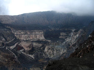
Activity at Niri Mbwelesu Crater, 12 December 2002. On 12 December excellent views were obtained into Niri Mbwelesu. A recent large landslide on the W wall of the crater had covered the previously lava-filled vent. Rockfalls were heard regularly inside the crater and degassing occurred about every 30 seconds. About every 20 minutes larger explosions were heard at the crater; some were audible over 3 km away.
Activity at Benbow Crater, 13 December 2002. Benbow was climbed from the S on 13 December. The observer free-climbed 165 m down to the floor of the first level, and then another 45 m further down to the edge of the lava lake pit in the N of the crater. Inside Benbow there were two active pits. The larger pit, in the middle of the crater, contained a crusted lava lake and two active vents. The SW vent was 25 m in diameter and was full of vapor but emitted no sounds. The NW vent was 10 m in diameter, glowed red, and loudly degassed. The N crater in Benbow contained an active lava lake. The observer climbed to the rim and was able to view the lake surface, ~50 m below, for a few seconds before retreating. The lava lake was in constant motion and lava was ejected in to the air. Violent winds (over 80 km/hour) were generated inside the pit and made observations on the edge dangerous. At times the pit was filled with white and blue-tinged vapors which made breathing difficult. The lava lake made continuous rumbling and sloshing noises. On a wall next to the lava lake pit there was dripping water with a pH of 3.5 and 700 ppm total dissolved solids.
Visit to Ambrym, 15-20 August 2001. Jeff and Raine Williams, sailing aboard the S/Y Gryphon, visited Ambrym Island during 15-20 August 2001. One day was spent hiking to the Mbwelesu crater with a guide from the village of Ranvetlam. Their report has been reduced here to basic observations; a more poetic and complete description of their hike can be found on their website. After leaving Ranvetlam, they began a steep climb through jungle and gardens, continuing through coconut groves and thick woods of breadfruit trees and wild nut trees. After an hour they were still passing through the garden plots of villagers. At higher altitudes the vegetation changed to bananas, kava, and lap-lap plants; wild tree ferns and palm trees were abundant.
After about 90 minutes they emerged from the jungle onto a lava flow at the lower limit of the high central 'ash plain' plateau. They climbed along this "50-yard wide, black gravel road," also described as a "wild orchid-lined highway," through the jungle to the ash plain itself, where the tops of Marum and Benbow could be seen shrouded in clouds and mist. The hike continued across ~1.5 km of the ash plain before passing along a lava gully onto the final ridge, a 1-m-wide path of loose cinders and stone. They climbed to the rim and looked down the sheer, nearly vertical cliffs into the crater, where they heard rumbling and splashing sounds of the active lava lake. Although the weather was cold and windy, the fog cleared enough for the visitors to briefly observe bright red lava in the crater three times within 30 minutes. The 11-km-long hike to the crater took four hours, and another 3 hours to return.
Geological Summary. Ambrym, a large basaltic volcano with a 12-km-wide caldera, is one of the most active volcanoes of the New Hebrides Arc. A thick, almost exclusively pyroclastic sequence, initially dacitic then basaltic, overlies lava flows of a pre-caldera shield volcano. The caldera was formed during a major Plinian eruption with dacitic pyroclastic flows about 1,900 years ago. Post-caldera eruptions, primarily from Marum and Benbow cones, have partially filled the caldera floor and produced lava flows that ponded on the floor or overflowed through gaps in the caldera rim. Post-caldera eruptions have also formed a series of scoria cones and maars along a fissure system oriented ENE-WSW. Eruptions have apparently occurred almost yearly during historical time from cones within the caldera or from flank vents. However, from 1850 to 1950, reporting was mostly limited to extra-caldera eruptions that would have affected local populations.
Information Contacts: John Seach, PO Box 16, Chatsworth Island, NSW, 2469, Australia (URL: http://www.volcanolive.com/); Jeff and Raine Williams, P.O. Box 729, Funkstown, MD 21734, USA.