Report on Lamington (Papua New Guinea) — January 2003
Bulletin of the Global Volcanism Network, vol. 28, no. 1 (January 2003)
Managing Editor: Edward Venzke.
Lamington (Papua New Guinea) Rumors of volcanism in April 2002 were false
Please cite this report as:
Global Volcanism Program, 2003. Report on Lamington (Papua New Guinea) (Venzke, E., ed.). Bulletin of the Global Volcanism Network, 28:1. Smithsonian Institution. https://doi.org/10.5479/si.GVP.BGVN200301-253010
Lamington
Papua New Guinea
8.95°S, 148.15°E; summit elev. 1680 m
All times are local (unless otherwise noted)
During most of April 2002, residents of Popondetta Town, ~21 km NNE of Lamington, and villages near the volcano were besieged by rumors of the volcano showing signs of renewed activity. Later investigations found no evidence of volcanism. Some of the rumors included fire and "smoke" from the volcano, felt earthquakes, and noises. As a result of the rumors, a couple of schools closed, some residents buried their belongings for safekeeping, and others prepared to evacuate. At the time it was difficult for the Rabaul Volcano Observatory (RVO) to confirm or deny the reports because the monitoring equipment for Lamington had not been operating since October 2001.
Based on information from Geoscience Australia and satellite imagery, the Darwin VAAC reported that an E-drifting ash cloud from Lamington seemed to be evident on satellite imagery on 22 April at 1711. The height of the cloud was not known due to thunderstorms in the area making it difficult to detect ash. However, on 23 April at 1105 a flight service reported that no volcanic activity was evident at Lamington. By 26 April Darwin VAAC had concluded that the suspicious cloud was not related to volcanism.
Investigations by the Geological Survey of PNG (RVO and PMGO) of the Department of Mining were carried out during 21-25 April (courtesy of funding from AusAID). On 28 April 2002, RVO reported that, after 3-4 weeks of rumor and speculation suggesting Lamington was showing signs of renewed volcanic activity, none had occurred. Monitoring equipment was restored during the trip, and seismic recordings during those few days showed no seismicity. A very brief aerial inspection of the summit area showed no concrete evidence of renewed volcanic activity. There were no changes in the topographical features or vegetation to indicate recent activity. Small amounts of vapor were being emitted from a few fumarole locations, but that activity was not a new development. There have been no additional reports of unusual activity or increased seismicity through February 2003.
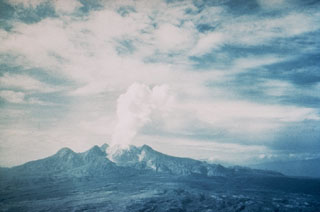
Geological Summary. Lamington is an andesitic stratovolcano with a 1.3-km-wide breached summit crater containing a lava dome that rises above the coastal plain of the Papuan Peninsula of New Guinea north of the Owen Stanley Range. A summit complex of lava domes and crater remnants tops a low-angle base of volcaniclastic deposits dissected by radial valleys. A prominent broad "avalanche valley" extends northward from the breached crater. Ash layers from two early Holocene eruptions have been identified. In 1951 a powerful explosive eruption produced pyroclastic flows and surges that swept all sides of the volcano, killing nearly 3,000 people. The eruption concluded with growth of a 560-m-high lava dome in the summit crater.
Information Contacts: Ima Itikarai, Rabaul Volcano Observatory (RVO), P.O. Box 386, Rabaul, Papua New Guinea.