Report on Bagana (Papua New Guinea) — January 2003

Bulletin of the Global Volcanism Network, vol. 28, no. 1 (January 2003)
Managing Editor: Edward Venzke.
Bagana (Papua New Guinea) Infrared data show nearly continuous activity during 2001-2002
Please cite this report as:
Global Volcanism Program, 2003. Report on Bagana (Papua New Guinea) (Venzke, E., ed.). Bulletin of the Global Volcanism Network, 28:1. Smithsonian Institution. https://doi.org/10.5479/si.GVP.BGVN200301-255020
Bagana
Papua New Guinea
6.137°S, 155.196°E; summit elev. 1855 m
All times are local (unless otherwise noted)
Throughout 2001 and 2002, MODIS detected quasi-continuous thermal alerts at Bagana (figure 1). The most recent report is from August 1995 (BGVN 20:08). The MODIS data are presented here as valuable objective evidence of more recent activity. MODIS thermal alerts were recorded on 16 September, 3, 19, and 26 November, and 10, 12, 28, and 30 December 2000. The 2001-2002 MODIS anomalies were relatively stable with an average alert ratio of -0.63 and generally they consisted of 1 or 2 alert pixels. The maximum alert ratio detected (-0.51) occurred on 21 November 2002 when the number of alert-pixels was at its two-year maximum of 5. This is likely to indicate a higher degree of activity than usual, in which case it is likely to represent effusion of a new lava flow or a pyroclastic flow in the act of emplacement. Coordinates of alert pixels generally clustered tightly around the summit, with a slight preference towards the NW (figure 2). Activity may be genuinely concentrated on this part of the cone, but another explanation would be a 300-m error in the supposed location of the summit relative to the MODIS geocoding. However, the 5-pixel alert of 21 November 2002 is strung out towards the E, which is likely to represent an eastward-flowing lava (or pyroclastic) flow ~2 km long.
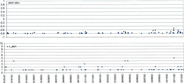 |
Figure 1. MODIS thermal alerts on Bagana during 2001-2002. Courtesy of Diego Coppola and David Rothery, The Open University. |
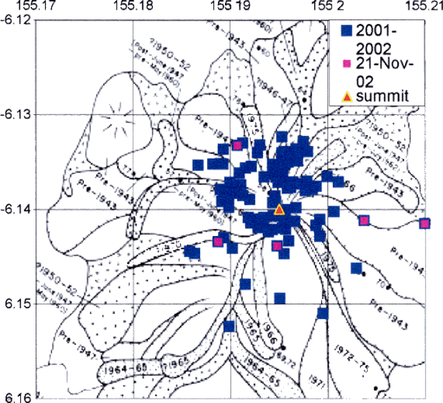 |
Figure 2. Locations of MODIS alert-pixels on Bagana during 2001-2002. Courtesy of Diego Coppola and David Rothery, The Open University. |
Geological Summary. Bagana volcano, in a remote portion of central Bougainville Island, is frequently active. This massive symmetrical cone was largely constructed by an accumulation of viscous andesitic lava flows. The entire edifice could have been constructed in about 300 years at its present rate of lava production. Eruptive activity is characterized by non-explosive effusion of viscous lava that maintains a small lava dome in the summit crater, although occasional explosive activity produces pyroclastic flows. Lava flows with tongue-shaped lobes up to 50 m thick and prominent levees descend the flanks on all sides.
Information Contacts: Diego Coppola and David A. Rothery, Department of Earth Sciences, The Open University, Milton Keynes, MK7 6AA, United Kingdom.