Report on Ambrym (Vanuatu) — January 2003
Bulletin of the Global Volcanism Network, vol. 28, no. 1 (January 2003)
Managing Editor: Edward Venzke.
Ambrym (Vanuatu) Infrared data indicate continued lava lake activity during 2001-2002
Please cite this report as:
Global Volcanism Program, 2003. Report on Ambrym (Vanuatu) (Venzke, E., ed.). Bulletin of the Global Volcanism Network, 28:1. Smithsonian Institution. https://doi.org/10.5479/si.GVP.BGVN200301-257040
Ambrym
Vanuatu
16.25°S, 168.12°E; summit elev. 1334 m
All times are local (unless otherwise noted)
Although the current period of activity at Ambrym has been ongoing since June 1996, direct observations have been intermittent. Most recently, there have been reports of visits during January and February 2000 (BGVN 25:02 and 25:04), August-October 2000 (BGVN 26:02), and August 2001 and December 2002 (BGVN 27:12). Another report of scientific investigations from July 2000 is presented below. These observations are supplemented by MODIS data that indicate continued lava lake activity through much of 2001 and 2002.
Observations during July 2000. During 8-11 July 2000, David Nakedau and Douglas Charley reached Ambrym and camped in the caldera, after the necessary authorizations from local chiefs. On 11 July, French and Italian scientists joined the group. During the following days two stations were installed, one close to the village of Lalinda, the other on the E flank of Benbow cone. The first station, composed of a broadband STS2 seismometer, was installed on a basaltic lava flow with the aim of recording local volcano-related seismicity and tectonic earthquakes. The summit station was equipped with a short-period Mark seismometer to record the activity of the lava lake that used to be visible at Benbow until 1999 and now has drained back at a greater depth due to the Ms 7.1 earthquake of 26 November 1999. The first results from the analysis of these data are currently in press (Carniel and others, 2003).
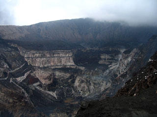
On 11 July 2000 a visit was made to the Niri Taten Mbwelesu crater, where only fumarolic activity could be observed. The crater name means "the son of the female pig," given after its birth in 1989 near the existing Mbwelesu (the pig) and Niri Mbwelesu (the female pig). At the request of local residents, this crater was renamed Mbogon Niri Mbwelesu in December 2002 (BGVN 27:12). After more than a day of continuous rain, on 13 July the installation of the station on the Benbow rim was accomplished. During 13 July strong degassing noises were heard only sporadically from the Southern crater, which was otherwise showing low degassing rates and low-level noises. The southern crater has been observed since the first visits of Douglas Charley, and was the site where the lava lake was observed until 1999. The Northern crater, on the contrary, was not observed by Charley before 1997. Another small vent used to be present on its W side, but was completely buried by 1999 collapses. During 13 July, from the rim observations, this crater appeared to be the source of the strongest noises.
During the following days, two descents were made into Benbow using ropes, one on 14 July by Carniel and Fulle with local guides Jimmy and Isaac; the other was made on 16 July by Charley, Garaebiti, Wallez, and Jimmy. The Southern, older crater, was obstructed and conical in shape. From it's central part, significant blueish-colored degassing was observed, indicating sulfur dioxide. On 14 July visible degassing activity was not accompanied by noticeable sound. On 16 July some small explosions were observed at this vent, which ejected centimeter-sized fragments. On the N side, a fault full of sulfur deposits was visible. Numerous concentric faults were also visible around the vent on the n, E, and W sides. A significant zone of fumarolic activity was concentrated on the N flank of the vent, mainly composed of water vapor. Other small fumaroles were located around the vent. A number of pits were aligned in the W and S border, with the most significant fumarolic activity at the S side, where blueish sulfurous gas escaped continuously.
The Northern crater emitted significant water vapor plumes. To the N and to the S of the vent, two deep tracks were created by water runoff during strong rainfalls. To the E, the border of the vent was formed by rock debris, which, according to the guide Jimmy, was emplaced as a consequence of the strong 26 November 1999 earthquake. Both on 14 July and on 16 July the sound from the N crater appeared to be much lower than from the S crater, an observation opposite to the one made from the Benbow rim on 13 July. On 14 July scientists observed several more dense water vapor clouds, some of them accompanied by the fall of very small (less than 1 cm) light lithic fragments.
Marum, and the surrounding vents of Mbwelesu, Niri Mbwelesu, and Niri Taten Mbwelesu, were visited again on 16 July. Mbwelesu was intensely degassing, which often precluded direct observation of the crater. On the SE side, where a lava lake used to be, only a static mud pond could be seen. Also Taten Mbwelesu crater was showing intense degassing accompanied by strong noise, which made observation difficult. Niri Taten Mbwelesu showed intense degassing but no noise. The dropping of rocks into the pit confirmed the presence of a mud pond at the bottom, at an approximate depth of 200 m.
On 17 July the scientists left the volcano for the village of Lalinda, where they met with the custom chief and the population in order to inform them about the activity of the volcano and about the research. On the early morning of 19 July the two eruptive plumes from Ambrym's main cones were clearly visible at a distance from the island of Paama. However, only the plume produced by Marum was colored pink-orange; this observation suggests the presence of lava at shallow depth in one of its vents, although such a feature was not observed directly during the previous days.
MODVOLC Thermal Alerts, 2001-2002. MODIS detected quasi-continuous thermal alerts for Ambrym throughout 2001 and 2002 (figure 8). Moreover, these occur fairly equally in two clusters interpreted as representing Benbow and Marum (figure 9). These data provide strong evidence in favor of continued lava lake activity. The highest alert ratios for the period of -0.107 on 9 April 2001 in Marum and -0.116 on 3 November 2001 in Benbow may represent episodes of overturn. Marum appears to have been particularly active also during January-February 2002 when the anomaly usually consisted of either 4 or 6 alert-pixels (figure 9). Anomalies continued in January-February 2003.
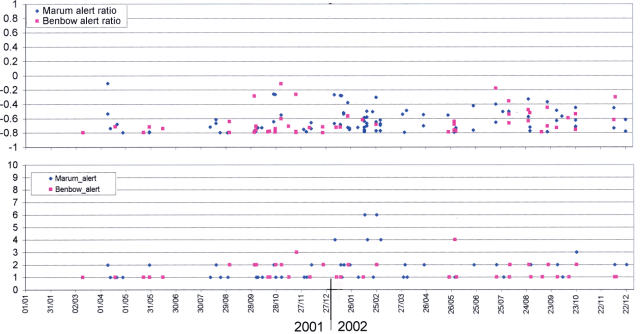 |
Figure 8. MODIS thermal alerts on Ambrym during 2001-2002. Courtesy of Diego Coppola and David Rothery, The Open University. |
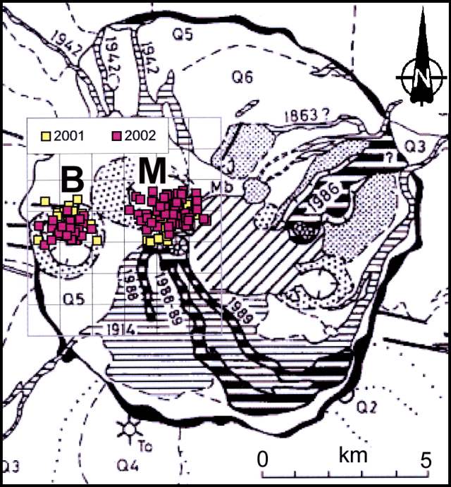 |
Figure 9. Locations of alert-pixels on Ambrym during 2001-2002. The intracaldera craters are Benbow (B) and Marum (M). The base map is not independently geolocated, so the alert-pixel overlay has been migrated to place the two clusters over the likely active craters. Base map is from SEAN 14:04, modified from geological (New Hebrides Geological Survey, 1976) and pedomorphological (Quantin, 1978) maps. Courtesy of Diego Coppola and David Rothery, The Open University. |
References. Quantin, P., 1978, Archipel des Nouvelles-Hébrides: Atlas des Sols et de quelques Données du Milieu: Cartes Pédologiques, des Formes du Relief, Géologiques et de la Végétation; ORSTOM (18 sheets).
Carniel, R., Di Cecca, M., Rouland, D., accepted Feb 2003, Ambrym, Vanuatu (July-August 2000): Spectral and dynamical transitions on the hours-to-days timescale: JVGR.
Geological Summary. Ambrym, a large basaltic volcano with a 12-km-wide caldera, is one of the most active volcanoes of the New Hebrides Arc. A thick, almost exclusively pyroclastic sequence, initially dacitic then basaltic, overlies lava flows of a pre-caldera shield volcano. The caldera was formed during a major Plinian eruption with dacitic pyroclastic flows about 1,900 years ago. Post-caldera eruptions, primarily from Marum and Benbow cones, have partially filled the caldera floor and produced lava flows that ponded on the floor or overflowed through gaps in the caldera rim. Post-caldera eruptions have also formed a series of scoria cones and maars along a fissure system oriented ENE-WSW. Eruptions have apparently occurred almost yearly during historical time from cones within the caldera or from flank vents. However, from 1850 to 1950, reporting was mostly limited to extra-caldera eruptions that would have affected local populations.
Information Contacts: Diego Coppola and David A. Rothery, Department of Earth Sciences, The Open University, Milton Keynes, MK7 6AA, United Kingdom; Roberto Carniel, Università di Udine, Italy (URL: http://www.swisseduc.ch/stromboli/); Douglas Charley, Sandrine Wallez, and David Nakedau, Département de la Géologie, des Mines et des Ressources en eau, Vanuatu; Marco Fulle, Osservatorio Astronomico, Trieste, Italy (URL: http://www.swisseduc.ch/stromboli/); Esline Garaebiti, Université de Clermont-Ferrand, France; Daniel Rouland, E.O.S.T., Strasbourg, France; Geneviève Roult, I.P.G., Paris, France.