Report on Ijen (Indonesia) — March 2003
Bulletin of the Global Volcanism Network, vol. 28, no. 3 (March 2003)
Managing Editor: Edward Venzke.
Ijen (Indonesia) Decreased seismicity; fires detected on satellite imagery
Please cite this report as:
Global Volcanism Program, 2003. Report on Ijen (Indonesia) (Venzke, E., ed.). Bulletin of the Global Volcanism Network, 28:3. Smithsonian Institution. https://doi.org/10.5479/si.GVP.BGVN200303-263350
Ijen
Indonesia
8.058°S, 114.242°E; summit elev. 2769 m
All times are local (unless otherwise noted)
During 9 December 2002-26 January 2003, the Volcanological Survey of Indonesia (VSI) reported that seismicity at Ijen was dominated by shallow volcanic and tectonic earthquakes (table 6). The number of weekly volcanic earthquakes decreased significantly in December compared to July-November 2002 (BGVN 27:08 and 27:11). One deep volcanic earthquake was registered during 13-19 January. Continuous tremor occurred throughout the report period. The Alert Level remained at 2.
Table 6. Seismicity at Ijen during 9 December 2002-26 January 2003. Courtesy VSI.
| Date | Shallow volcanic (B-type) | Tectonic | Tremor amplitude |
| 09 Dec-15 Dec 2002 | -- | -- | 0.5-12 mm |
| 16 Dec-22 Dec 2002 | 1 | 2 | 0.5-8 mm |
| 23 Dec-29 Dec 2002 | 3 | -- | -- |
| 30 Dec-05 Jan 2003 | 13 | 3 | 0.5-6 mm |
| 06 Jan-12 Jan 2003 | 13 | 3 | 0.5-6 mm |
| 13 Jan-19 Jan 2003 | 1 | 7 | 0.5-4 mm |
| 20 Jan-26 Jan 2003 | 9 | 7 | 0.5-1 mm |
Thermal anomalies were detected by MODIS throughout 2001 and 2002 adjacent to the Ijen (Kendeng) caldera. The center coordinates of the alert-pixels are widely dispersed, so it seems likely that these represent fires. Alerts occurred in August-September 2001, May 2002, and September-October 2002. The biggest anomaly occurred on 19 October 2002 close to Kawah Ijen, the only currently known locus of activity in the complex. This was characterized by four alert-pixels with a maximum alert ratio of +0.568. This is an extremely high ratio and is comparable to that seen elsewhere during lava effusion. However, VSI confirmed that there was no eruption that day, only a bush fire that also damaged seismic sensors.
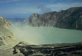
Geological Summary. The Ijen volcano complex at the eastern end of Java consists of a group of small stratovolcanoes constructed within the 20-km-wide Ijen (Kendeng) caldera. The north caldera wall forms a prominent arcuate ridge, but elsewhere the rim was buried by post-caldera volcanoes, including Gunung Merapi, which forms the high point of the complex. Immediately west of the Gunung Merapi stratovolcano is the historically active Kawah Ijen crater, which contains a nearly 1-km-wide, turquoise-colored, acid lake. Kawah Ijen is the site of a labor-intensive mining operation in which baskets of sulfur are hand-carried from the crater floor. Many other post-caldera cones and craters are located within the caldera or along its rim. The largest concentration of cones forms an E-W zone across the southern side of the caldera. Coffee plantations cover much of the caldera floor; nearby waterfalls and hot springs are tourist destinations.
Information Contacts: Dali Ahmad, Volcanological Survey of Indonesia (VSI), Jalan Diponegoro No. 57, Bandung 40122, Indonesia (URL: http://www.vsi.esdm.go.id/); Diego Coppola and David A. Rothery, Department of Earth Sciences, The Open University, Milton Keynes, MK7 6AA, UK. Thermal alerts courtesy of the HIGP MODIS Thermal Alerts Team (URL: http://modis.higp.hawaii.edu/).

