Report on Erta Ale (Ethiopia) — April 2003
Bulletin of the Global Volcanism Network, vol. 28, no. 4 (April 2003)
Managing Editor: Edward Venzke.
Erta Ale (Ethiopia) Frequent changes in the active crater morphology and lava lake level
Please cite this report as:
Global Volcanism Program, 2003. Report on Erta Ale (Ethiopia) (Venzke, E., ed.). Bulletin of the Global Volcanism Network, 28:4. Smithsonian Institution. https://doi.org/10.5479/si.GVP.BGVN200304-221080
Erta Ale
Ethiopia
13.601°N, 40.666°E; summit elev. 585 m
All times are local (unless otherwise noted)
Over the last few years the Afar National Regional State has allowed a program of visitation to Erta Ale volcano by natural science field workers. As a result, numerous expeditions have visited the volcano since November 2000 and January-February 2001 (BGVN 26:12). The following brief reports are a result of some of these visits during January, February, and April 2002, November-December 2002, and January 2003. Typical lava lake activity was commonly reported, but some changes, such as a significant changes of the lake level, were also noted.
Activity during January 2002. Members of the Société de Volcanologie Genève (SVG) visited Erta Ale at the end January 2002. The lava lake remained elliptical with a N-S axis of ~130-133 m and an E-W axis of ~104-111 m; the width had increased ~10 m as a result of crumbling of the terrace along the lake edge. The size of the pit-crater was the same, with an E-W diameter of ~170 m, while the height of the vertical E wall was 46 m. Attempts to measure CO2 and SO2 concentrations inside the crater on 27 January 2002 were unsuccessful because the gas concentrations were below the detection limits of the Dräger tubes (10 ppm SO2 and 0.5% CO2).
Activity during February 2002. During a 14-19 February 2002 stay on Erta Ale by a team that included Roberto Carniel and Jürg Alean (Stromboli Online), the lava lake was active and produced spectacular fountains of lava. The lake level oscillated by several meters during their observation period. Seismic measurements were conducted along with thermal and video recordings of the lake.
Activity during April 2002. During 12-21 April 2002 a group from SVG led by Franck Pothé and Evelyne Pradal visited the volcano and reported significant changes in the morphology and activity of the lava lake since January 2002. The level of the lake had risen ~15 m and its surface area had decreased by ~33%. Over a 36-hour period the level varied intermittently by 1-2 m, the variation sometimes occurring within several minutes. Activity on the lake was intense, with continuous degassing and small lava fountains ~15 m high.
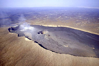
Activity during November-December 2002. A German group from Volcano Expeditions International visited the volcano during November-December 2002. They reported that the S crater was ellipsoidal with dimensions of ~130 m N-S and ~160 m E-W (figure 10). The lava lake occupied about half of the crater, and the lake surface was ~90 m below the W rim of the S pit. The remaining area in the E was covered by basalt that had a terrace ~45 m below the crater rim (figure 10). Previous observations had located the terrace at ~70 m below the rim. It was widely covered with talus; hence, the lava lake must had risen up to the present terrace level between spring 2002 and this visit. Almost no talus was found on the terrace, indicating that the lava cover was not old. Lava fountaining up to 20 m high occurred mainly in the W, S, and center areas of the crater lake. GPS measurements were used to accurately map part of the caldera rim and locate some key points (figure 11).
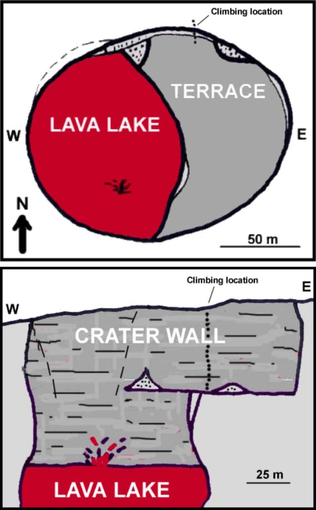 |
Figure 10. A sketch map (top) and E-W cross-section (bottom) of the active S crater at Erta Ale on 4 December 2002.Courtesy of C. Weber. |
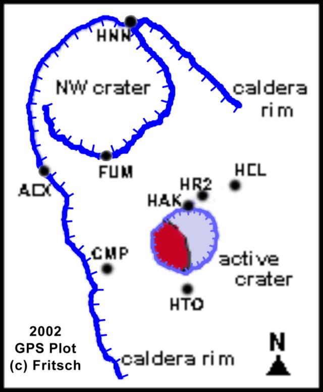 |
Figure 11. Partial survey of the Erta Ale caldera measured using a 12-channel GPS receiver. GPS reception was excellent due to the exposed nature of Erta Ale, where signals are shaded only when the receiver is close to the caldera wall inside the caldera. The GPS point HAK is the climbing location at 13.60402°N, 40.66401°E, and elevation 563.0 m. The highest point was a hornito on the N caldera rim, location HNN, at 13.60829°N, 40.66222°E, elevation 594.9 m. Courtesy of Lothar Fritsch. |
Several earthquakes were felt during the visit. No seismic equipment was present, but five events were felt on 4 and 5 December 2002. No significant change in the lava lake was noticed during these events. Strong fumarolic activity was observed inside and outside the NW crater as well as on the outside of the caldera rim. The surface near the crater rim was broken by cracks in concentric circles, and the crater walls were formed of very unstable material. On 6 December three large rockfalls from crater wall collapses occurred along ~50 m of the crater wall circumference within a few minutes. About 40 m of the wall height collapsed with an estimated average thickness of 10 m, thus ~20,000 m3 of material slid into the lake, creating a large cloud of orange-brown dust that filled the pit and generated large amounts of Pélé's Hair.
Activity during January 2003. French teams from Terra Incognita visited the summit on 4 and 13-14 January 2003. The ~120 m long by 80 m wide lava lake was still in the W portion of the S pit crater; its surface was ~100 m below the crater rim (figure 12). The new platform, located ~50 m below the rim, was in the E part of the crater and covered ~25% of the crater floor. Gas emissions were abundant, and were assumed to be rich in SO2 based on their blue color and strong odor. The lava lake exhibited convection and lava fountains.
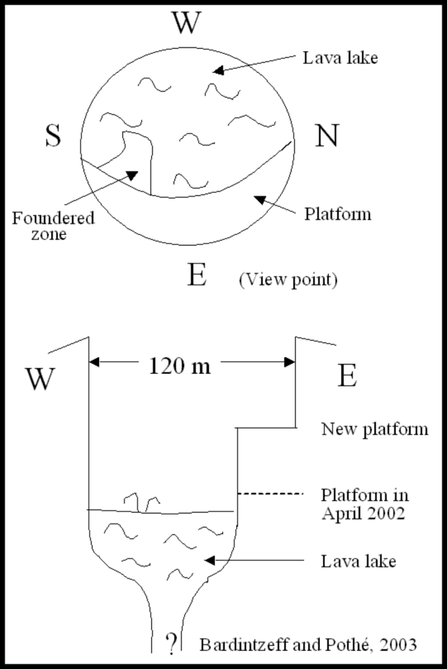 |
Figure 12. Sketch map and cross-section of the Erta Ale lava lake, January 2003. Courtesy of Jacques-Marie Bardintzeff and Franck Pothé. |
Geological Summary. The Erta Ale basaltic shield volcano in Ethiopia has a 50-km-wide edifice that rises more than 600 m from below sea level in the Danakil depression. The volcano includes a 0.7 x 1.6 km summit crater hosting steep-sided pit craters. Another larger 1.8 x 3.1 km wide depression elongated parallel to the trend of the Erta Ale range is located SE of the summit and is bounded by curvilinear fault scarps on the SE side. Basaltic lava flows from these fissures have poured into the caldera and locally overflowed its rim. The summit caldera usually also holds at least one long-term lava lake that has been active since at least 1967, and possibly since 1906. Recent fissure eruptions have occurred on the N flank.
Information Contacts: P. Vetsch, Marc Caillet, Steven Haefeli, and Pierre-Yves Burgi, Société de Volcanologie Genève (SVG), PO Box 6423, CH-1211 Geneva 6, Switzerland (URL: http://www.volcan.ch/); Jürg Alean, Stromboli Online, Rheinstrasse 6, CH-8193 Eglisau, Switzerland (URL: http://www.swisseduc.ch/stromboli/); Christoph Weber and Lothar Fritsch, Volcano Expeditions International (VEI), Muehlweg 11, 74199 Untergruppenbach, Germany; Jacques-Marie Bardintzeff, Université Paris-Sud, F-91405 Orsay, France; Franck Pothé, Terra Incognita, CP 701, 36 quai Arloing 69256 Lyon Cédex, France.