Report on Anatahan (United States) — April 2003

Bulletin of the Global Volcanism Network, vol. 28, no. 4 (April 2003)
Managing Editor: Edward Venzke.
Anatahan (United States) Eruption on 10 May is the first historical activity
Please cite this report as:
Global Volcanism Program, 2003. Report on Anatahan (United States) (Venzke, E., ed.). Bulletin of the Global Volcanism Network, 28:4. Smithsonian Institution. https://doi.org/10.5479/si.GVP.BGVN200304-284200
Anatahan
United States
16.35°N, 145.67°E; summit elev. 790 m
All times are local (unless otherwise noted)
An explosive eruption on 10 May at Anatahan marked the first report of activity at the volcano since an earthquake swarm on 29 May 1993 that led to the evacuation of the island (BGVN 18:05 and 18:08). No eruptions had previously been documented in historical time from this small volcanic island in the Commonwealth of the Northern Mariana Islands (CNMI) (figure 2).
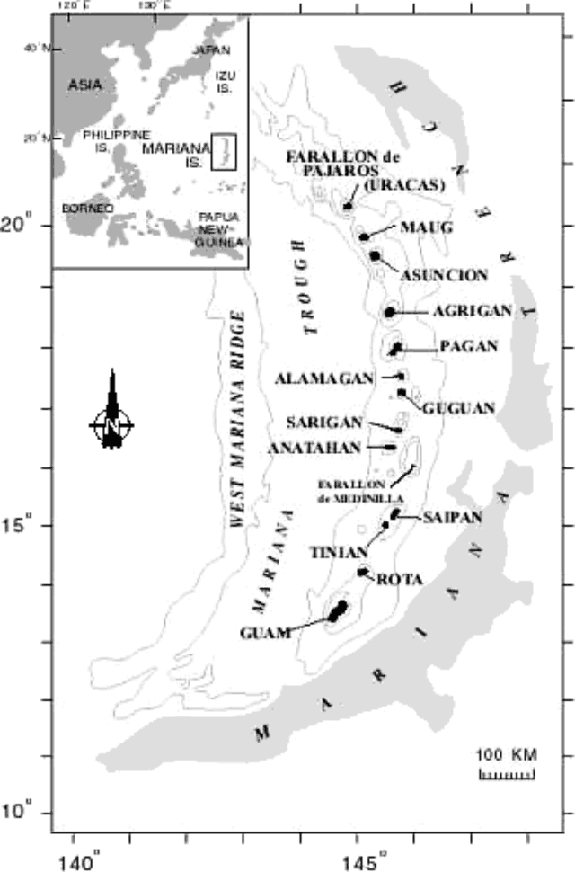 |
Figure 2. Map of the Mariana Islands and outline of the adjacent Mariana Trench. The Commonwealth of the Northern Mariana Islands extends from Rota in the south to Farallon de Pajaros in the north. The island of Anatahan is approximately 9 km long and 4 km wide. Courtesy of CNMI Emergency Management Office. |
A group of scientists was near Anatahan on 10 May deploying seismographs for the Margins Mariana Subduction Factory Imaging Project, which is comprised of members from Washington University, St. Louis; Scripps Inst. of Oceanography; and CNMI Emergency Management Office. They passed Anatahan as the eruption was occurring. The island was uninhabited at the time. According to members of the research group who viewed the eruption from about 10 km away, the eruption began on 10 May around 1700. The CNMI Emergency Management Office (EMO) reported that the ash cloud produced from the eruption eventually rose to an altitude of ~12 km (figure 3). During an observational helicopter flight, EMO personnel discovered that the eruption was emanating from the eastern crater (figure 4). They noted that only ash was being emitted, no lava flows were seen, and no explosions were seen or heard. The scientists had visited the island on 6 May and saw no signs of any unusual activity.
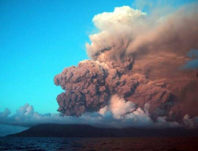 |
Figure 3. Photograph taken on 10 May 2003 of an ash cloud produced from the eruption of Anatahan that began that day. The cloud top is at ~ 4.6 km and emanates from the eastern crater. The view is toward the SW. Courtesy of CNMI Emergency Management Office. |
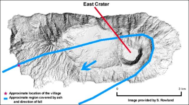 |
Figure 4. Map of Anatahan showing the deep pit on the eastern side of the summit, which is referred to as the East Crater, and is the source of the eruption that began on 10 May 2003. Courtesy of Scott Rowland, University of Hawaii Manoa. |
The Washington Volcanic Ash Advisory Center (VAAC) issued an advisory about the Anatahan eruption stating that an ash cloud was visible on satellite imagery on 10 May at 2232 at an estimated altitude of 10.5 km. One layer of the ash cloud drifted south at a speed of ~65 km/hour, and a lower level at an altitude of ~4.5 km drifted W at ~28 km/hr. By 0655 the next day ash was seen in satellite imagery drifting in three different directions: WNW at an altitude around 5.5 km, SW around 8.5 km, and two separate and smaller ash plumes were drifting SE at altitudes around 13.4 km. At this time, a hotspot was visible on GOES-9 imagery.
On 11 May the CNMI Emergency Management Office, Office of the Director issued a special advisory stating, "Due to this active volcano eruption with high level clouds and [an] ash plume, the general public especially fishermen, tour operators and commercial pilots are advise[d] to stay away from the island of Anatahan until further notice from the Office of Emergency Management." The eruption continued through at least 14 May, when the Washington VAAC issued an ash advisory stating that ash was visible on satellite imagery drifting W of Anatahan at an altitude of ~4.9 km.
Geological Summary. The elongate, 9-km-long island of Anatahan in the central Mariana Islands consists of a large stratovolcano with a 2.3 x 5 km compound summit caldera. The larger western portion of the caldera is 2.3 x 3 km wide, and its western rim forms the island's high point. Ponded lava flows overlain by pyroclastic deposits fill the floor of the western caldera, whose SW side is cut by a fresh-looking smaller crater. The 2-km-wide eastern portion of the caldera contained a steep-walled inner crater whose floor prior to the 2003 eruption was only 68 m above sea level. A submarine cone, named NE Anatahan, rises to within 460 m of the sea surface on the NE flank, and numerous other submarine vents are found on the NE-to-SE flanks. Sparseness of vegetation on the most recent lava flows had indicated that they were of Holocene age, but the first historical eruption did not occur until May 2003, when a large explosive eruption took place forming a new crater inside the eastern caldera.
Information Contacts: Doug Wiens, Washington University, St. Louis, McDonnell Hall 403 Box 1169, St. Louis, MO 63130; Allan Sauter, Scripps Institution of Oceanography, UCSD, 9500 Gilman Drive, La Jolla CA, 92093-0225; Juan Camacho, Commonwealth of the Northern Mariana Islands Emergency Management Office, P.O. Box 10007, Saipan, MP 96950 (URL: http://www.cnmihsem.gov.mp/); Washington VAAC, Satellite Analysis Branch (SAB), NOAA/NESDIS E/SP23, NOAA Science Center Room 401, 5200 Auth Road, Camp Springs, MD 20746, USA (URL: http://www.ssd.noaa.gov/); Scott Rowland, University of Hawai'i at Manoa, Hawai'i Institute of Geophysics and Planetology, 1680 East-West Road, POST 602, Honolulu, HI 96822; Frank Trusdell, Hawaiian Volcano Observatory, PO Box 51, Hawaii National Park, HI, 96718-0051.