Report on Papandayan (Indonesia) — July 2003
Bulletin of the Global Volcanism Network, vol. 28, no. 7 (July 2003)
Managing Editor: Edward Venzke.
Papandayan (Indonesia) After the explosions of November 2002, seismicity and eruptions waned
Please cite this report as:
Global Volcanism Program, 2003. Report on Papandayan (Indonesia) (Venzke, E., ed.). Bulletin of the Global Volcanism Network, 28:7. Smithsonian Institution. https://doi.org/10.5479/si.GVP.BGVN200307-263100
Papandayan
Indonesia
7.32°S, 107.73°E; summit elev. 2665 m
All times are local (unless otherwise noted)
On 11 November 2002, ash eruptions occurred at Papandayan (BGVN 27:11 and figure 8). Subsequently, seismic and eruptive activity waned, although gas emission continued (ending 4 May 2003). Lessening seismicity and volcanism in January 2003 resulted in a reduction of the hazard status from 3 to 2 (on a scale of 1 to 4, where 4 is the highest). Reduction in the activity continued through the beginning of May 2003 at which time the Volcanological Survey of Indonesia (VSI) terminated its weekly reporting on Papandayan.
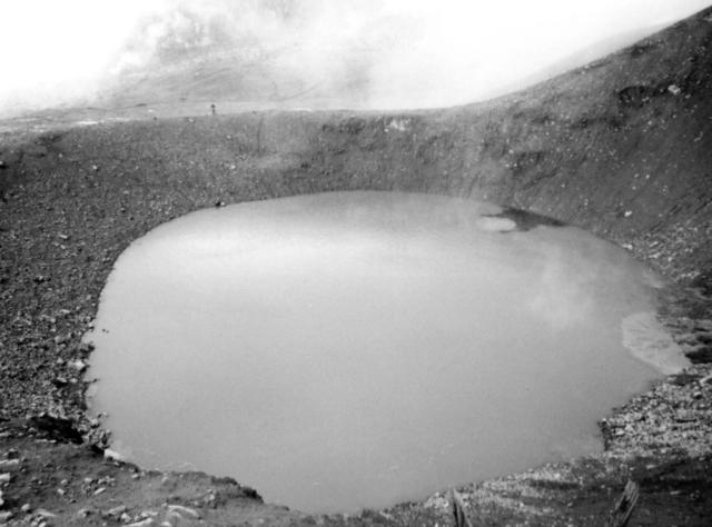 |
Figure 8. Photograph of the new crater at Papandayan formed on 11 November 2002; by 8 December it was no longer active and was filled by water. The crater diameter is ~ 300 m. Courtesy of VSI. |
During December 2002, white-gray ash plume was emitted continually from Baru crater and rose 150-400 m to the NE. [After the week of 16-22 December only gas plumes were emitted (described as "white ash emission").] As the activity level reduced (table 2) the typical height of the plume dropped from 150-400 m during December and early January 2003 to 75-250 m by late-January.
Table 2. Weekly seismic events at Papandayan from 2 December 2002 to 4 May 2003. Courtesy of VSI.
| Date | Deep | Shallow | Tectonic | Avalanches |
| 02 Dec-08 Dec 2002 | 9 | 10 | 17 | -- |
| 09 Dec-15 Dec 2002 | 1 | 25 | -- | -- |
| 16 Dec-22 Dec 2002 | 1 | 20 | 21 | -- |
| 23 Dec-29 Dec 2002 | 3 | 16 | 12 | -- |
| 30 Dec-05 Jan 2003 | 28 | 42 | 29 | -- |
| 06 Jan-12 Jan 2003 | 11 | 21 | 33 | 7 |
| 13 Jan-19 Jan 2003 | 7 | 11 | 16 | 12 |
| 20 Jan-26 Jan 2003 | 14 | 30 | 29 | -- |
| 27 Jan-02 Feb 2003 | 8 | 25 | 30 | -- |
| 03 Feb-09 Feb 2003 | 3 | 18 | 12 | 1 |
| 10 Feb-16 Feb 2003 | -- | 14 | 18 | 2 |
| 17 Feb-23 Feb 2003 | 3 | 24 | 17 | 3 |
| 24 Feb-02 Mar 2003 | 2 | 1 | 3 | -- |
| 03 Mar-09 Mar 2003 | -- | 1 | -- | 7 |
| 10 Mar-16 Mar 2003 | 1 | 10 | 16 | -- |
| 17 Mar-23 Mar 2003 | 2 | 8 | 24 | -- |
| 24 Mar-30 Mar 2003 | 2 | 10 | 14 | -- |
| 31 Mar-06 Apr 2003 | 3 | 15 | 33 | -- |
| 07 Apr-13 Apr 2003 | 1 | 8 | 9 | -- |
| 14 Apr-20 Apr 2003 | 2 | 12 | 16 | -- |
| 21 Apr-27 Apr 2003 | 8 | 5 | 23 | -- |
| 28 Apr-04 May 2003 | 2 | 7 | 3 | -- |
Two explosions occurred at 0700 on 4 December and at 1758 on 8 December 2002, and another occurred at 1758 on 12 December. During the week of 2-8 December, shallow volcanic earthquakes decreased, while deep volcanic and tectonic earthquakes increased. During the subsequent week, shallow earthquakes increased, while deep earthquakes decreased (table 2). Insignificant lahars occurred at Cibeureum Gede and Ciparugpug rivers at 1600 on 13 December and at 1700 on 14 December. The movement of stepped landslides on the wall of Nangklak crater were recorded on the seismograph throughout most of December; the last landslide occurred at 1154 on 21 December. The hazard level was reduced to 2 by the week of 13-19 January 2003.
Geological Summary. Papandayan is a complex stratovolcano with four large summit craters, the youngest of which was breached to the NE by collapse during a brief eruption in 1772 and contains active fumarole fields. The broad 1.1-km-wide, flat-floored Alun-Alun crater truncates the summit of Papandayan, and Gunung Puntang to the north gives a twin-peaked appearance. Several episodes of collapse have created an irregular profile and produced debris avalanches that have impacted lowland areas. A sulfur-encrusted fumarole field occupies historically active Kawah Mas ("Golden Crater"). After its first historical eruption in 1772, in which collapse of the NE flank produced a catastrophic debris avalanche that destroyed 40 villages and killed nearly 3000 people, only small phreatic eruptions had occurred prior to an explosive eruption that began in November 2002.
Information Contacts: Dali Ahmad, Volcanological Survey of Indonesia (VSI), Jalan Diponegoro No. 57, Bandung 40122, Indonesia (URL: http://www.vsi.esdm.go.id/).