Report on Anatahan (United States) — July 2003

Bulletin of the Global Volcanism Network, vol. 28, no. 7 (July 2003)
Managing Editor: Edward Venzke.
Anatahan (United States) Observations of deposits from the eruptive sequence that began 10 May 2003
Please cite this report as:
Global Volcanism Program, 2003. Report on Anatahan (United States) (Venzke, E., ed.). Bulletin of the Global Volcanism Network, 28:7. Smithsonian Institution. https://doi.org/10.5479/si.GVP.BGVN200307-284200
Anatahan
United States
16.35°N, 145.67°E; summit elev. 790 m
All times are local (unless otherwise noted)
Anatahan erupted on the evening of 10 May 2003 (BGVN 28:04). The volcano, which forms the uninhabited Anatahan Island in the Commonwealth of the Northern Mariana Islands (CNMI), had no recorded historical eruptions. This report provides observations from a 25 July 2003 report (updated 31 July 2003) by the University of Tokyo Earthquake Research Institute (ERI) documenting fieldwork by their team during 16-19 July 2003. During the inspection, the volcano was quiet, with only weak steaming at the active crater. Seismicity reported by the Commonwealth of the Northern Mariana Islands (CNMI) Emergency Management Office continued into early August.
Tephra deposits. The recent eruption left recognizable tephra deposits consisting mainly of pumice-bearing brown ash in a lower unit and fine gray ash in an upper unit (figure 10). Both the upper and lower units consist of many sub-layers. At the village (NW end of the island) the total thickness of brown ash was 20 cm and gray ash was 3 cm.
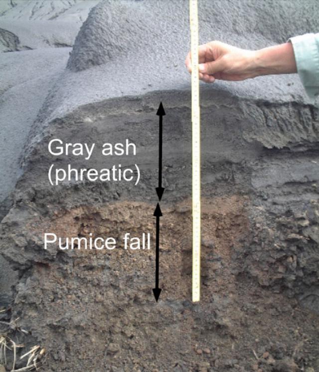 |
Figure 10. Section of tephra seen just S of Anatahan's active crater on 18 July showing deposits laid down in the eruptions that began in May 2003. The section contains a lower (brown) pumice-fall deposit (~ 25 cm thick) covered by multiple layers (~ 20 cm thick) of gray ash from phreatic eruptions. Courtesy of S. Nakada, University of Tokyo. |
At the SE part of the island tephra deposits were less than 3 cm thick. Although grass and trees did not show heat damage, plastic bottles had melted. The outer S slope of the active crater in the E caldera was thickly covered by gray ash. Many rills and gullies developed on these deposits due to the impermeable nature of the gray ash, which typically consisted of very fine particles. Occasionally the observers noted partly broken, stripped trees on the slopes, with a thick cover of gray tephra accumulated on the side facing the active crater. Tephra was ~20 cm thick near the crater rim and pumice-bearing tephra below was ~25 cm thick. The latter included blocks and fragments of pumice.
Inside the W caldera, tephra deposits reached a thickness of up to 1 m. Gray ash was deposited most thickly NW of the crater. Pumice-bearing tephra was thickest in the WSW direction from the crater. The latter is consistent with the drift direction of eruption plumes in the earliest stage shown by satellite images (BGVN 28:06). Although most of the trees had survived falling pumice early during the eruption, they were toppled by the strong lateral movement of gray ash during the phreatic phase.
Crater observations. The mid-July fieldwork included two days of helicopter inspection; observers saw only steaming at the active crater. That crater occupied the S part of the E crater, which lies inside the E caldera. The S wall of the active crater extended directly into the wall of the E crater. The new crater was ~300 m across and ~100 m deep, with the deepest part in the S containing a dried-out mud pool.
A mound-like but rugged-ridged lava dome protruded along the active crater's inner N periphery (figure 11). The surface of this recently erupted dome lay beneath a thick cover of gray ash associated with the phreatic eruption. Infrared camera images indicate that it remained at higher temperature than deposits outside the crater.
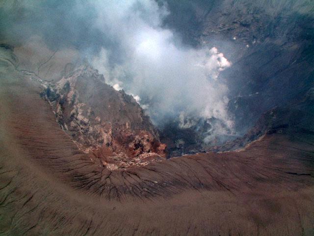 |
Figure 11. Aerial view showing the steaming crater at Anatahan from the NW on 19 July 2003. The lava dome (center left) lies inside the crater. A pyroclastic cone had developed on the N side, surrounding the crater. Courtesy of S. Nakada, University of Tokyo. |
The dome may have been broken by explosive eruptions in mid-June when high seismic and visual activities were reported. Products of a reamed-out dome may have been broken into small clasts, widely dispersed, and buried by later deposits. On the other hand, neither bombs nor blocks were clearly visible on the floors of either the E crater (outside the pyroclastic cone) or in the E caldera. Thus, the absence of large blocks of lava dome around the active crater could suggest that the original dimensions of the lava dome may have been small and that the dome had undergone comparatively little sculpting by later explosions.
A low pyroclastic cone developed on the crater's N side (figure 11). The maximum thickness of newly deposited tephra exposed in a gully through this cone reached ~20 m.
Chemistry and degassing of magma. Pumice from this eruption was crystal-poor and light to dark brown in color. A pumice block with a light-brown crust and dark-brown vesicular core collected from the pumice-fall layer just S of the active crater was analyzed by x-ray fluorescence spectroscopy at ERI. The crust and core parts were separately analyzed; each contained 61 weight percent SiO2.
Observers saw blue- to purple-colored gas escaping the active crater and smelled a strong rotten-egg near the S rim of the E caldera on 18 July. Instrumental concentration estimates measured 2-4 ppm SO2 and 0.5 ppm H2S. The SO2 emission rate remained moderate to low throughout the inspection; the total SO2 flux was probably less than several thousand tons a day, similar to that at Sakurajima, Japan.
Ongoing activity, July into early August. According to CNMI reports, volcanic tremor and other seismicity at Anatahan persisted through July and into August 2003 at a relatively low level. On 1 August the Anatahan seismic station registered a small swarm of a dozen or so long-period (LP) events of approximate magnitude 1; similar swarms occurred on 4 and 5 August. Several hundred small (LP) events occurred during 5-6 August. The number of small LP events was greater than that of previous days, but the overall energy release appears not to have increased significantly. No LP events were recorded on 7 August.
Geological Summary. The elongate, 9-km-long island of Anatahan in the central Mariana Islands consists of a large stratovolcano with a 2.3 x 5 km compound summit caldera. The larger western portion of the caldera is 2.3 x 3 km wide, and its western rim forms the island's high point. Ponded lava flows overlain by pyroclastic deposits fill the floor of the western caldera, whose SW side is cut by a fresh-looking smaller crater. The 2-km-wide eastern portion of the caldera contained a steep-walled inner crater whose floor prior to the 2003 eruption was only 68 m above sea level. A submarine cone, named NE Anatahan, rises to within 460 m of the sea surface on the NE flank, and numerous other submarine vents are found on the NE-to-SE flanks. Sparseness of vegetation on the most recent lava flows had indicated that they were of Holocene age, but the first historical eruption did not occur until May 2003, when a large explosive eruption took place forming a new crater inside the eastern caldera.
Information Contacts: Setsuya Nakada and Teruyuki Kato, Volcano Research Center, Earthquake Research Institute (ERI), University of Tokyo (URL: http://www.eri.u-tokyo.ac.jp/VRC/index_E.html); Takeshi Matsushima, Institute of Seismology and Volcanology (SEVO), Kyushu University, Japan; Juan Takai Camacho and Ramon Chong, Commonwealth of the Northern Mariana Islands (CNMI) Emergency Management Office, P.O. Box 10007, Saipan, MP 96950, USA (URL: http://www.cnmihsem.gov.mp/).