Report on Soufriere Hills (United Kingdom) — July 2003

Bulletin of the Global Volcanism Network, vol. 28, no. 7 (July 2003)
Managing Editor: Edward Venzke.
Soufriere Hills (United Kingdom) Changes in activity style and dome growth since February 2002
Please cite this report as:
Global Volcanism Program, 2003. Report on Soufriere Hills (United Kingdom) (Venzke, E., ed.). Bulletin of the Global Volcanism Network, 28:7. Smithsonian Institution. https://doi.org/10.5479/si.GVP.BGVN200307-360050
Soufriere Hills
United Kingdom
16.72°N, 62.18°W; summit elev. 915 m
All times are local (unless otherwise noted)
Although detailed reports about the activity and monitoring of Soufrière Hills are provided on a regular basis by the Montserrat Volcano Observatory, this report contains observations made by visitors Stephen O'Meara and Robert Benward. They monitored Soufrière Hills visually and, using some novel electronics, collected data and images for 12 days beginning on 7 February 2003. This visit was similar to one in February 2002 (BGVN 27:06).
The visual observations took place primarily on Jack Boy Hill, 6 km N of the volcano. At the new Montserrat Volcano Observatory, Benward set up a black and white CCD video camera that took a frame every eight (8) seconds and relayed it to a digital video recorder. The camera's low-light sensitivity provided round-the-clock surveillance of dome activity. However, orographic and rain clouds caused problems, and much of the volcanic activity was away from the camera view.
Since the visit in 2002, the dome had increased significantly in size (figure 56). The rockfalls and pyroclastic flows that dominated the activity in February 2002 were concentrated in the E portions of the dome and the Tar River Valley. In 2003, activity occurred in a broader arc that extended from Tar River in the E to Farrell's Plain in the N. Several pyroclastic flows traveled into Tuitt's Ghaut and the upper reaches of Tyre's Ghaut, and onto Farrell's Plain. These events were captured on the surveillance camera and in higher-definition color video taken from Jack Boy Hill.
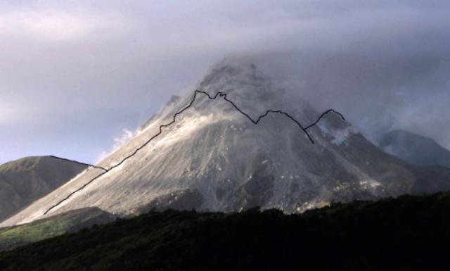 |
Figure 56. Illustration of dome growth at Soufriere Hills between February 2002 and February 2003. The outline of the volcano's profile in February 2002 is superimposed on a photograph taken at the same location in February 2003. Courtesy of Robert Benward, Volcano Watch International. |
The dome was impressive at night. The summit was often crowned with thick, blocky spines and sharp pinnacles. An array of spiny ridges (speckled with incandescence) that lined the upper portions of the dome helped channelize many of the rockfalls and pyroclastic flows, the flow channels remaining incandescent. The glow was strong throughout the observation period, but especially during 13-19 February, when episodes of prolonged activity made the dome appear to be melting like candle wax. The glowing dome could be seen from the northernmost reaches of the island at night. Its light was so intense that a homemade spectrograph (attached to a 3-inch telescope brought by Benward) revealed a continuous spectrum.
O'Meara visually observed the dome through a 60 power, 60 mm refractor scope and noticed two curious phenomena. At one point, a mass of viscous, but mobile, lava pushed out of the downslope edge of an incandescent ridge. It slumped onto the dome and formed a pad of molten material that quickly cooled and solidified into linear veins. The behavior was similar to that of a budding toe of pahoehoe lava where internal pressure forces fluid lava through its cooling skin. O'Meara also observed what appeared to be a tiny lateral explosion from the downslope edge of an incandescent ridge which shot out glowing gas and rock fragments like buckshot from a gun.
A significant difference in the style of eruption from that reported in 2002 was the periodic mass dumping of dome material. During these episodes, dome material calved off the highest portions of the dome, creating a wide avalanche of incandescent material which flowed down much of the dome's visible face in a matter of seconds. These episodes differed from the classical pyroclastic flows in that they produced comparatively little ash, being comprised principally of extremely massive and widespread rock and block fall.
A dramatic episode of rockfall and pyroclastic-flow activity occurred during 1745-2000 on 13 February. Massive movement of large, house-sized blocks, many of which self-destructed during their descent, preceded the pyroclastic flows. The subsequent pyroclastic flow activity was accompanied by roiling steel-gray ash clouds that drifted N. One particularly strong pyroclastic flow created an incandescent channel in Tuitt's Ghaut that glowed long into the night. Smaller pyroclastic flows followed this channel downslope, while larger ones overflowed the channel's levees or changed course. Often, when one flow slowed, another would push through it. At times pieces of incandescent rocks appeared to be sliding down the dome in the flow with no detectable rolling motion. At other times, linear threads of glowing gases appeared to advance like the treads of a tank. Another series of pyroclastic flows during 0614-0730 on 14 February were directed N, and spread out across Farrell's Plain. As in February 2002, the night activity was most spectacular when viewed and videotaped in the near-IR using Benward's homemade nightscope.
One purpose of the visit was to chronicle changes in visible behavior when the full Moon approached Earth and at perigee. With the approach of the full Moon, the team reported an apparent rise in the number of visible indicators, particularly an increase in the number of large and prolonged rockfalls and pyroclastic flows, and in the average number of events per hour. There was an impressive episode of spine growth in the 24 hours near the time of full Moon, similar to that in 2002. The limited duration of the observations, however, thwart conclusions about the relationships between lunar positions and volcanism. Convincing theories require baseline data over a considerably longer time period.
Geological Summary. The complex, dominantly andesitic Soufrière Hills volcano occupies the southern half of the island of Montserrat. The summit area consists primarily of a series of lava domes emplaced along an ESE-trending zone. The volcano is flanked by Pleistocene complexes to the north and south. English's Crater, a 1-km-wide crater breached widely to the east by edifice collapse, was formed about 2000 years ago as a result of the youngest of several collapse events producing submarine debris-avalanche deposits. Block-and-ash flow and surge deposits associated with dome growth predominate in flank deposits, including those from an eruption that likely preceded the 1632 CE settlement of the island, allowing cultivation on recently devegetated land to near the summit. Non-eruptive seismic swarms occurred at 30-year intervals in the 20th century, but no historical eruptions were recorded until 1995. Long-term small-to-moderate ash eruptions beginning in that year were later accompanied by lava-dome growth and pyroclastic flows that forced evacuation of the southern half of the island and ultimately destroyed the capital city of Plymouth, causing major social and economic disruption.
Information Contacts: Steve and Donna O'Meara, and Robert Benward, Volcano Watch International, PO Box 218, Volcano, HI 96785, USA.