Report on Karthala (Comoros) — August 2003
Bulletin of the Global Volcanism Network, vol. 28, no. 8 (August 2003)
Managing Editor: Edward Venzke.
Karthala (Comoros) Increased shallow seismic activity to 100 events per day by late August
Please cite this report as:
Global Volcanism Program, 2003. Report on Karthala (Comoros) (Venzke, E., ed.). Bulletin of the Global Volcanism Network, 28:8. Smithsonian Institution. https://doi.org/10.5479/si.GVP.BGVN200308-233010
Karthala
Comoros
11.75°S, 43.38°E; summit elev. 2361 m
All times are local (unless otherwise noted)
Since July 2003, Karthala has exhibited significant, but relatively shallow, seismicity. As of 28 August, P. Bachelery of the University of La Réunion reported that an average of 100 seismic events/day were being recorded, some felt by the local population.
The first seismic station was installed at the Karthala Volcanological Observatory in 1988 by the University of La Réunion and the Institut de Physique du Globe de Paris (IPGP). During the summer and fall of 2000 increased seismicity was reported, and an earthquake swarm was recorded in October 2000 (BGVN 25:10). In April 1991, a notable increase in the number of seismic events began and, after about three months of seismic activity, there was an eruption in July (BGVN 16:06 and 16:08).
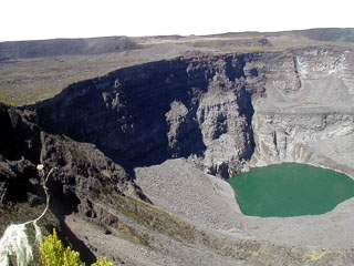
Geological Summary. The southernmost and largest of the two shield volcanoes forming Grand Comore Island (also known as Ngazidja Island), Karthala contains a 3 x 4 km summit caldera generated by repeated collapse. Elongated rift zones extend to the NNW and SE from the summit of the Hawaiian-style basaltic shield, which has an asymmetrical profile that is steeper to the S. The lower SE rift zone forms the Massif du Badjini, a peninsula at the SE tip of the island. Historical eruptions have modified the morphology of the compound, irregular summit caldera. More than twenty eruptions have been recorded since the 19th century from the summit caldera and vents on the N and S flanks. Many lava flows have reached the sea on both sides of the island. An 1860 lava flow from the summit caldera traveled ~13 km to the NW, reaching the W coast to the N of the capital city of Moroni.
Information Contacts: Patrick Bachelery, Laboratoire des Sciences de la Terre, Université de La Réunion BP 7151, 15 Avenue, René Cassin, 97715 Saint-Denis (URL: http://volcano.ipgp.jussieu.fr/karthala/stationkar.html).

