Report on Poas (Costa Rica) — September 2003
Bulletin of the Global Volcanism Network, vol. 28, no. 9 (September 2003)
Managing Editor: Edward Venzke.
Poas (Costa Rica) Hydrothermally active repose continues through 2002
Please cite this report as:
Global Volcanism Program, 2003. Report on Poas (Costa Rica) (Venzke, E., ed.). Bulletin of the Global Volcanism Network, 28:9. Smithsonian Institution. https://doi.org/10.5479/si.GVP.BGVN200309-345040
Poas
Costa Rica
10.2°N, 84.233°W; summit elev. 2697 m
All times are local (unless otherwise noted)
This report concerns Poás during the interval September 2001 through December 2002. It draws on both a set of extensive half-year reports from UCR-ICE (Mora, 2001a, b; 2002) and monthly OVSICORI-UNA reports (available on the web, and sometimes prepared with co-authors Orlando Vaselli and Franco Tassi). OVSICORI-UNA reports were absent for November and December 2001.
Poás was non-eruptive during the reporting interval. The key focus of activity remains the main crater and its fumaroles, and its low-pH, variably colored lake. That lake is sometimes called Laguna Caliente or el Poás, but more frequently in past issues of the Bulletin simply described with terms like the active lake, lake in the active crater, hot lake, etc. During the reporting interval the active lake repeatedly changed pH, color, and temperature. As in the past, Laguna Caliente contained some thermally active zones, sometimes displaying up-welling water, bubbles, and zones of native sulfur. Lake Botos lies in a crater S of the active one. It remained inactive.
The origin and terminology for the main crater's dome or pyroclastic cone remains controversial; both terms are used in this report, congruent with those favored by the authors of summarized reports and included photos. Whatever its name or origin, this feature supports especially active fumaroles, and is frequently masked by steam.
Observers at the crater noted acoustical noise from vigorous degassing. Again, as typical, monthly reports consistently mentioned variable secondary fumarolic activity and occasional mass-wasting along the crater walls. Seismicity, including tremor, continued and is mentioned below, but it will be discussed more comprehensively in a later report.
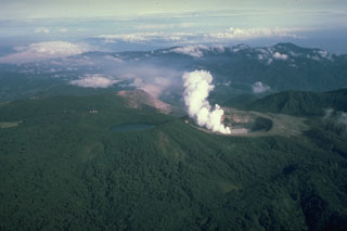
UCR-ICE observations. Mora (2001b and 2002) included an overview photo of Poás (figure 74). Those reports also included numerous other photos of fumaroles and mass wasting, most of which are not shown here. Some pronounced arcuate cracks associated with mass wasting along the NE side of the lake were thought possibly related to changes in lake level and pore pressure (figure 75). A shot of the steaming dome appears as figure 76.
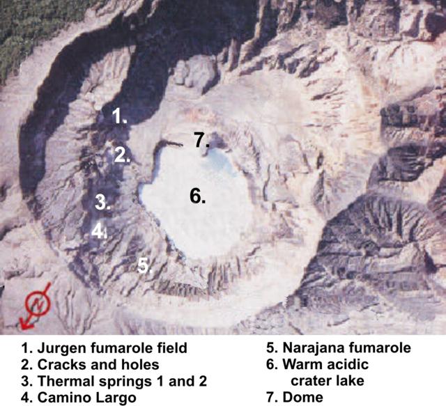 |
Figure 74. A vertical or sub-vertical aerial photo taken of the summit at Poás, with N toward the bottom left. Numbers on the photo refer to locations named on the key. As an approximate scale, the lake is ~ 200-300 m in diameter. This was taken from figures in Mora (2001a and b, and 2002) that had several other photos around the margin. Construction lines originally across this photo have been removed here, with some resulting loss and local misrepresentation of what must have been present on the original photo. Courtesy of UCR-ICE (after Mora 2001b and 2002). |
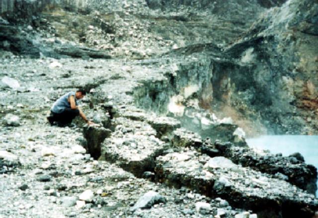 |
Figure 75. Laguna Caliente, the hot lake at Poás (lower right) lies within a crater bounded by unstable cliffs. This photo shows part of the lake's NE margin. The person in this scene stands on a substantial though eroding terrace and inspects arcuate cracks (circumferential faults) in unstable material along the crater rim. Some of these cracks reached 40 cm wide. Landslide deposits from failures along this and other cliff faces were mentioned frequently in reports. Courtesy of UCR-ICE (from Mora 2001a). |
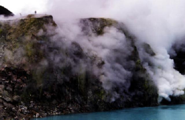 |
Figure 76. The N face of the dome (or pyroclastic cone) at Poás rises from the lake and supports strong fumaroles. This photo was taken looking S. Scientists partially visible atop the dome were walking to fumaroles where they measured gas temperatures and pH. Courtesy of UCR-ICE (from Mora, 2001). |
Mora (2001a, b and 2002) collected and presented considerable data on Laguna Caliente, and we include several available plots. Lake temperature and pH during 2001-2 appears as figure 77; precipitation and lake level for most of 2002, as figure 78.
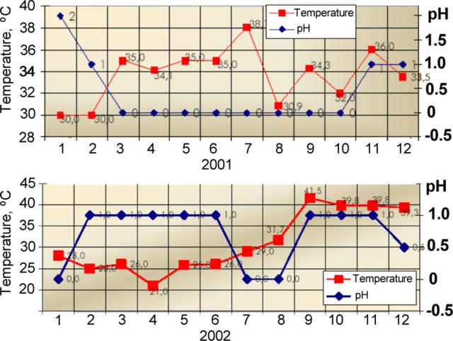 |
Figure 77. For Laguna Caliente at Poás, plots showing temperature and pH versus month during (top) 2001 and (bottom) 2002. The various scales are unequal. The two-year peak temperature measured 41.5°C in September 2002. The lowest pH measured ~ 0 during March-October 2001 and during January, July, and August 2002. (After Mora, 2001b and 2002). |
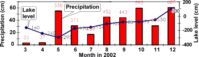 |
Figure 78. For Laguna Caliente at Poás, a plot showing precipitation and lake-surface level versus month during March-December 2002. The location where the precipitation measurements were taken was unstated. Values shown on the plot are in millimeters (After Mora, 2002). |
Mora (2002) reported March-December 2002 precipitation ranging from 33 to 607 mm per month (figure 78). The lake's variable surface heights during March-December 2002 deviated from an established (arbitrary) datum (zero point), from which heights ranged from ~ 400 mm below the datum to ~ 100 mm above it. During this interval the lake's high stand occurred in December; it then covered the border of the lowest N terrace. The lowest stand for the interval occurred during May. During this time interval the variables of precipitation and lake height appeared to lack consistent correlation.
OVSICORI-UNA observations. During late 2001 and through 2002, low-frequency earthquakes continued to dominate the record, with OVSICORI-UNA reporting ~ 500 events per day on 8 September, but more typically 100-300 events per day. In addition during this interval instruments typically recorded several hours of tremor per month. During some months of the reporting interval, medium- and high-frequency earthquakes continued to occur in conjunction with new fumaroles appearing in the active crater.
The OVSICORI-UNA report discussing September 2002 noted that tremor rose slightly, prevailing for ~ 5 hours on each of several days. Long-period earthquakes numbered more than 100 per day, and typically 300-450 per day. Medium-frequency earthquakes occurred much less often, their numbers approaching ~ 20 per day on several days, and more typically fewer than 10 per day.
During the last half of 2002 the lake's water temperature rose above 30°C, attaining 39°C during September-December 2002. Lowered air temperatures in late 2002, particularly in November 2002, led to condensate forming over the lake's surface and rising to accumulate in larger, optically dense clouds (figure 79).
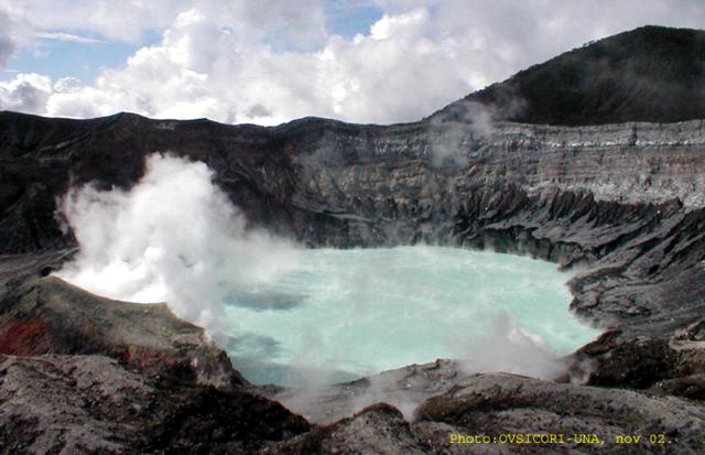 |
Figure 79. Conspicuous condensate hung over the active crater lake at Poás during late 2002. The condensate stemmed from warm lake temperatures (~ 39°C) combined with cooler ambient air temperatures. At the time of this photo (November 2002) the lake was light green in color. Courtesy of OVSICORI-UNA. |
References. Mora, R., 2002, Informe anual de la actividad de la Cordillera Volcánica Central, 2002, Costa Rica (proofed and revised by Alvarado, G., Fernández, M., Mora, M., Paniagua S., and Ramírez, C.): Universidad de Costa Rica, Red Sismológica Nacional, UCR-ICE, Sección de Sismología, Vulcanologíay Exploración Geofísica (published June 2003 as mini-CD Rom with PDF files).
Mora, R., 2001a, Informe semestral de la actividad de la Cordillera Volcánica Central, Enero-Junio 2001, Costa Rica: Universidad de Costa Rica, Red Sismológica Nacional, UCR-ICE, Sección de Sismología, Vulcanologíay Exploración Geofísica (published November 2001 as mini-CD Rom with PDF files).
Mora, R., 2001b, Informe semestral de la actividad de la Cordillera Volcánica Central, Julio-Diciembre 2001, Costa Rica (proofed and revised by Alvarado, G., Fernández, M., Montero, W., and Ramírez, C.): Universidad de Costa Rica, Red Sismológica Nacional, UCR-ICE, Sección de Sismología, Vulcanologíay Exploración Geofísica (published 6 May 2001 as mini-CD Rom with PDF files).
Geological Summary. The broad vegetated edifice of Poás, one of the most active volcanoes of Costa Rica, contains three craters along a N-S line. The frequently visited multi-hued summit crater lakes of the basaltic-to-dacitic volcano are easily accessible by vehicle from the nearby capital city of San José. A N-S-trending fissure cutting the complex stratovolcano extends to the lower N flank, where it has produced the Congo stratovolcano and several lake-filled maars. The southernmost of the two summit crater lakes, Botos, last erupted about 7,500 years ago. The more prominent geothermally heated northern lake, Laguna Caliente, is one of the world's most acidic natural lakes, with a pH of near zero. It has been the site of frequent phreatic and phreatomagmatic eruptions since an eruption was reported in 1828. Eruptions often include geyser-like ejections of crater-lake water.
Information Contacts: R. Mora (Amador), C. Ramírez, and M. Fernández, Universidad de Costa Rica, Laboratorio de Sismologia, Vulcanología y Exploración Geofisica, Aptdo. 560-2300, Curridabat, San José, Costa Rica; E. Fernández, E. Duarte, E. Malavassi, R. Sáenz, V. Barboza, R. Van der Laat, T. Marino, E. Hernández, and F. Chavarría, Observatorio Vulcanológico y Sismológico de Costa Rica (OVSICORI-UNA); Jorge Barquero and Wendy Sáenz, Laboratorio de Química de la Atmósfera (LAQAT), Depto. de Química, Universidad Nacional, Heredia, Costa Rica; María Martínez (at both affiliations above); Orlando Vaselli and Franco Tassi, Department of Earth Sciences, University of Florence, Via La Pira 4, 50121 Florence, Italy.