Report on Alaid (Russia) — October 2003
Bulletin of the Global Volcanism Network, vol. 28, no. 10 (October 2003)
Managing Editor: Edward Venzke.
Alaid (Russia) Volcanic tremor detected beginning on 31 October
Please cite this report as:
Global Volcanism Program, 2003. Report on Alaid (Russia) (Venzke, E., ed.). Bulletin of the Global Volcanism Network, 28:10. Smithsonian Institution. https://doi.org/10.5479/si.GVP.BGVN200310-290390
Alaid
Russia
50.861°N, 155.565°E; summit elev. 2285 m
All times are local (unless otherwise noted)
On 4 November 2003 the Level of Concern Color Code was raised to Yellow due to volcanic tremor that began on 31 October. Weak seismicity continued through 7 November. Volcanic tremor during this time was 0.5-3.3 x 10⁻⁶ mps, and a large number of weak local events were registered. On satellite images the volcano was obscured by clouds all week.
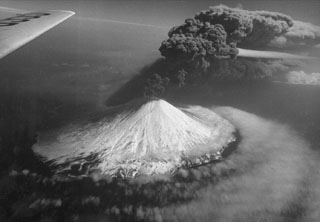
The Kamchatkan Volcanic Eruption Response Team notes that Alaid is characterized by two types of eruptions: central crater eruptions and lateral eruptions. Central crater eruptions are stronger and more dangerous then the lateral ones. The strongest central crater eruptions of Alaid were in February 1793, June 1854, July 1860, 1894, and April 1981. The April 1981 eruption sent an ash plume to 8,000-9,000 m altitude that extended for more than 1,500 km (SEAN 06:04 and 06:05). Two eruptions in 1933-1934 and 1972 (CSLP Cards nos. 1405, 1406, 1410, and 1518) ejected ash columns 3 km high.
Satellite imagery indicated possible activity in March 1982 (SEAN 07:03 and 12:04), 3 December 1996 (BGVN 21:12), and 23 August 1997 (BGVN 22:09).
Geological Summary. The highest and northernmost volcano of the Kuril Islands, Alaid is a symmetrical stratovolcano when viewed from the north, but has a 1.5-km-wide summit crater that is breached open to the south. This basaltic to basaltic andesite volcano is the northernmost of a chain constructed west of the main Kuril archipelago. Numerous pyroclastic cones are present the lower flanks, particularly on the NW and SE sides, including an offshore cone formed during the 1933-34 eruption. Strong explosive eruptions have occurred from the summit crater beginning in the 18th century. Reports of eruptions in 1770, 1789, 1821, 1829, 1843, 1848, and 1858 were considered incorrect by Gorshkov (1970). Explosive eruptions in 1790 and 1981 were among the largest reported in the Kuril Islands.
Information Contacts: Anastasia Tranbenkova, Kamchatka Volcanic Eruptions Response Team (KVERT), a cooperative program of the Institute of Volcanic Geology and Geochemistry, Far East Division, Russian Academy of Sciences, Piip Ave. 9, Petropavlovsk-Kamchatsky, 683006, Russia, the Kamchatka Experimental and Methodical Seismological Department (KEMSD), GS RAS (Russia), and the Alaska Volcano Observatory (USA); Alaska Volcano Observatory (AVO), a cooperative program of the U.S. Geological Survey, 4200 University Drive, Anchorage, AK 99508-4667, USA (URL: http://www.avo.alaska.edu/), the Geophysical Institute, University of Alaska, PO Box 757320, Fairbanks, AK 99775-7320, USA, and the Alaska Division of Geological and Geophysical Surveys, 794 University Ave., Suite 200, Fairbanks, AK 99709, USA.