Report on Whakaari/White Island (New Zealand) — March 2004

Bulletin of the Global Volcanism Network, vol. 29, no. 3 (March 2004)
Managing Editor: Richard Wunderman.
Whakaari/White Island (New Zealand) Eruptions ceased in about 2002; crater lake rising
Please cite this report as:
Global Volcanism Program, 2004. Report on Whakaari/White Island (New Zealand) (Wunderman, R., ed.). Bulletin of the Global Volcanism Network, 29:3. Smithsonian Institution. https://doi.org/10.5479/si.GVP.BGVN200403-241040
Whakaari/White Island
New Zealand
37.52°S, 177.18°E; summit elev. 294 m
All times are local (unless otherwise noted)
An April 2004 note from New Zealand geothermal geologist Ashley Cody noted that White Island had essentially ceased its eruptive episode since about 2002, when it began to emit only very weak gas (lacking ejecta). Accordingly, compared to several years ago, there has been little to report about it. However, the Institute of Geological & Nuclear Sciences (GNS) still monitors White Island seismically, and with the Geonet web camera (visible real-time on the net). This report contains a summary of their brief reports. An issue of current interest is the continued growth of the crater lake. Crater lake growth was previously reported in February and August 2003 (BGVN 28:02 and 28:08).
GNS reports warned that "should there be no significant eruptive activity within the next 18-24 months and the lake continues to fill, it may reach overflow level. In this situation water may overflow into drainage channels on Peg 12 Flat, S of the 1978/90 Crater Complex, and these channels may further erode . . . ."
Steve O'Meara of Volcano Watch International visited White Island on 8 February 2004 (figure 44) and noted considerably weaker fumarolic activity than during an earlier trip in 2000 (figure 45). Hydrothermal activity, though diminished, was still taking place in the crater and steam often lifted off the lake's surface, which effervesced. Scum was weakly present, especially around the lake's edges, but he did not see as much as during his 2000 visit. Volcanic bombs and explosion debris surrounded the crater. Although O'Meara's professionally-guided tour was conducted skillfully and with genuine regard for safety, he expressed concern about a sudden eruption from the lake catching onlookers off guard.
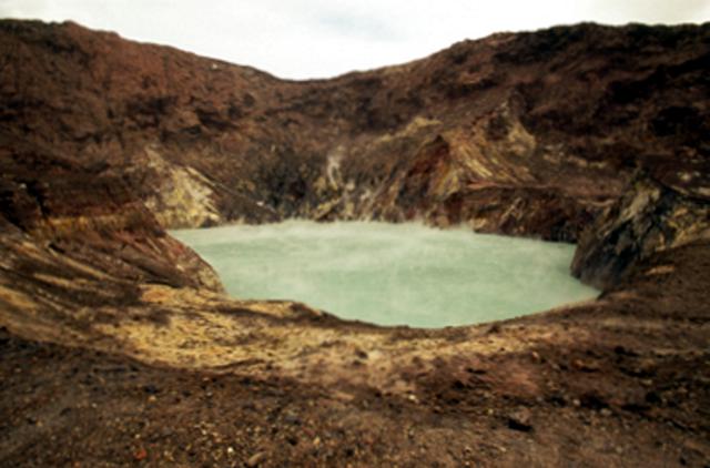 |
Figure 44. The rim of White Island's main crater taken looking W on 8 February 2004, showing the crater lake and the top of the E rim. Observers noted a small fresh landslide in the far crater wall (to the right of the fumaroles). Courtesy of Steve and Donna O'Meara, Volcano Watch International. |
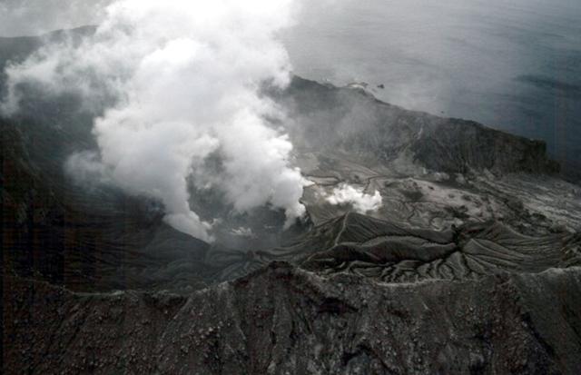 |
Figure 45. A wide-angle aerial shot of White Island taken 5 January 2000 amid much more vigorous degassing than present in February 2004. The then smaller, but more steam-covered crater lake appears in the center of the photo, directly behind the high point along the crater rim in the foreground. Courtesy of Steve and Donna O'Meara, Volcano Watch International. |
A 13 February 2004 report from the GNS stated that heavy rainfall on White Island during the past few weeks triggered many small landslides inside the crater rim. They went on to note that the lake continued to fill steadily and last week all of the temporary marker posts were submerged or had washed into the lake. This week, GNS volcanologists had visited the island to install six more survey posts inside the main crater, so changes in the lake's level could continue to be monitored. The lake temperature was 57°C, similar to values measured during the last six months. A 26 March report noted a decrease in the rate of rainfall and consequent drop in the rate of filling of the crater lake. GNS reports on 2 April and 26 March also mentioned minor seismic activity, which was described in more detail in a 19 March report as "including a few very small, discrete earthquakes but no volcanic tremor."
The GNS report for 30 April 2004 stated that "seismic and hydrothermal activity at White Island remain at a low level. The crater lake was then [12-]13.6 m below the level at which it will overflow. White Island also remains at Alert Level 1 (some signs of volcano unrest)." An overview of late 2002-early 2004 GNS data appears on table 11. There were no HIGP-MODIS thermal alert warnings for White Island over the 12 months to April 2004.
Table 11. A summary of the Institute of Geological & Nuclear Sciences (GNS) reports discussing White Island, October 2002 to April 2004. Courtesy of GNS.
| Month | Seismicity | Emission levels | Comment |
| Oct 2002 | -- | 63 metric tons of SO2 / day (t/d) | -- |
| Nov 2002 | Minor weak volcanic tremor | Weak steam / gas emissions | -- |
| Dec 2002 | Minor weak volcanic tremor | Weak steam / gas emissions; 112 t/d SO2 | -- |
| Jan 2003 | Moderate/weak volcanic tremor | Weak steam / gas emissions | -- |
| Feb 2003 | Low / minor volcanic tremor | Minor weak steam / gas emissions; 269 t/d SO2 | Increased tremor (with exception of 17 Feb) |
| Mar 2003 | Low levels of weak tremor | Low steam / gas emissions; 267 t/d SO2 | -- |
| Apr 2003 | Low / negligible | Weak / very weak steam / gas plumes | Active vent flooded, reducing emissions and seismicity |
| May 2003 | Very low | Unchanged | -- |
| Jun 2003 | Intermittent low-level activity | Minor steam / gas plume | -- |
| Jul 2003 | Very low | Plume no longer visible | Light green water, 30 m below rim; 58°C. Fumaroles 101-114°C |
| Aug 2003 | Low | -- | Water 53°C, 300 m long lake. Active monitoring of water level begins. |
Geological Summary. The uninhabited Whakaari/White Island is the 2 x 2.4 km emergent summit of a 16 x 18 km submarine volcano in the Bay of Plenty about 50 km offshore of North Island. The island consists of two overlapping andesitic-to-dacitic stratovolcanoes. The SE side of the crater is open at sea level, with the recent activity centered about 1 km from the shore close to the rear crater wall. Volckner Rocks, sea stacks that are remnants of a lava dome, lie 5 km NW. Descriptions of volcanism since 1826 have included intermittent moderate phreatic, phreatomagmatic, and Strombolian eruptions; activity there also forms a prominent part of Maori legends. The formation of many new vents during the 19th and 20th centuries caused rapid changes in crater floor topography. Collapse of the crater wall in 1914 produced a debris avalanche that buried buildings and workers at a sulfur-mining project. Explosive activity in December 2019 took place while tourists were present, resulting in many fatalities. The official government name Whakaari/White Island is a combination of the full Maori name of Te Puia o Whakaari ("The Dramatic Volcano") and White Island (referencing the constant steam plume) given by Captain James Cook in 1769.
Information Contacts: Institute of Geological & Nuclear Sciences (GNS), Private Bag 2000, Wairakwi, New Zealand (URL: http://www.gns/cri.nz); GeoNet, a project sponsored by the New Zealand Government through these agencies: Earthquake Commission (E.C.), Geological & Nuclear Sciences (GNS), and Foundation for Research, Science & Technology (FAST). Geonet can be contacted at the above GNS address (their URL: http://www.geonet.org.nz/contact.htm); Steve and Donna O'Meara, Volcano Watch International, PO Box 218, Volcano, HI 96785.