Report on Ambrym (Vanuatu) — May 2004
Bulletin of the Global Volcanism Network, vol. 29, no. 5 (May 2004)
Managing Editor: Richard Wunderman.
Ambrym (Vanuatu) Lava lake active; ash plume in MODIS images
Please cite this report as:
Global Volcanism Program, 2004. Report on Ambrym (Vanuatu) (Wunderman, R., ed.). Bulletin of the Global Volcanism Network, 29:5. Smithsonian Institution. https://doi.org/10.5479/si.GVP.BGVN200405-257040
Ambrym
Vanuatu
16.25°S, 168.12°E; summit elev. 1334 m
All times are local (unless otherwise noted)
Ambrym (last reported in BGVN 29:03) exhibited high levels of activity in March and April 2004. During March, an active lava lake was present in Mbwelesu crater, one of the active summit craters. As of 27 March, there were reports that the people of Craig Cove in West Ambrym were suffering from the effects of the ongoing volcanic eruption on the island. Gas and acidic rainfall from the active vents on the volcano were threatening to destroy the local food gardens. The island was still recovering from the effects of Cyclone Ivy, which caused widespread damage two weeks earlier; the added affects of the eruption prompted Vanuatu's leaders to request emergency relief assistance from national and local authorities.
As of 3 April, reports confirmed by the Darwin VAAC and J. Seach described continuing lava lake activity at Ambrym. On 27 April, a large ash plume was recorded drifting 150 km NW of the volcano, passing the northern tip of Malekula Island and almost reaching Malo Island. Eruptions were still continuing up to 2 May.
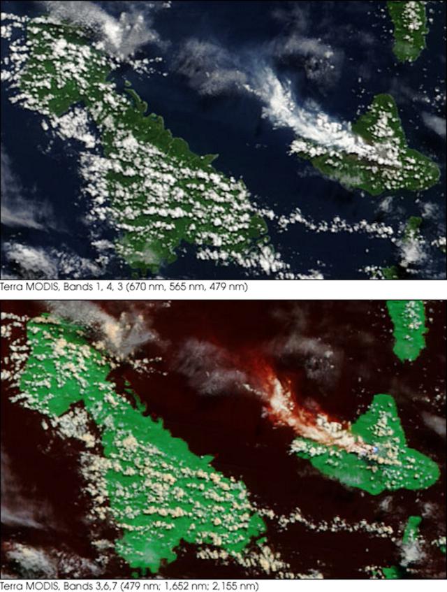
NASA's Earth Observatory posted two images of Ambrym and its plume as they appeared on 27 April 2004 (figure 11). The pair of images came from the Moderate Resolution Imaging Spectroradiometer (MODIS) on the Terra satellite. A large plume of volcanic ash blew westward from the volcano, which appears at the center right edge of figure 11 (top). The plume was mixing with clouds, and was more apparent as a bright, reddish orange color in the false-color image (below). Figure 11 (bottom) shows a wider area at the same spatial resolution.
 |
Figure 11. Ambrym volcano in two MODIS images (top and bottom). See text for discussion. Image courtesy Jeff Schmaltz, MODIS Rapid Response Team, NASA-GSFC. |
Geological Summary. Ambrym, a large basaltic volcano with a 12-km-wide caldera, is one of the most active volcanoes of the New Hebrides Arc. A thick, almost exclusively pyroclastic sequence, initially dacitic then basaltic, overlies lava flows of a pre-caldera shield volcano. The caldera was formed during a major Plinian eruption with dacitic pyroclastic flows about 1,900 years ago. Post-caldera eruptions, primarily from Marum and Benbow cones, have partially filled the caldera floor and produced lava flows that ponded on the floor or overflowed through gaps in the caldera rim. Post-caldera eruptions have also formed a series of scoria cones and maars along a fissure system oriented ENE-WSW. Eruptions have apparently occurred almost yearly during historical time from cones within the caldera or from flank vents. However, from 1850 to 1950, reporting was mostly limited to extra-caldera eruptions that would have affected local populations.
Information Contacts: John Seach, PO Box 4025, Port Vila, Vanuatu (URL: http://www.volcanolive.com/); Darwin VAAC (URL: http://www.bom.gov.au/info/vaac/); Jeff Schmaltz, MODIS Rapid Response Team, NASA-GSFC; Holli Riebeek, NASA Earth Observatory (URL: https://earthobservatory.nasa.gov/).

