Report on Awu (Indonesia) — May 2004
Bulletin of the Global Volcanism Network, vol. 29, no. 5 (May 2004)
Managing Editor: Richard Wunderman.
Awu (Indonesia) Great Sangihe Island stratovolcano erupts dome in June; ~27,000 evacuated
Please cite this report as:
Global Volcanism Program, 2004. Report on Awu (Indonesia) (Wunderman, R., ed.). Bulletin of the Global Volcanism Network, 29:5. Smithsonian Institution. https://doi.org/10.5479/si.GVP.BGVN200405-267040
Awu
Indonesia
3.689°N, 125.447°E; summit elev. 1318 m
All times are local (unless otherwise noted)
A dome-extruding eruption occurred in the previouly lake-bearing summit crater of Mount (Gunung) Awu, a stratovolcano in Northern Indonesia off the N end of the island of Sulawesi (Celebes). Details of the eruption are still emerging, but an early dome had clearly extruded by 2 June 2004 (figure 1).
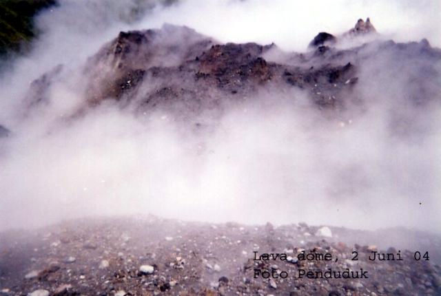 |
Figure 1. A close up of Awu's new dome as it appeared amid loose tephra and through a steam-laden atmosphere on 2 June 2004, soon after emplacement began. Courtesy Penduduk. |
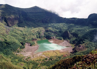
Prior to the eruption the crater contained a green lake. Before 1992, water volume was 35,000 x 103 m 3, but it decreased continuously, and in 2003, only 50 x 103 m 3 remained. Research carried out in 1993-1995 attributed the water loss to active faulting beneath the crater. Water inside the crater was of great concern because of its potential to produce lahars that could threaten settlements around Awu. Prior to the eruption, thick vegetation covered the crater's inner and outer rims.
Awu's previous eruption took place 12 August 1966. It took 39 lives, injured more than 1,000, and forced ~11,000 evacuations.
Signs of Awu threatening to erupt became clear mid-May 2004. They included a 15 May (felt, I MMI) tectonic earthquake, followed by two volcanic earthquakes. On 16 May, there were 12 volcanic earthquakes recorded, events interpeted as a signs of fluid moving up, and supported by the appearence of tremor with peak-to-peak amplitude of 8 mm. A gas plume rose 75 m above the crater's rim. On 17 May there were 4 volcanic earthquakes; peak-to-peak tremor amplitudes had dropped to 5 mm. This pattern continued through 18 May, with the number of volcanic earthquakes typically standing at ~6 and tremor amplitudes at 5 mm. The S minus P (S - P) times dropped from 2.0-1.75 sec to 0.5 sec, suggesting a shallower earthquake source, a possible indication of stress moving towards the surface.
In addition to the above observations, VSI scientists regarded the shortest historical repose time at Awu volcano as 25 years, an interval that had passed since the last eruption, and this became an additional reason for raising the alert level on 18 May.
Figure 1, a photo from the VSI website shows a close-up of a dome on 2 June 2004 with intense steam escaping, indicating that at least portions of a dome had emerged by that time. In figure 1, the dome and surrounding tephra predominanly appear as gray, darker-colored spines and angular blocks and fragments, but occasional clasts of large white fragments, presumably pumice, lie sprinkled across the surface.
Seismicity increased on 4-5 June during 2330-0130 when more than 30 shallow volcanic (Type A) earthquakes occurred. In contrast, typical May seismicity only included one earthquake per day. On 5 June during 1000-1300, instruments recorded 85 earthquakes. On 6 June during 0200-0430, they recorded 50; and during 0900-1010, they recorded 2-3 earthquakes per minute. Tremor followed, with maximum peak-to-peak amplitude of 24 mm. The hazards status quickly increased to its highest level ('IV,' WITA).
At 1230 on 6 June, explosion earthquakes of small size occurred, followed by a rain of thin ash, which fell to the N. Visible white ash reached 500-750 m above the summit. An explosion sent ash 1 km above the crater rim, and the ash fell around the summit. Tremor prevailed until 2000, with maximum amplitude of 5 mm. At this point, 20,000 residents had already been evacuated.
Seismicity increased on 7 June; during the period 0000 to 0800 hours seismometers recorded 165 deep volcanic earthquakes, 18 shallow volcanic earthquakes, and continuous volcanic tremor-amplitude maxima exceeded 46 mm.
At 1117 on 7 June, an eruption began at 1800 hours, with ash plumes rising 1 km above the summit. After the eruption on 7 June, seismic signals similar to tremor occured (at 1807), with continuous, peak-to-peak amplitudes of about 12-45 mm (maximum).
During 7-8 June from 2000 to 0600, visual observers noted that 500- to 700-m-high ash clouds still hung over the summit. For the interval 0600-0600 8-9 June, VSI reported, "All day long there were many explosions." In additon, five major explosions were noted, at 1510, 1630, and 1730 on 8 June, and at 0606 and 0910 on 9 June. Presumably due to each of those larger outbursts, dark gray ash plumes rose up 1-2 km above the summit.
Ash thickness at Tahuna was about 0.5-1.5 mm. Beginning on 8 June 2004 at 0800, Tahuna airport was closed. VSI noted that the ash rain could have reached Tabukan Utara and part of Kendahe, caused by the wind to the SW.
At 0529 on 10 June, Awu began a sustained eruption, described as the climax, lasting 34 minutes (figure 2). That event sent a column of gray to black ash to 3 km above the summit. The outburst was accompanied by low rumbling sounds and tephra.
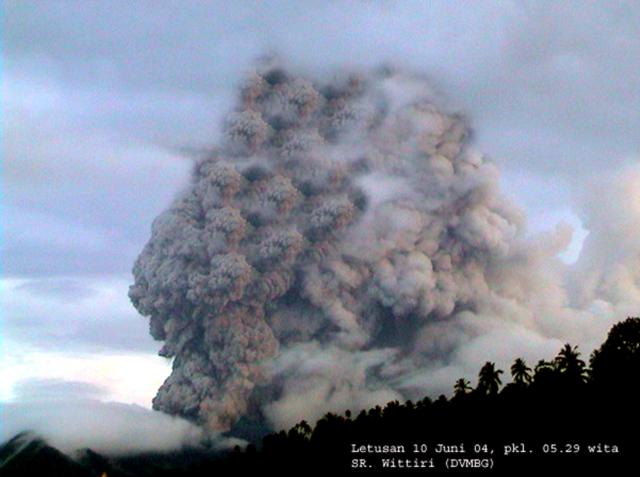 |
Figure 2. Ash plume at Mount Awu at 0529 on 10 June 2004. Courtesy of Wittiri, VSI, Directorate of Volcanology and Geological Hazard Mitigation. |
By 11 June, explosions and seismicity decreased drastically, with tremor amplitudes of only 2-3 mm. Until 13 June VSI recorded no deep volcanic earthquakes. At 0600 on 13 June authorities reduced the hazard status and some W- and ESE-flank residents returned home.
Figure 3 documents fresh deposits, the presumably new dome, and denuded vegetation. Ash generally fell to the ESE. During the first eruption, ash fell on Tahuna city and its vicinity with a thickness of 0.5-1 mm. Surrounding villages received ash deposits as follows: Lenganeng, 2 mm; Naha, 2 mm; Bahang, 1.5 mm; Kalakuhe, 1.5 mm; and Mala, 1.5 mm.
 |
Figure 3. Recent tephra deposited below the Mount Awu lava dome, 12 June 2004. For scale, note the backpack-clad person standing on fresh tephra and amid stripped vegetation in the right-central foregound. Courtesy of A. Solihin, VSI, Directorate of Volcanology and Geological Hazard Mitigation (DVMBG). |
Inspection of the crater at an undisclosed time revealed a lava dome 300 x 250 m in plan view and 40 m in height. It is uncertain whether these values represent an early dome (figure 1) or larger, later dome (figure 3).
On 14 June, observers saw a thin white plume rising 50-100 m above the crater. Beginning 17 June, the hazard status dropped to level II (Waspada). Following 18 June, seismicity declined, and instruments no longer recorded tremor. The latest Awu report, which discussed the interval 28 June-4 July, noted level II hazard status, plumes 50-200 m tall, and the observation of incandescent material, suggesting continued dome growth.
UN Reports. According to an 8 June report from the UN Office for the Coordination of Humanitarian Affairs, the evacuation process triggered by Awu's eruption started on the evening of 6 June and continued through at least 8 June. The total number of people expected to be evacuated was ~27,000 (12,065 from Tahuna, 5,690 from Kendahe, and 9,248 from Tabukan Utara). As of 8 June, 17,326 people had been evacuated. These displaced people were accommodated in government buildings, schools, and houses of prayer. The Directorate of Vulcanology strongly advised the temporary halting of flights from Manado (at the N end of Sulawesi Island) to Sangihe Island.
Geological Summary. The massive Gunung Awu stratovolcano occupies the northern end of Great Sangihe Island, the largest of the Sangihe arc. Deep valleys that form passageways for lahars dissect the flanks of the volcano, which was constructed within a 4.5-km-wide caldera. Powerful explosive eruptions in 1711, 1812, 1856, 1892, and 1966 produced devastating pyroclastic flows and lahars that caused more than 8000 cumulative fatalities. Awu contained a summit crater lake that was 1 km wide and 172 m deep in 1922, but was largely ejected during the 1966 eruption.
Information Contacts: Dali Ahmad, Volcanological Survey of Indonesia (VSI), Directorate of Volcanology and Geological Hazard Mitigation, Jalan Diponegoro 57, Bandung 40122, Indonesia (URL: http://www.vsi.esdm.go.id/); Office for the Coordination of Humanitarian Affairs (OCHA), United Nations, New York, NY 10017 USA.