Report on Anatahan (United States) — May 2004

Bulletin of the Global Volcanism Network, vol. 29, no. 5 (May 2004)
Managing Editor: Richard Wunderman.
Anatahan (United States) Seismicity, fresh lava in crater, satellite image of ash plume
Please cite this report as:
Global Volcanism Program, 2004. Report on Anatahan (United States) (Wunderman, R., ed.). Bulletin of the Global Volcanism Network, 29:5. Smithsonian Institution. https://doi.org/10.5479/si.GVP.BGVN200405-284200
Anatahan
United States
16.35°N, 145.67°E; summit elev. 790 m
All times are local (unless otherwise noted)
The first recorded historical eruption at Anatahan Island began on 10 May 2003 (BGVN 28:04-28:06 and 28:09). More volcanism accompanied increased seismicity beginning 30 March 2004 (BGVN 29:04). Lava was noted in the crater on 15 April. During an overflight on 24 April scientists reported fresh lava within the inner crater. Seismic activity increased abruptly at 1052 on 24 April, escalating to levels higher than recorded since summer 2003, and a moderate eruption initially produced a light ash cloud that rose to altitudes below 2 km. The cloud persisted for only a day or so.
The seismicity level increased further on 24 and 25 April. On 26 April, a flat-shaped dome was observed within the inner crater. On the evening of April 28, the seismicity level peaked, then decreased slowly to about 40% of its peak value by 29 May. That seismicity resulted from strombolian bursts every minute or so that ejected material some hundreds of meters out of the crater, and steam and ash to several hundred meters. After a two-day-long decrease, the seismicity surged on 30-31 May to double the value of the previous few days, resulting from more frequent small explosions (occurring every few tens of seconds) as well as increased tremor.
On 7 and 8 June a 100-km-long, light-colored plume of steam and ash blew W. This was reported by the U.S. Air Force Weather Agency based on Defense Meteorological Satellite Program (DMSP) satellite images (figure 12).
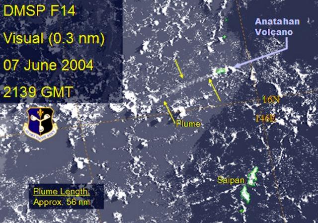 |
Figure 12. Visual (0.3 nm) image of plume from Anatahan volcano taken from Defense Meteorological Satellite Program satellite on 7 June 2004 at 2139 hours GMT (8 June 2004 at 0739 hours local time). Note that the plume length at this time, measured by the U.S. Air Force Weather Agency, was ~104 km (~56 nautical miles). Courtesy of Charles R. Holliday, U.S. Air Force Weather Agency. |
Juan Camacho of the Commonwealth of the Northern Mariana Islands Emergency Management Office (CNMI/EMO) visited the island on 10 June and reported an active spatter cone, from which continuous strombolian explosions threw material as high as 100 m every 10 seconds to one minute. By 15 June, the amplitude and number of discrete events appeared to have decreased slightly.
Geological Summary. The elongate, 9-km-long island of Anatahan in the central Mariana Islands consists of a large stratovolcano with a 2.3 x 5 km compound summit caldera. The larger western portion of the caldera is 2.3 x 3 km wide, and its western rim forms the island's high point. Ponded lava flows overlain by pyroclastic deposits fill the floor of the western caldera, whose SW side is cut by a fresh-looking smaller crater. The 2-km-wide eastern portion of the caldera contained a steep-walled inner crater whose floor prior to the 2003 eruption was only 68 m above sea level. A submarine cone, named NE Anatahan, rises to within 460 m of the sea surface on the NE flank, and numerous other submarine vents are found on the NE-to-SE flanks. Sparseness of vegetation on the most recent lava flows had indicated that they were of Holocene age, but the first historical eruption did not occur until May 2003, when a large explosive eruption took place forming a new crater inside the eastern caldera.
Information Contacts: Juan Takai Camacho and Ramon Chong, Commonwealth of the Northern Mariana Islands Emergency Management Office (CNMI/EMO), Saipan, MP 96950 USA (URL: http://www.cnmihsem.gov.mp/); Frank Trusdell, U.S. Geological Survey, Hawaiian Volcano Observatory (HVO), PO Box 51, Hawaii National Park, HI 96718, USA (URL: https://volcanoes.usgs.gov/nmi/activity/); Hawaii Volcano Observatory (HVO), U.S. Geological Survey (USGS), Hawaii National Park, HI 96718, USA (URL: https://volcanoes.usgs.gov/nmi/activity/)update.html); Charles R. Holliday, Air Force Weather Agency, Offutt Air Force Base, Nebraska 68113 USA.