Report on Veniaminof (United States) — June 2004

Bulletin of the Global Volcanism Network, vol. 29, no. 6 (June 2004)
Managing Editor: Richard Wunderman.
Veniaminof (United States) Ash emissions and seismic activity from mid-February through June 2004
Please cite this report as:
Global Volcanism Program, 2004. Report on Veniaminof (United States) (Wunderman, R., ed.). Bulletin of the Global Volcanism Network, 29:6. Smithsonian Institution. https://doi.org/10.5479/si.GVP.BGVN200406-312070
Veniaminof
United States
56.17°N, 159.38°W; summit elev. 2507 m
All times are local (unless otherwise noted)
After many years of quiescence, Veniaminof began exhibiting increased seismicity during September 2002 along with some possible low-level eruptive activity (BGVN 27:10). Variable seismicity contined to be recorded from October 2002 through mid-April 2003 accompanied by steam emissions from the intracaldera cone (BGVN 28:01 and 28:03). No additional signs of activity were noted until mid-February 2004.
Activity during February 2004. During the week of 15 February 2004, the Alaska Volcano Observatory (AVO) received several reports of small ash clouds rising ~ 30-90 m above the intracaldera cinder and spatter cone of Veniaminof. Residents of Perryville (~ 30 km S) reported a "black puff" of ash on 16 February, followed by strong steam emissions.
A pilot reported a small black ash cloud on 19 February. Satellite imagery from 2310 UTC (1410 AST) on 19 February showed a small, dark trail on the snow leading away from the intracaldera cone, possibly an intra-caldera ash deposit. Aerial photographs on 21 February showed distinct ash deposits (figure 8). No significant seismic activity or thermal anomalies were recorded during the week. Due to the lack of significant seismic activity beneath the volcano, AVO concluded that these small ash clouds were the result of minor explosions caused by the heating of ground water below the intracaldera cone. The Concern Color Code remained at Green.
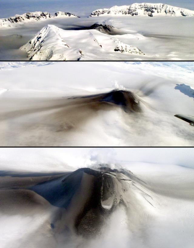 |
Figure 8. Photographs showing ash deposits in Mount Veniaminof's intracaldera zone taken on 21 February 2004. The top view is from the SW with the Cone Glacier and a caldera rim segment in the left foreground, the intracaldera cone in the center, and the NE caldera rim divided by the Crab Glacier in the background. The close-up photographs of the cone were taken while looking generally SE. Courtesy of Nathan Fratzke and Heidi Breon (Peninsula Airways). |
Satellite imagery on 22 February (figure 9) again showed very localized deposits within the ice-filled caldera. No additional signs of volcanic activity were visible on satellite imagery during 23-27 February, and there were no more reports of ash-plume sightings from observers. Seismicity remained at a low level, and the thermal signature of the intracaldera cone was unchanged from previous months.
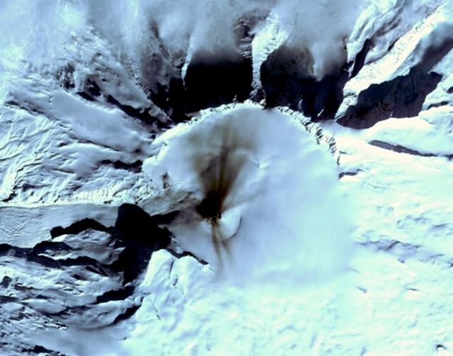 |
Figure 9. Image of Veniaminof from the Terra ASTER 15-m satellite (bands 3, 2, and 1) acquired on 22 February 2004 at 2158 UTC (1258 local time). This close-up view shows several ash bands in different directions suggesting multiple small ash eruptions with visible deposits largely confined within the 8- to 11-km-diameter caldera walls. Courtesy of AVO. |
Activity during April 2004. During the week of 11 April, several low-level episodes of volcanic tremor and small volcanic earthquakes were recorded. The tremor occurred in pulses lasting several minutes. This represented the strongest seismicity since early 2003 when the Concern Color Code was downgraded from Yellow to Green, although no significant changes in the thermal signature of the intracaldera cone were noted in satellite data.
Perryville residents reported that a steam emission, possibly containing a small amount of volcanic ash, was visible most of the day on 18 April. It became most vigorous at approximately 1730 ADT (0130 UTC on 19 April) when it rose to ~ 460-610 m above the intracaldera cone (~ 2,590-2,740 m altitude). Starting at approximately 1130 ADT on 19 April, tremor and earthquake levels increased, albeit to lower levels than those during the previous week. The Color Code was upgraded to Yellow. During subsequent days in the week of 19 April there was a marked decrease in the episodes of low-level volcanic tremor and small volcanic earthquakes. No emissions were reported.
On the afternoon and evening of 25 April, more than 25 small steam and ash emissions were seen during an 8-hour period, producing clouds that rose ~ 300-610 m above the active cone. During the week of 25 April activity was characterized by small, intermittent ash emissions, low-level volcanic tremor, and small volcanic earthquakes. Small ash emissions were observed during periods of clear weather on 28 April. Ash clouds rose ~ 0.3-1 km above the active cone, and at times were observed drifting for distances of ~ 16 km. Seismic activity fluctuated but remained above background levels.
Activity during May 2004. The week of 2 May was characterized by small, intermittent ash emissions, low-level volcanic tremor, and small volcanic earthquakes. Small ash emissions were observed during periods of clear weather on 1-3 May. Ash clouds rose ~ 300-610 m above the active cone. No systematic visual observations of ash plumes were made during 4-18 May due to the camera-monitoring system being repaired, though residents reported continued activity on 5 May. However, the observed seismicity was similar to that recorded in the previous week, suggesting that ash emissions continued. Satellite imagery showed ash deposits on the snow to distances of ~ 8 km from the vent, and a pilot reported ash as far as 33 km from the cone.
There were no observations of ash emissions during the week of 9 May, when cloudy conditions obscured the volcano. Seismic activity was more intermittent and lower in amplitude than in previous weeks; however, seismicity suggested that ash emissions occasionally occurred. Unrest during the week of 16 May was characterized by moderate levels of intermittent volcanic tremor, which was similar to the seismic signals recorded in association with the small ash emissions of 25 and 28 April and 1-3 May. On 18 May, a pilot reported an ash plume rising 300-900 m above the volcano's summit (2.8-3.4 km altitude) and extending ~32 km NE. Cloudy conditions obscured observation by satellite.
Bursts of volcanic tremor continued during the week of 24 May. Activity in general was lower than that of the previous week, but sequences of tremor accompanying ash emissions continued to be observed. Clear views of the volcano on 26 May showed weak steam and low ash emissions emanating from the intracaldera cone. Most of these emissions did not rise higher than the active cone (2,507 m elevation). Satellite data acquired on 26 May showed ash deposits in the N and SE portions of the caldera. The only significant ash emissions observed during the week of 31 May occurred the evening of 30 May into the morning of 31 May; none appeared to have exceeded 3,000 m altitude. Clear views earlier on 30 May showed steam emissions from near the base of the intracaldera cone, which rarely rose above the top of the cone. No activity was observed in satellite data as the volcano was largely obscured by clouds.
Activity during June 2004. Bursts of volcanic tremor continued throughout June, and were thought to be indicative of small, low-level ash emissions. Clouds obscured the volcano for most of the month, making observations difficult. The only ash emissions observed in the week of 7 June occurred the evening of 11 June. None appeared to have exceeded 3,000 m altitude. On 16 June at 2350, a pilot observed an ash cloud that rose ~ 2,650 m altitude. This ash cloud was also observed in satellite imagery. Low-level activity continued during the week of 28 June, with episodes of low-level tremor and small volcanic earthquakes occurring regularly on 30 June. Observations made by AVO during an aerial overflight of the active cone on 27 June indicated small amounts of dark ash on the surface of the snow within the ice-and-snow-filled caldera. The ash, although apparently thin, covered most of the snow surface inside the caldera.
Geological Summary. Veniaminof, on the Alaska Peninsula, is truncated by a steep-walled, 8 x 11 km, glacier-filled caldera that formed around 3,700 years ago. The caldera rim is up to 520 m high on the north, is deeply notched on the west by Cone Glacier, and is covered by an ice sheet on the south. Post-caldera vents are located along a NW-SE zone bisecting the caldera that extends 55 km from near the Bering Sea coast, across the caldera, and down the Pacific flank. Historical eruptions probably all originated from the westernmost and most prominent of two intra-caldera cones, which rises about 300 m above the surrounding icefield. The other cone is larger, and has a summit crater or caldera that may reach 2.5 km in diameter, but is more subdued and barely rises above the glacier surface.
Information Contacts: Alaska Volcano Observatory (AVO), a cooperative program of a) U.S. Geological Survey, 4200 University Drive, Anchorage, AK 99508-4667, USA (URL: http://www.avo.alaska.edu/), b) Geophysical Institute, University of Alaska, PO Box 757320, Fairbanks, AK 99775-7320, USA, and c) Alaska Division of Geological & Geophysical Surveys, 794 University Ave., Suite 200, Fairbanks, AK 99709, USA.