Report on Erta Ale (Ethiopia) — August 2004
Bulletin of the Global Volcanism Network, vol. 29, no. 8 (August 2004)
Managing Editor: Richard Wunderman.
Erta Ale (Ethiopia) Declining thermal output from small lava lake since early 2003
Please cite this report as:
Global Volcanism Program, 2004. Report on Erta Ale (Ethiopia) (Wunderman, R., ed.). Bulletin of the Global Volcanism Network, 29:8. Smithsonian Institution. https://doi.org/10.5479/si.GVP.BGVN200408-221080
Erta Ale
Ethiopia
13.601°N, 40.666°E; summit elev. 585 m
All times are local (unless otherwise noted)
Field expeditions during November 2003 and February 2004 found that the molten-surfaced lave lake at Erta Ale had almost disappeared (BGVN 29:02). HIGP MODIS Thermal Alerts satellite observations of infrared emissions from the volcano during January 2001-March 2004 confirmed the declining activity levels. MODIS acquires an image of subaerially active volcanoes such as Erta Ale an average of four times in each 48-hour period, twice by day and twice by night. Elevated levels of thermal emission (e.g. active lava flows) are detected by the MODVOLC algorithm, and collated (at http://modis.higp.hawaii.edu).
The level of radiative power output from the summit of Erta Ale (figure 13) averaged 75 MW during 2001 and 2002, dropped significantly during the first five months of 2003, and even further between June and November 2003 to a level beneath the detection limit of the algorithm (~ 10 MW). With the exception of one isolated thermal spike in December 2003, this decline in thermal output continued up to the time of the MODIS report (March 2004). Between December 2002 and March 2004, the average rate of power loss fell to approximately 30 MW. The field-expedition reports corroborated the MODIS observations that a substantial decline in the level of lava-lake activity at Erta Ale occurred since January 2003.
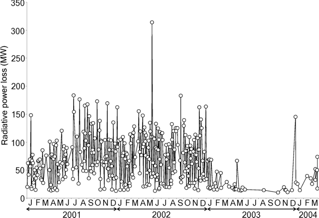 |
Figure 13. Level of radiative power output from the summit of Erta Ale, January 2001-March 2004. Data courtesy HIGP MODIS thermal alert system. |
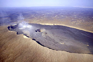
Observations during November-December 2003. Between 22 November and 6 December 2003, Joshua Jones and Roberto Carniel recorded continuous seismic, thermal, and acoustic data during fieldwork at the volcano. During this time they took several digital photographs showing a small but active lava lake in the southern crater of the summit caldera, and overflows were observed into the southern crater floor. The lava lake was approximately 20 m across.
References. Wright, R., and Flynn, L.P., 2004, Space-based estimate of the volcanic heat flux into the atmosphere during 2001 and 2002: Geology, v. 32, p. 189-192.
Geological Summary. The Erta Ale basaltic shield volcano in Ethiopia has a 50-km-wide edifice that rises more than 600 m from below sea level in the Danakil depression. The volcano includes a 0.7 x 1.6 km summit crater hosting steep-sided pit craters. Another larger 1.8 x 3.1 km wide depression elongated parallel to the trend of the Erta Ale range is located SE of the summit and is bounded by curvilinear fault scarps on the SE side. Basaltic lava flows from these fissures have poured into the caldera and locally overflowed its rim. The summit caldera usually also holds at least one long-term lava lake that has been active since at least 1967, and possibly since 1906. Recent fissure eruptions have occurred on the N flank.
Information Contacts: Rob Wright and the HIGP MODIS Thermal Alerts Team, Hawaii Institute of Geophysics and Planetology, University of Hawaii, 2525 Correa Road, Honolulu, HI 96822, USA (URL: http://modis.hgip.hawaii.edu/); Joshua Jones, Department of Earth & Space Sciences, Box 351310, Seattle, WA 98195-1310, USA; Roberto Carniel, Dipartimento di Georisorse e Territorio, University of Udine - via Cotonificio, 114 - 33100 Udine, Italy.