Report on Soufriere Hills (United Kingdom) — September 2004

Bulletin of the Global Volcanism Network, vol. 29, no. 9 (September 2004)
Managing Editor: Richard Wunderman.
Soufriere Hills (United Kingdom) Generally low activity; small lake forms in summit crater
Please cite this report as:
Global Volcanism Program, 2004. Report on Soufriere Hills (United Kingdom) (Wunderman, R., ed.). Bulletin of the Global Volcanism Network, 29:9. Smithsonian Institution. https://doi.org/10.5479/si.GVP.BGVN200409-360050
Soufriere Hills
United Kingdom
16.72°N, 62.18°W; summit elev. 915 m
All times are local (unless otherwise noted)
According to reports issued by the Montserrat Volcano Observatory (MVO), activity at Soufrière Hills volcano remained low during 21 May-10 September 2004, becoming slightly elevated from 10 September-15 October 2004. Minor events during this period included mudflows, rockfalls, and several small, shallow earthquakes originating at upper regions of the lava dome and conduit.
On 21 May 2004, heavy rainfall caused large mudflows for about two hours (1420 to 1636). The mudflows traveled into the Belham Valley, an area within the exclusion zone on the volcano's NW side, flooding the entire width of the valley floor at Belham bridge. Scientists from MVO noted that at the peak of flow, standing waves of mud reached 2 m high. Intense rains on 25 July, 14 September, and 16 September again caused up-slope erosion and mudflows descended into the Belham Valley.
Surface water from the intense rain of 21 May percolated into the subsurface of the hot dome and vent complex, converting into steam. Steam venting may have initiated the 44 mixed earthquakes recorded the week of 21-28 May (table 56). The earthquakes were short in duration (~ 30 seconds each), and their amplitude decay characteristics suggested that they originated at shallow depths within the remnant dome and at the top of the conduit. The term 'remnant dome' refers to the fact that the late May 2004 dome was considerably reduced in size compared to the dome of about a year before, in large part because of major collapse events on 12 July 2003 and 3 March 2004.
Table 56. Seismicity recorded at Soufrière Hills, 21 May to 15 October 2004. Courtesy of Montserrat Volcano Observatory.
| Date | Activity Level | Hybrid | Mixed | Volcano-tectonic | Long-period | Rockfall |
| 21 May-28 May 2004 | Low | 7 | 44 | -- | -- | -- |
| 28 May-04 Jun 2004 | Low | 4 | 16 | -- | -- | -- |
| 04 Jun-11 Jun 2004 | Low | 3 | 9 | -- | -- | -- |
| 11 Jun-18 Jun 2004 | Low | 5 | -- | -- | -- | 10 |
| 18 Jun-25 Jun 2004 | Low | 5 | -- | 6 | -- | 15 |
| 25 Jun-02 Jul 2004 | Low | 5 | -- | 6 | 2 | 8 |
| 02 Jul-09 Jul 2004 | Low | 8 | -- | 4 | -- | 10 |
| 09 Jul-16 Aug 2004 | Low | 6 | -- | 1 | 1 | 5 |
| 16 Jul-23 Jul 2004 | Low | 7 | -- | -- | -- | 7 |
| 23 Jul-30 Jul 2004 | Low | 2 | -- | -- | -- | 8 |
| 30 Jul-06 Aug 2004 | Low | 1 | -- | -- | -- | 8 |
| 06 Aug-13 Aug 2004 | Low | 1 | -- | -- | -- | 3 |
| 13 Aug-20 Aug 2004 | Low | 1 | -- | 1 | -- | 1 |
| 20 Aug-27 Aug 2004 | Low | 1 | -- | -- | -- | 1 |
| 27 Aug-03 Sep 2004 | Low | 2 | -- | -- | -- | -- |
| 03 Sep-10 Sep 2004 | Low | -- | -- | 1 | -- | 2 |
| 10 Sep-17 Sep 2004 | slightly elevated | 14 | -- | -- | 1 | 1 |
| 17 Sep-24 Sep 2004 | slightly elevated | 8 | -- | -- | 2 | 2 |
| 24 Sep-01 Oct 2004 | slightly elevated | 8 | -- | -- | 1 | 3 |
During 18-25 June, winds blew the volcanic plume NE, and the clouds over the volcano's summit lifted, making the tallest remnants of the dome complex visible for the first time since 7 May. Observers noted a loss of material from the upper regions of the dome due to rockfalls.
Later, on 30 August, MVO personnel on an observation flight discovered a small brown pond within the dome complex (figure 5). This pond was the first seen on the volcano since the beginning of its eruption in 1995. The pond lies in a small crater formed by an explosion and dome collapse on 3 March 2004 (figure 57). It probably developed following the cooling of deposits within the crater, and after recent heavy rainfall.
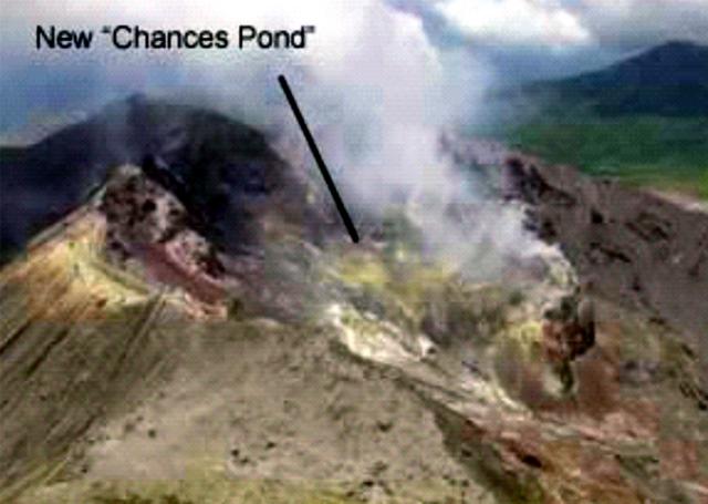 |
Figure 57. A view looking NW into English's crater during the week of 27 August 2004. Water collected in an explosion pit formed on 3 March 2004. The small brown water body became known as 'Chances pond.' Photo courtesy of Montserrat Volcano Observatory. |
Sulfur dioxide (SO2) emissions typically remained low throughout the period. Measured fluxes ranged between about 90 and 1,100 metric tons per day (table 57). Moderate fluctuations occurred during 21-24 May (225-922 metric tons/day) and 7-11 June (169-788 metric tons/day). During 2-9 July, SO2 emissions dropped to the lowest levels since the collapse event of 12-13 July 2003, and fell even lower during the weeks of 30 July and 17 September.
Table 57. SO2 gas flux estimates made at Soufrière Hills, 21 May to 15 October 2004. Courtesy of Montserrat Volcano Observatory.
| Date | SO2 emissions (tons/day) |
| 21 May-28 May 2004 | 225-922 |
| 28 May-04 Jun 2004 | 179-496 |
| 04 Jun-11 Jun 2004 | 169-788 |
| 11 Jun-18 Jun 2004 | 240-477 |
| 18 Jun-25 Jun 2004 | -- |
| 25 Jun-02 Jul 2004 | 177-364 |
| 02 Jul-09 Jul 2004 | 120-160 |
| 09 Jul-16 Aug 2004 | 222-243 |
| 16 Jul-23 Jul 2004 | 170-400 |
| 23 Jul-30 Jul 2004 | 175-300 |
| 30 Jul-06 Aug 2004 | 90-280 |
| 06 Aug-13 Aug 2004 | 126-296 |
| 13 Aug-20 Aug 2004 | 200-622 |
| 20 Aug-27 Aug 2004 | 175-311 |
| 27 Aug-03 Sep 2004 | 240-456 |
| 03 Sep-10 Sep 2004 | 175-405 |
| 10 Sep-17 Sep 2004 | 130-250 |
| 17 Sep-24 Sep 2004 | 87-454 |
| 24 Sep-01 Oct 2004 | 200-540 |
| 01 Oct-08 Oct 2004 | 187-1144 |
| 08 Oct-15 Oct 2004 | 156-553 |
Measurements of expansion made by dilatometers embedded on either side of the Soufriere Hills edifice suggested that in July, the volcano changed from contraction to slight expansion.
Geological Summary. The complex, dominantly andesitic Soufrière Hills volcano occupies the southern half of the island of Montserrat. The summit area consists primarily of a series of lava domes emplaced along an ESE-trending zone. The volcano is flanked by Pleistocene complexes to the north and south. English's Crater, a 1-km-wide crater breached widely to the east by edifice collapse, was formed about 2000 years ago as a result of the youngest of several collapse events producing submarine debris-avalanche deposits. Block-and-ash flow and surge deposits associated with dome growth predominate in flank deposits, including those from an eruption that likely preceded the 1632 CE settlement of the island, allowing cultivation on recently devegetated land to near the summit. Non-eruptive seismic swarms occurred at 30-year intervals in the 20th century, but no historical eruptions were recorded until 1995. Long-term small-to-moderate ash eruptions beginning in that year were later accompanied by lava-dome growth and pyroclastic flows that forced evacuation of the southern half of the island and ultimately destroyed the capital city of Plymouth, causing major social and economic disruption.
Information Contacts: Montserrat Volcano Observatory (MVO), Fleming, Montserrat, West Indies (URL: http://www.mvo.ms/).