Report on Montagu Island (United Kingdom) — September 2004
Bulletin of the Global Volcanism Network, vol. 29, no. 9 (September 2004)
Managing Editor: Richard Wunderman.
Montagu Island (United Kingdom) 1 October 2004 satellite image suggests a complex and ongoing eruption
Please cite this report as:
Global Volcanism Program, 2004. Report on Montagu Island (United Kingdom) (Wunderman, R., ed.). Bulletin of the Global Volcanism Network, 29:9. Smithsonian Institution. https://doi.org/10.5479/si.GVP.BGVN200409-390081
Montagu Island
United Kingdom
58.445°S, 26.374°W; summit elev. 1370 m
All times are local (unless otherwise noted)
A high-resolution image of Montagu island and volcano of the same name suggests the earlier recognized, ongoing eruption (BGVN 28:02; v. 29, no. 1 ) continued through at least 1 October 2004. On a NASA website, scientist James Garvin posted an image of the 1 October scene (figure 7). Imagery taken prior to late 2001 showed the island as entirely white. The new image deserves and requires considerable study, but some initial observations from James Garvin and Bulletin editors follow.
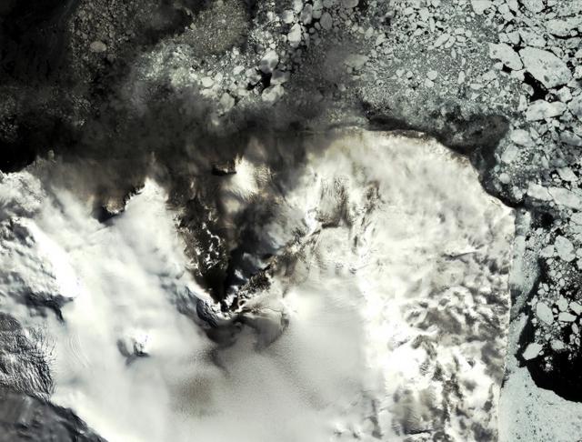 |
Figure 7. Montagu Island as imaged on 1 October 2004 by the IKONOS satellite. N is towards the top. The apex of the black zone of lava flows near the island's center presumably represents a vent within the summit crater. The distance from that spot to the coast is ~ 3 km. This image depicts numerous recent volcanogenic features. Montagu Island lies in the South Sandwich islands at the E edge of the Scotia plate, 2,600 km E of Cape Horn, ~ 1,000 km from the Antarctic circle, and ~ 3,500 km from the S pole. Courtesy of Space Imaging and James B. Garvin, NASA. |
The 1 October 2004 image shows the N flank of the central cone, Mount Belinda, emitting a NNE-drifting steam plume. Much of Montagu island sat amid a mosaic of floating ice. In contrast, on the previous image taken 7 December 2003 (BGVN 29:01), icebergs were sparse. Several square kilometers of sea ice on the island's lower right appears comparatively coherent and tightly butted against the island's margin. These changes may reflect sea-ice abundance during the S-hemisphere winter.
In addition, the higher detail in the new higher resolution image portrays a variety of patterns and features of volcanological significance that were absent or at least less clearly visible on earlier images. In the new image, the area of apparently continuous lava flows seems to have reached the island's N margin (a distance of ~ 3 km). On the 7 December 2003 image these flows had reached little more than 1 km in length and were considerably narrower, and stood alongside broad, dark swaths of SE- to E-directed ash deposits (BGVN 29:01). These latter ash deposits have become less apparent on the newer image, conceivably due to cover beneath winter's snowfall.
The newer image depicts the S-flank's upper slopes as containing much broader areas of darkened snow and ice. Some of the sea ice N of the previously mentioned lava flows also appears darkened. To the S of the Belinda summit lies a previously unseen, sinuously shaped 'beard,' presumably composed of darkened snow. Another newly visible feature, the black area to the NNW (upper left), presumably reveals lava flows emerging from beneath the ice. This zone of lava flows resides without clear connection to the conspicuous, larger, previously mentioned one flowing from higher up-slope. The black area to the NNW may thus be a new vent area. Alternatively, the black area may represent the spot where a longer sub-glacial lava flow transited some unknown distance beneath the ice and here melted its way to the surface. Another such area may reside on the NNE flanks, midway from the summit area and the coast. On the island's W (left) side exists a newly imaged network of broken ice. It could suggest an episode of fresh crevassing there.
Although the version shown in figure 7 has reduced resolution for print and web distribution, the full-resolution version of the IKONOS color image distributed by NASA has a resolution of 4 m per pixel and another version, 1 m per pixel (creating a 3.20 Mb image). James Garvin noted that dynamic processes such as those on remote, uninhabited islands, can be monitored from orbit, thereby serving to target more intensive field studies when they are justified. As such, IKONOS imaging of localities such as active eruptions involving ice-lava interactions, represents a new form of scientific exploration of planet Earth. The eruption has produced a 'natural laboratory' for studying lava-ice interactions relevant to the biology of extreme environments as well as to processes believed to be important on the planet Mars.
The IKONOS earth-imaging satellite launched in September 1999. IKONOS includes optical, radar, and infrared sensors. These can be combined in a variety of ways to accommodate a wide range of imagery applications (including stereo images).
Geographic terminology. The nomenclature of volcanic features on Montagu Island, particularly in regard to Mount Belinda, has been quite variable. Although the name Montagu has been applied to the major volcanic edifice forming the island (LeMasurier and Thomson, 1990), the name Mount Belinda has been variously applied to the entire volcano, the currently active young cone on the northern side of the island, the 6-km-wide summit caldera, and a peak on the southern caldera rim that is the island's high point. In consultation with John Smellie of the British Antarctic Survey, we have used Montagu to refer to the volcano forming the island and Mount Belinda for the currently active cone.
Reference. LeMasurier, W.E., and Thomson, J.W. (eds.), 1990, Volcanoes of the Antarctic Plate and Southern Oceans: Washington, D C: American Geophysical Union, 487 p.
Geological Summary. The largest of the South Sandwich Islands, Montagu consists of a massive shield volcano cut by a 6-km-wide ice-filled summit caldera. The summit of the 11 x 15 km island rises about 3,000 m from the sea floor between Bristol and Saunders Islands. Around 90% of the island is ice-covered; glaciers extending to the sea typically form vertical ice cliffs. The name Mount Belinda has been applied both to the high point at the southern end of the summit caldera and to the young central cone. Mount Oceanite, an isolated peak at the SE tip of the island, was the source of lava flows exposed at Mathias Point and Allen Point. There was no record of Holocene activity until MODIS satellite data, beginning in late 2001, revealed thermal anomalies consistent with lava lake activity. Apparent plumes and single anomalous pixels were observed intermittently on AVHRR images from March 1995 to February 1998, possibly indicating earlier volcanic activity.
Information Contacts: James B. Garvin, National Aeronautics and Space Administration (NASA), Goddard Space Flight Center (GSFC), Code 921, Greenbelt, MD 20771, USA (URL: https://earthobservatory.nasa.gov/); John Smellie, British Antarctic Survey, Natural Environment Research Council, High Cross, Madingly Road, Cambridge CB3 0ET, United Kingdom (URL: https://www.bas.ac.uk/).