Report on St. Helens (United States) — October 2004

Bulletin of the Global Volcanism Network, vol. 29, no. 10 (October 2004)
Managing Editor: Richard Wunderman.
St. Helens (United States) Swelling dome rises ~250 m; minor plumes and few earthquakes
Please cite this report as:
Global Volcanism Program, 2004. Report on St. Helens (United States) (Wunderman, R., ed.). Bulletin of the Global Volcanism Network, 29:10. Smithsonian Institution. https://doi.org/10.5479/si.GVP.BGVN200410-321050
St. Helens
United States
46.2°N, 122.18°W; summit elev. 2549 m
All times are local (unless otherwise noted)
At St. Helens, rapid dome growth and pronounced uplift continued. Although this report covers 9 October-12 November 2004, there are several photos and comments on prior events. Figure 47, for example, contains a satellite image from 5 October. R. Scott Ireland photographically documented the 4 and 5 October eruptions, starting from the smallest plumes and including later wind-blown ash-bearing plumes. Digital copies of Ireland's set will be preserved in the Smithsonian's archives. Much of this report came from information posted by the Cascades Volcano Observatory (CVO).
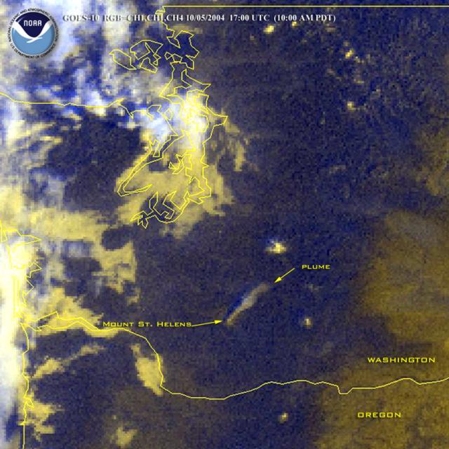 |
Figure 47. Image of St. Helens on 5 October 2004 from a Geostationery Operational Environmental Satellite (GOES-10) showing a consistent ash-bearing plume extending NE for ~ 40 km. Courtesy of NOAA. |
Figure 48 presents four aerial views into the crater, taken on 8 August and 7, 10, and 14 October. They portray the southern part of the crater containing a broad area of uplift and deformation associated with a more restricted zone of dome emergence. On 7 October the broad area of uplift on the S side of the 1980-86 lava dome stood ~ 400 m (N-S) by ~500 m (E-W), with a maximum uplift of about 100-120 m. For perspective on this growth, CVO's 11 November estimate noted an expanded area of uplift and some parts of the dome rising ~250 m above the glacier.
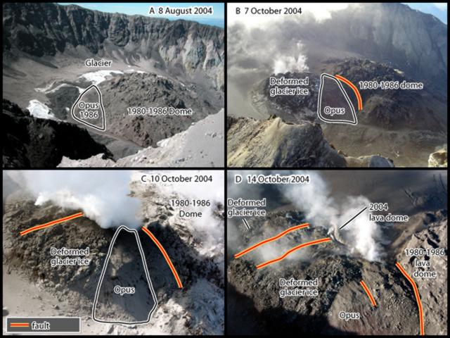 |
Figure 48. Four aerial photos depicting the southern portion of St. Helens's crater, an area of rapid uplift and dome emergence, from the S on 8 August and 7 October, and from the E on 10 and 14 October. The photos include an older dome lobe that was recently uplifted (Opus), steam releases, faulting (with upwards displacement towards the center), and the emergence of fresh dome lavas. Courtesy of USGS Cascades Volcano Observatory. |
Table 5 summarizes CVO's observations. The terminology of numbered days for this eruption began at Day 1 (23 September), when precursory earthquakes began (BGVN 29:09). In contrast to those initial several weeks, during the current reporting interval seismicity generally remained low, an observation consistent with the slow rise of gas-poor magma. The emerging magma drove uplift of the glacier within the crater but did not yield large explosive discharges and tall plumes.
Table 5. A simplified chronology of the events at St. Helens from 23 September to 12 November 2004. Regarding the Hazard Status column, the colors in parentheses represent an informal aviation hazard status (low to high; green, yellow, orange, and red). Taken from material posted by the USGS.
| Day | Date | Hazard Status | Comment |
| DAY 17 | 09 Oct 2004 | 2 - Advisory (Orange) | Moderate seismic activity-earthquakes up to M 2 at one event every two or three minutes. |
| DAY 18 | 10 Oct 2004 | 2 - Advisory (Orange) | Earthquakes up to M 1 every minute. |
| DAY 19 | 11 Oct 2004 | 2 - Advisory (Orange) | Low seismicity. Thermal imaging of the uplifted area (last seen on the 7th) found it had grown. The W portion of the uplift was steaming over a large diffuse area. Maximum measured surface temperatures were 200-300°C. Uplifting area discharged a brief emission at about 1600. Dusting of ash on new snow disclosed minor ash emissions the previous night. |
| DAY 20 | 12 Oct 2004 | 2 - Advisory (Orange) | Low seismicity (earthquakes up to M 1 every 5-10 minutes). Thermal imaging of the W part of the uplifting area revealed temperatures of 500-600°C on a large pinkish-gray fin of rock and in nearby fumaroles and cracks. |
| DAY 21 | 13 Oct 2004 | 2 - Advisory (Orange) | Hot (600°C) area both confirmed and appeared to have increased in size. Low seismicity; abundant steaming; SO2 and H2S detected; CO2 undetected; temperature and flow rate of water in streams similar to that measured in September. |
| DAY 22 | 14 Oct 2004 | 2 - Advisory (Orange) | A zone approaching 700°C and in places reaching 761°C was measured on the new lobe, which emitted ash-rich jets rising ten's of meters. Abundant steam continued to rise from the area of lava extrusion to the crater rim. Low seismicity. |
| DAY 23-40 | 15-31 Oct 2004 | 2 - Advisory (Orange) | Slight increase noted in area of uplift and new lobe of lava. On the 22nd a new protrusion of lava registered ~ 650°C. Slight increase in seismicity on 17th, but storm noise as well as rainfall triggering a small debris flow had also occurred; otherwise, seismicity was low. |
| DAY 41-53 | 01-12 Nov 2004 | 2 - Advisory (Orange) | On the 5th there was an ash plume to ~ 3 km altitude; on the 9th, a steam plume rose to similar altitude. Also, a new extrusion was noted on the 5th (see text). By the 11th the dome's highest point stood ~ 250 m above the height of the glacier's surface prior to the eruption. On the 11th the hottest lava registered ~700°C. Low seismicity generally prevailed. |
Thermal images of the exposed dome revealed elevated temperatures there. This confirmed that new lava had reached the surface of the uplift.
Other details. The weather enabled clear views on 10 October. A photo of the scene at dawn showed an orange-colored plume. Field observers noted fresh snow over the crater floor contained a thin SE-directed ash deposit stretching to just beyond the crater rim. A steam plume rose to crater rim level or slightly above all day on 10 October and continued to blow SE. USGS field workers described the plume as "lazy," emphasing the absence of gas thrusts or notably vigorous convection. When the field crew visited the volcano, the plume appeared clean, with no noticeable ash nor blue nor orange haze. The odor of H2S was noted at the crater's breach, but not elsewhere.
On 14 October observers noted an increase in the deforming and uplifting area on the S side of the 1980-1986 lava dome and the new lobe of lava in the W part of that area. The maximum temperature of 761°C was measured in parts of the new lobe from which ash rich jets rose ten's of meters. Magma extruded onto the surface, forming a new lobe of the lava dome. Instruments detected low levels of H2S and SO2, but no CO2.
Crews collected samples and documented clear dome growth on 20-21 October. The new lava extrusion had horizontal dimensions of ~ 300 x 75 m and a thickness of ~ 70 m. The fin-shaped lava spine had collapsed. The 21 October volume estimate was almost 2 x 10⁶ m3. By 21 October the area of uplift and intense deformation had advanced S, nearing the crater wall. That day, ~ 30 cm of new snow with a light dusting of ash covered much of the uplift, except for the new lava extrusion, which steamed heavily. A vigorous steam plume rose to 3 km. Fluxes of gaseous H2S, SO2, and CO2 were low. Samples of the new dome were scooped up by a container slung on a line beneath a helicopter.
Atmospheric conditions on 27 October and 7 November again gave airborne observers clear views into the crater (figures 49, 50, and 51). The N-looking photo in figure 12 documents how the new dome and area of uplift had achieved substantial size, standing topographically above what was previously the moat to the S of the older dome. In plan view, the margin of the dome complex shifted from a circle to a figure-eight.
 |
Figure 49. An aerial photo looking downward and N-ward into the crater of Mt. St. Helens on 27 October 2004. The old (1980-86) dome is in the background and the new one, steaming, is in the foreground. Note uplifted, fractured ice around the margins of the 2004 intrusion. Some areas of ice and snow have gray color indicative of ashfall. The ridge along the inner crater wall intersects the rim at the approximate point where Ivan Savov stood when taking the photo presented in BGVN 29:09. Courtesy of CVO. |
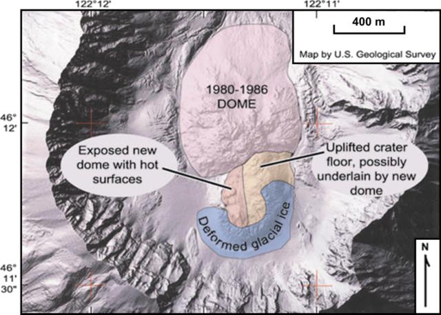 |
Figure 50. A simplified map of the St. Helens crater, based on the scene on 27 October 2004. More complex maps appeared in early November. Courtesy of CVO. |
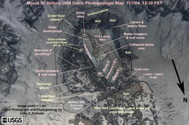 |
Figure 51. A photogeologic map depicting the southern end of the crater at St. Helens on 7 November 2004 and serving to identify and interpret recent deposits and features there. The map is centered on the new dome (N towards bottom, see arrow; for approximate scale, photo is ~ 1 km wide). The 1980-86 dome lies largely off the bottom of the photo. Courtesy of CVO. |
In addition to photos documenting crater changes, a CVO report on 29 October discussed rapid movement at a new GPS station on the southern part of the new dome (an area of uplifted glacial ice, rock debris, and new lava). The station showed continued southward motion of ~6 m in the previous 36 hours. A station near the summit of the old dome showed continued, slow northward motion.
Analysis of aerial photographs taken on 4 November led to an estimate of the volume of the uplifted area and new lava dome at ~ 20 x 106 m3. This followed other preliminary estimates made for 4 and 13 October of ~5 x 10⁶ m3 and ~12 x 106 m3, respectively. This most recent volume estimate (20 x 106 m3) amounted to more than 25% of the 1980-86 lava dome volume.
On 5 November the SO2 emission rates remained low. No H2S was detected and CO2 emission rates were not measurable. On that day viewers noted that a new mass of dacite had extruded, forming a spine rising ~100 m. Exposed rock faces had temperatures of 400-500°C. The steep new faces on the dome generated small hot rockfalls and avalanches. The finer particulate material rose to about 3 km altitude, a height ~900 m above the crater rim.
A sample of the new dome collected on 4 November established that the new dacite lava contained visible crystals of plagioclase, hornblende, and hypersthene. A comparison of the 1986 and 2004 dacites (table 6) shows that the new lava lacks augite, distinctive reaction rims on hornblende, and large plagioclase with sieve-textured cores.
Table 6. A comparison of the dome dacites extruded at St. Helens in 1986 and 2004. Courtesy of CVO.
| Year | Rock type | Mineralogy description |
| 1986 | Augite-hornblende-hypersthene dacite | 63.5 weight percent SiO2. Hypersthene is the dominant mafic mineral. Hornblende contains distinctive reaction rims. Accessory augite. Large plagioclase phenocrysts, commonly with sieve-textured cores. |
| 2004 | Hypersthene-hornblende dacite (collected 4 November) | 65.3 weight percent SiO2. Hornblende is the dominant mafic mineral, but it lacks significant reaction rims. Hypersthene is smaller and less abundant. Augite absent. Plagioclase phenocrysts, but absent large ones with sieve-textured cores. |
On 11 November the dome had reached ~ 250 m in height; it lay within a broad area of deformation that was ~ 600 m in diameter. Within this area, the new lava dome continued to occupy the E-central segment (broadly similar to the situation on figures 13 and 14). In plan view, the new dome stood 400 x 180 m. Regarding its height, the 11 November report noted that the highest point on the new lava dome was ~ 250 m "above the former surface of the glacier that occupied that point in mid-September."
Aviation Advisories. The first sentence of this section in BGVN 29:09 should be corrected to read, "The Washington VAAC issued advisories beginning on 29 September" (not 29 October).
The Washington Volcanic Ash Advisory Center issued one Ash Advisory each day during 9-18 October, noting elevated seismicity but a lack of explosive eruptions and substantial plumes. On 18 October the VAAC mentioned GOES-10 and -12 infrared and multispectral imagery of the volcano but concluded that "...after discussion with authorities at [CVO] we are discontinuing the Watch.... There continues to be low level [activity] ... not posing an [imminent] threat to aviation. A Notice to Aviation within ~9 km and below FL 130 should continue [Note: FL130, Flight Level 130, is the aviation community's shorthand for 13,000 feet; an altitude equivalent to 3,962 m, but typically rounded in the Bulletin to the nearest hundred meters]. If threat conditions rise[,] a Watch will again be issued. The Washington VAAC will continue to monitor the area and if ash is observed or reported a Volcanic Ash Advisory will be issued as soon as possible."
As of 12 November, the last Ash Advisory on St. Helens was issued on 6 November. It was in response to a minor ash emission that day. The emission was too small to detect with available satellite imagery. The local webcamera showed a weak, passively rising plume that barely rose above the crater rim.
Geological Summary. Prior to 1980, Mount St. Helens was a conical volcano sometimes known as the Fujisan of America. During the 1980 eruption the upper 400 m of the summit was removed by slope failure, leaving a 2 x 3.5 km breached crater now partially filled by a lava dome. There have been nine major eruptive periods beginning about 40-50,000 years ago, and it has been the most active volcano in the Cascade Range during the Holocene. Prior to 2,200 years ago, tephra, lava domes, and pyroclastic flows were erupted, forming the older edifice, but few lava flows extended beyond the base of the volcano. The modern edifice consists of basaltic as well as andesitic and dacitic products from summit and flank vents. Eruptions in the 19th century originated from the Goat Rocks area on the N flank, and were witnessed by early settlers.
Information Contacts: Cascades Volcano Observatory (USGS/CVO), U.S. Geological Survey, 1300 SE Cardinal Court, Building 10, Suite 100, Vancouver, WA 98683-9589, USA (URL: https://volcanoes.usgs.gov/observatories/cvo/); Pacific Northwest Seismograph Network (PNSN), Seismology Lab, University of Washington, Department of Earth and Space Sciences, Box 351310, Seattle, WA 98195-1310, USA (URL: http://www.pnsn.org/); Washington Volcanic Ash Advisory Center (VAAC), Satellite Analysis Branch (SAB), NOAA/NESDIS E/SP23, NOAA Science Center Room 401, 5200 Auth Road, Camp Springs, MD 20746, USA (URL: http://www.ospo.noaa.gov/Products/atmosphere/vaac/); R. Scott Ireland, 1660 NW 101 Way, Plantation, FL 33322, USA (URL: http://rsiphotos.com/); Stephen and Donna O'Meara, Volcano Watch International, PO Box 218, Volcano, HI 96785, USA.