Report on Montagu Island (United Kingdom) — October 2004
Bulletin of the Global Volcanism Network, vol. 29, no. 10 (October 2004)
Managing Editor: Richard Wunderman.
Montagu Island (United Kingdom) Higher-resolution image shows abundant ash, not lava, on the N-flank
Please cite this report as:
Global Volcanism Program, 2004. Report on Montagu Island (United Kingdom) (Wunderman, R., ed.). Bulletin of the Global Volcanism Network, 29:10. Smithsonian Institution. https://doi.org/10.5479/si.GVP.BGVN200410-390081
Montagu Island
United Kingdom
58.445°S, 26.374°W; summit elev. 1370 m
All times are local (unless otherwise noted)
Matt Patrick of the Hawaii Institute of Geophysics and Planetology reviewed our previous report on Montagu Island (BGVN 29:09) and noted some erroneous interpretations. These had relied on imagery from 1 October 2004. Patrick generated a significantly improved, scaled, higher (4-m) resolution IKONOS image from the same time frame (figure 8), and offered some refinements and important corrections.
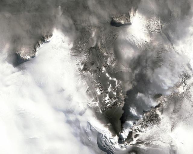 |
Figure 8. A 1 October 2004 image of Montagu Island taken with the IKONOS satellite (N towards the top; distance from summit vent to N coast is ~3 km). A lower higher resolution image appeared in BGVN 29:09. This new image indicates that tephra—not lava flows as previously reported—covers much of the ice over a sector on the island's N side. Courtesy of Space Imaging, NASA, and Matt Patrick. |
First, the previous report noted that "the area of apparently continuous flows seems to have reached the island's N margin (a distance of 3 km)." Over the entire new image there doesn't seem to be any new vents nor lava. The darkened area N of the Belinda summit cone contains clear crevasses indicating a region of ice entirely covered in ash.
A second erroneous statement was, "Another visible feature, the black area to the NNW . . . presumably reveals lava flows emerging from beneath the ice." Patrick points out that on the new image this area is seen to contain some of the island's rocky cliffs contrasting against the ice cover. He attributed the darkness around this area mainly to shadow. The presence of rocky cliffs negates another statement in the previous issue: "The black area to the NNW may thus be a new vent area."
The previous report commented that, "Another such [dark, presumably lava-covered] area may reside on the NNE flanks, midway from the summit area and the coast." Patrick noted that on the new image this area appears chaotic and can easily be misidentified as recent volcanics. He goes on to say, "We made a similar mistake earlier on, thinking there were concentric fractures related to subglacial melting. But it turned out from pre-eruption images that this area is just covered in topographic crevasses. Looking at the [improved] IKONOS image, one can see this more clearly."
Patrick offered interpretations of some features on the new image, the first high-resolution image since February 2004. It shows continued steaming from Mount Belinda as well as tephra cover on the surrounding ice field, activity very similar to that seen on all the previous imagery. Although the new IKONOS image lacks any evidence of new lava since the 2003 lava flow, that particular lava field lies hidden under the steam plume in the IKONOS image. Thus, there could be newer material in that small region. The IKONOS image appears devoid of new vents, and emissions come solely from the summit area.
Geological Summary. The largest of the South Sandwich Islands, Montagu consists of a massive shield volcano cut by a 6-km-wide ice-filled summit caldera. The summit of the 11 x 15 km island rises about 3,000 m from the sea floor between Bristol and Saunders Islands. Around 90% of the island is ice-covered; glaciers extending to the sea typically form vertical ice cliffs. The name Mount Belinda has been applied both to the high point at the southern end of the summit caldera and to the young central cone. Mount Oceanite, an isolated peak at the SE tip of the island, was the source of lava flows exposed at Mathias Point and Allen Point. There was no record of Holocene activity until MODIS satellite data, beginning in late 2001, revealed thermal anomalies consistent with lava lake activity. Apparent plumes and single anomalous pixels were observed intermittently on AVHRR images from March 1995 to February 1998, possibly indicating earlier volcanic activity.
Information Contacts: Matt Patrick, HIGP Thermal Alerts Team, Hawai'i Institute of Geophysics and Planetology (HIGP) / School of Ocean and Earth Science and Technology (SOEST), University of Hawai'i, 2525 Correa Road, Honolulu, HI 96822, USA (URL: http://modis.higp.hawaii.edu/).