Report on False Reports (Unknown) — November 2004

Bulletin of the Global Volcanism Network, vol. 29, no. 11 (November 2004)
Managing Editor: Richard Wunderman.
False Reports (Unknown) Andaman Islands: False reports of eruptions and confusion following the M 9 earthquake
Please cite this report as:
Global Volcanism Program, 2004. Report on False Reports (Unknown) (Wunderman, R., ed.). Bulletin of the Global Volcanism Network, 29:11. Smithsonian Institution. https://doi.org/10.5479/si.GVP.BGVN200411-600600
False Reports
Unknown
Lat Unknown, Unknown; summit elev. m
All times are local (unless otherwise noted)
False reports of volcanism surfaced describing eruptions at Barren Island and Narcondum volcanoes (figure 1) following the 26 December 2004, M 9 earthquake off the W coast of northern Sumatra. Clarification was provided by Dornadula Chandrasekharam of the Indian Institute of Technology. He reported an absence of volcanic activity at these volcanoes, and at Sumatran volcanoes, as recently as 4 January 2005.
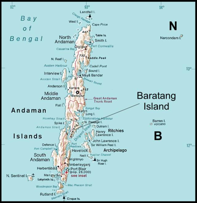 |
Figure 1. A map of the Andaman Islands showing the only volcanoes known to have erupted during the Holocene period (past 10,000 years), Narcondum and Barren Island (N and B, respectively). Note that narrow straits break Andaman island into multiple smaller islands (eg., Middle Andaman and Baratang islands). Baratang Island contains an established, studied, active mud volcano that reactivated after the M 9 earthquake. |
The erroneous accounts were discovered by Chandrasekharam while watching television news. He immediately contacted people in the Andaman region. Upon learning that these reports were incorrect, he contacted media sources and the Global Volcanism Network. Many Indian news sources that proclaimed eruptions at Barren Island later withdrew their reports. The erroneous information prevailed for a day to perhaps a week, although non-Indian news agencies were slower to recognize and acknowledge the error.
Regional tectonic setting. Figure 2 illustrates the rudiments of the regional tectonic setting, including the primary M 9 earthquake and aftershocks for the next 10 days. The tectonic reconstructions are far more complex than shown here, and the details are variously interpreted.
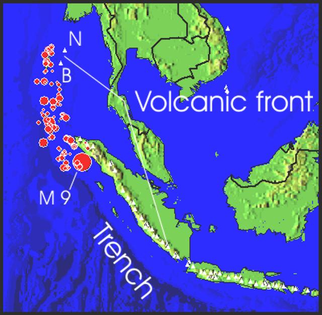 |
Figure 2. Map showing the broad tectonic setting on which Barren Island and Narcondam volcanoes reside. The map began with the main shock of the M 9 earthquake and the earthquakes that followed during the next 11 days. USGS preliminary tabulations computed the main shock as Mw 9.0 with a focus at 30 km depth. |
In terms of local time (in the Andaman Islands and India, i.e. India Standard Time), the epicenters shown occurred during the time interval 06:28:53 on 26 December to about 06:57 on 6 January. (In terms of UTC, this represents the interval 00:58:53 on 25 December to about 19:57 on 5 January 2004). This digital map was extracted by applying a video simulation of epicenters with time (Jones and others, 2002) to the recent seismic data.
The figure shows two prominent curving tectonic features crossing both Java-Sumatra and the Andaman Sea (the Nicobar and Andaman Islands region). One such curving feature is the volcanic front, on which lie all the active volcanoes of Java and Sumatra, and farther N, Barren Island and Narcondam. Outboard of that (to the W) is the second curving feature, the Sunda trench and islands adjacent to it (the Andaman Islands, and islands to the W of northern Sumatra hard-hit by the M 9 earthquake and tsunami). The trench reflects the sea-floor expression of the subduction zone, and represents the region where the M 9 earthquake occurred. The offset, often termed a 'megathrust,' involved 1,200 km of rupture along the subduction zone, and suddenly shifted the Indian Ocean's floor ~15 m towards Sumatra (Hopkin, 2005).
Regarding the M 9 earthquake, according to the USGS, the local time and date in terms of local time in N Sumatra at the epicenter was Sunday, 26 December 2004 at 07:58:53 (i.e., roughly 8 am). The USGS provided a table showing the time of the main shock in a variety of time zones.
Some excellent tutorials have provided background on the tectonic setting, the earthquake, and the tsunami. These have appeared in the press and on the web (eg. Sieh, 2004, 2005; NOAA, http://www.noaa.gov/tsunamis.html). Although large earthquakes may trigger volcanism (Linde and Sacks, 1998), so far this does not appear to be the case, at least at the volcanoes of Barren Island and Narcondum.
Mud volcanoes and ensuing confusion. Post-earthquake reports of active 'mud volcanoes' in the Andaman Islands caused panic and confusion in the region, and came at a particularly bad time. Chandrasekharam pointed out that in Andaman, like many other arc provinces, several mud volcanoes are present. These are not real volcanoes in the usual sense, but because they may build a small, low-profile cone of local extent around the hole through which the mud is thrown out, they are known as mud volcanoes (figure 3).
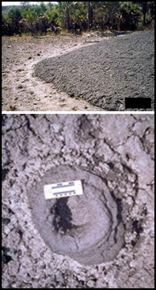 |
Figure 3. A 2003 photograph showing about a quarter to one half of a mud volcano on Baratang island (top) and its largest crater (~20 cm in diameter, ~ 28 cm in depth) (bottom). This site was known as a minor fissure prior to 1983; but in that year the largest outburst occurred, chiefly emitting warm (~ 30°C) mud. Mud again began emerging in February 2003. The dominant feature was a sub-circular mound of mud, ~30 m in diameter with a height of ~2 m at the center. Observers noted a colorless, sulfurous smelling gas. The mud contained angular to sub-rounded rock fragments from underlying strata. No photos nor similarly detailed technical reports have been received showing alleged recent activity that began 27 December 2004 (see text for news report). All photos and data courtesy of the Geological Survey of India, Eastern Region. |
Some of the difficulty with the news reports was that the mud volcanoes' locations, numbers, and impacts remained vague, and that Barren Island became intertwined with story. An extreme example came from an irresponsible report in the tabloid India Daily(2 January 2005), which contained the title "Volcano[es] Barren-1 and Narcondam erupt in Andaman—Seismic disturbance can cause more tsunami." It continued with wild claims such as, "Severe seismic activities are seen in these islands... personnel who have reached these remote areas are facing shattering earth vibrations and high waves," and "Some scientists are predicting severe earthquake again in the North of Andaman Nicobar Islands. The effect can be severe on Myanmar, Andaman, Indi[a]'s east coast, Bangladesh and Sumatra...." They added, "Andaman's tribals strangely are unaffected as most of them somehow went [to] higher ground before the tsunami. So did the animals." Science journalism clearly has a lot to compete with (see Oldenburg, 2005, for more discussion of these topics).
One alleged mud volcano 'Barren-1' has a name so close to the volcano's name (Barren Island) that it was frequently confused. The mud volcano's name (if there is one) appears to be absent from the technical literature at the Geological Survey of India's website.
On a positive note, one mud volcano received consistent mention in a number of news articles and provided coverage generally congruent with geological data posted by the Geological Survey of India. According to an article in India News(with the leader, "Port Blair, 30 December"), "A mud volcano at the inhabited Baratang Island in Middle Andaman has erupted but the administration said there was no cause for concern. 'Mud keeps bubbling in the volcano, but on December 28, the eruption was up to three meters and there was considerable heat,' Inspector General of Police S. B. Deol said here."
"He [also] said the mud volcano was located on one side of the Baratang Island, which was about 100 km from Port Blair. People live on the other side, but there is no cause for concern."
A report in the India Dailywas nearly identical. Details on a Geological Survey of India website noted that the Baratang mud volcano began erupting on 27 December 2003 (figure 3 and caption). Mud volcanoes may have also occurred elsewhere in the region, but the available news reports consistently failed to disclose locations.
Often associated with active faults and with petroleum fields, mud volcanoes on land consist of low-lying surface mud extrusions that vary in size from meters to several kilometers across. They emit mud at temperatures significantly below magmatic, which are typically at least 800°C. Eruptions from mud volcanoes can reach heights of several hundred meters and consist of mud, fluids and gases, and sometimes burning hydrocarbons. Although in submarine environments mud volcanoes can be extensive, deadly mud volcano eruptions are extremely rare because their eruptions seldom move far enough to affect large areas of the land surface. Their greatest danger may be to curious onlookers who venture too close.
References.Jones, A., Siebert, L., Kimberly, P., and Luhr, J.F., 2002, Earthquakes and Eruptions, v. 2.0 (CD-ROM): Smithsonian Institution, Global Volcanism Program, Digital Information Series, GVP-2.
Hopkin, M., 2005, Triple slip of tectonic plates caused seafloor surge: Nature, v. 433, no. 3 (06 Jan 2005).
Linde, A.T., and Sacks, I.S., 1998, Triggering of volcanic eruptions: Nature, v. 395, p. 888-890.
Oldenburg, D., 2005, A sense of doom: Animal instinct for disaster—Scientists investigate wildlife's possible warning systems: The Washington Post (8 January 2005), p. C1, C3 (URL: http://www.washingtonpost.com/).
Sieh, K., 2004, The science behind the Aceh earthquake: Caltech Media Relations (30 December 2004), (URL: http://pr.caltech.edu/media/Press_Releases/PR12628.html).
Sieh, K., 2005, In Sumatra: Notes From a Geologist in the Field: Caltech Today (1 January 2005, URL: http://today.caltech.edu/today/).
U.S. National Earthquake Information Center (NEIC) (URL: https://earthquake.usgs.gov)./
U.S. National Oceanic and Atmospheric Administration (NOAA) (URL: http://www.noaa.gov/tsunamis.html).
Geological Summary. False or otherwise incorrect reports of volcanic activity.
Information Contacts: Dornadula Chandrasekharam, Department of Earth Sciences, Indian Institute of Technology, Bombay 400076, India; India News (URL: http://news.newkerala.com/india-news/); India Daily (URL: http://www.indiadaily.com/); The Washington Post, Washington DC, USA (URL: https://www.washingtonpost.com/); Geological Survey of India, 27 Jawaharlal Nehru road, Kolkata (Calcutta) 700016, India.