Report on Raung (Indonesia) — January 2005

Bulletin of the Global Volcanism Network, vol. 30, no. 1 (January 2005)
Managing Editor: Richard Wunderman.
Raung (Indonesia) MODIS-MODVOLC infrared hot spots 3 June-8 Oct 2004; aerial photos from 2001
Please cite this report as:
Global Volcanism Program, 2005. Report on Raung (Indonesia) (Wunderman, R., ed.). Bulletin of the Global Volcanism Network, 30:1. Smithsonian Institution. https://doi.org/10.5479/si.GVP.BGVN200501-263340
Raung
Indonesia
8.119°S, 114.056°E; summit elev. 3260 m
All times are local (unless otherwise noted)
Though frequently active, Raung is seldom the subject of reports from either the news media or the Directorate of Volcanology and Geological Hazard Mitigation (DVGHM). The most recent Darwin VAAC report was issued late on 26 August 2002 (UTC). It noted that aviators had estimated an ash plume at ~ 10 km altitude drifting W (reported 25 August in an AIREP). Ash clouds were not visible on NOAA/GMS satellite imagery. A summary of Darwin VAAC reports of Raung for the period July 1999-August 2002 was given in BGVN 29:01.
There were nine anomalous Moderate Resolution Imaging Spectroradiometer (MODIS) observations of volcanic hot spots at Raung during 3 June-8 October 2004 (table 2). The 2004 alerts were the first detected by MODIS at Raung. Minor explosive activity documented intermittently during 1999 to 2002 (BGVN 29:01) did not have a thermal component sufficient to trigger alerts.
Table 2. Thermal anomalies at Raung observed with MODIS during 2004. Some of the UTC times were for the previous date. Spectral radiance for the hot pixels in band 21 (central wavelength of 3.959 µm) are in units of watts per square meter per steradian per micron (W-2 sr-1 µm-1). Courtesy of the Hawaiian Institute of Geophysics and Planetology.
| Date | Local Time | UTC | Spectral Radiance |
| 15 Apr 2004 | 2300 | 1500 | 0.852 |
| 16 Apr 2004 | 0200 | 1800 (15 Apr) | 0.847 |
| 22 Apr 2004 | 2310 | 1510 | 0.814 |
| 02 May 2004 | 0200 | 1800 (01 May) | 0.813 |
| 03 Jun 2004 | 0200 | 1800 (02 Jun) | 0.677 |
| 18 Jun 2004 | 2300 | 1500 | 0.729 |
| 04 Jul 2004 | 2300 | 1500 | 0.795 |
| 11 Jul 2004 | 2310 | 1510 | 0.814 |
| 14 Jul 2004 | 0155 | 1755 (13 Jul) | 0.778 |
| 22 Sep 2004 | 2300 | 1500 | 0.849 |
| 23 Sep 2004 | 0200 | 1800 (22 Sep) | 0.740 |
| 29 Sep 2004 | 2305 | 1505 | 0.893 |
| 08 Oct 2004 | 2300 | 1500 | 0.776 |
No ground observations have been reported during 2004, but in a message from Dali Ahmad (DVGHM), he noted the absence of observed emissions during 2004. With respect to the thermal alerts, he speculated that they could conceivably have originated from brush fires. Rob Wright commented that the levels of radiance in the 2004 alerts were both "too weak and too intermittent to be lava flows" and stood near the system's lower threshold. Similar weak anomalies occur at volcanoes such as Villarrica and during intervals at Anatahan, but the source of the alerts at Raung remains uncertain.
Clear aerial photographs of Raung were taken on 26 and 30 July 2001 (figure 2) by Franz Jeker of Singapore Airlines as he flew past in descent towards, or ascent from, the Bali airport. Jeker also included a detailed map of the Raung area (figure 3).
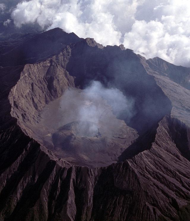 |
Figure 2. A photograph taken on 26 July 2001 of a small fumarolic plume from the central crater of Raung looking SW during a fly-by of a commercial airplane across the NNE flank. Courtesy of F. Jeker. |
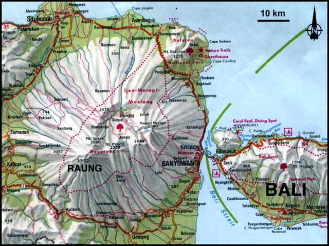 |
Figure 3. Map showing relative locations of Raung volcano at the SW end of Java, and adjacent Bali. Courtesy of F. Jeker. |
Geological Summary. Raung, one of Java's most active volcanoes, is a massive stratovolcano in easternmost Java that was constructed SW of the rim of Ijen caldera. The unvegetated summit is truncated by a dramatic steep-walled, 2-km-wide caldera that has been the site of frequent historical eruptions. A prehistoric collapse of Gunung Gadung on the W flank produced a large debris avalanche that traveled 79 km, reaching nearly to the Indian Ocean. Raung contains several centers constructed along a NE-SW line, with Gunung Suket and Gunung Gadung stratovolcanoes being located to the NE and W, respectively.
Information Contacts: Directorate of Volcanology and Geological Hazard Mitigation (DVGHM), Jalan Diponegoro 57, Bandung 40122, Indonesia (URL: http://www.vsi.esdm.go.id/); Darwin Volcanic Ash Advisory Center (VAAC), Bureau of Meteorology, Northern Territory Regional Office, PO Box 40050, Casuarina, NT 0811, Australia (URL: http://www.bom.gov.au/info/vaac/); Hawai'i Institute of Geophysics and Planetology (URL: http://modis.higp.hawaii.edu); Franz Jeker, Rigistrasse 10, 8173 Neerach, Switzerland.