Report on Soufriere Hills (United Kingdom) — March 2005

Bulletin of the Global Volcanism Network, vol. 30, no. 3 (March 2005)
Managing Editor: Richard Wunderman.
Soufriere Hills (United Kingdom) Comparative quiet during 26 November 2004 to 4 March 2005
Please cite this report as:
Global Volcanism Program, 2005. Report on Soufriere Hills (United Kingdom) (Wunderman, R., ed.). Bulletin of the Global Volcanism Network, 30:3. Smithsonian Institution. https://doi.org/10.5479/si.GVP.BGVN200503-360050
Soufriere Hills
United Kingdom
16.72°N, 62.18°W; summit elev. 915 m
All times are local (unless otherwise noted)
This report covers the period 26 November 2004 to 4 March 2005. Soufrière Hills volcano remained quiet after late November, with seismic signals, gas emissions, and rockfalls all decreasing (table 59 and BGVN 29:10).
Table 59. Geophysical and geochemical data recorded at Soufrière Hills, 26 November 2004 to 4 March 2005. Wind directions or trouble with gas-monitoring equipment prevented measurement of SO2 fluxes on some days. Courtesy of MVO.
| Date | Seismicity Level | Hybrid EQ's | Mixed EQ's | Volcano-tectonic EQ's | Long-period EQ's | SO2 flux (tons/day) | Rockfalls |
| 26 Nov-03 Dec 2004 | -- | 9 | -- | 7 | -- | 130-590 | 4 |
| 03 Dec-10 Dec 2004 | -- | 7 | -- | -- | -- | 250-370 | 1 |
| 10 Dec-17 Dec 2004 | -- | 6 | -- | 7 | -- | 290-450 | -- |
| 17 Dec-24 Dec 2004 | -- | 6 | -- | 1 | -- | 200-500 | -- |
| 24 Dec-31 Dec 2004 | -- | 6 | -- | 2 | 1 | 300-550 | -- |
| 31 Dec-07 Jan 2005 | -- | 4 | -- | -- | -- | 310-400 | -- |
| 07 Jan-14 Jan 2005 | -- | 5 | -- | 5 | -- | 180-511 | -- |
| 14 Jan-21 Jan 2005 | -- | 2 | -- | -- | -- | 300-3801 | 2 |
| 21 Jan-28 Jan 2005 | -- | 5 | -- | -- | 1 | 350-6701 | -- |
| 28 Jan-04 Feb 2005 | -- | 2 | -- | 1 | 7 | 4101 | -- |
| 04 Feb-11 Feb 2005 | low | -- | -- | -- | -- | -- | -- |
| 11 Feb-18 Feb 2005 | low | -- | -- | -- | -- | -- | -- |
| 18 Feb-25 Feb 2005 | low | -- | -- | -- | -- | 280-9801 | -- |
| 25 Feb-04 Mar 2005 | low | 6 | -- | 3 | -- | 6721 | 2 |
While volcanic-tectonic and hybrid earthquakes (as many as 40/week) shook SHV from mid-October to late November, few were recorded between late November and early March (table 1). During the week of 25 February, winds shifted and carried the smell of sulfur to northern parts of the island. However, SO2 emissions remained low and stable throughout December, January, and February. The average for this reporting period was ~ 400 tons/day, which is below the long-term average of 500 tons/day.
Rain and mudflows have also subsided. A mudflow in the Belham Valley on 15 December was the only event recorded for this reporting period.
An exceptionally clear day enabled scientists to obtain unusually clear photos on 1 February 2005 (figures 58, 59, and 60). Flights were made during November, December, and January as well. During the November-February interval, scientists saw relatively few changes in the surface morphology. Chances Pond, the pool of brownish water sitting in the explosion pit formed on 3 March 2004, still remained. MVO scientists noted around 26 November 2004 that the pond had changed from brownish to milky.
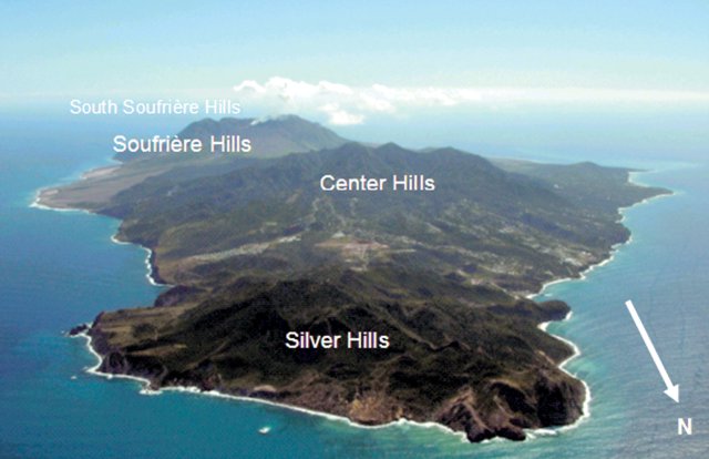 |
Figure 58. Montserrat from the NNE at an altitude of ~ 1,500 m, clearly showing the island's three main volcanic centers: the oldest and extinct Silver Hills (more than a million years old) in the foreground; the highest, densely foliated Centre Hills (also extinct, 0.5-1 million years old), and the steaming Soufrière Hills (220,000 years old), furthest away. Courtesy of MVO. |
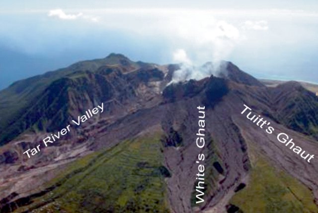 |
Figure 59. A photo of Soufrière Hills volcano taken from the NE showing the dome within the breached summit crater, and the SW-flank morphology. Much of the steam discharging was attributed to fumaroles. Photographed on 1 February 2005. Courtesy of MVO. |
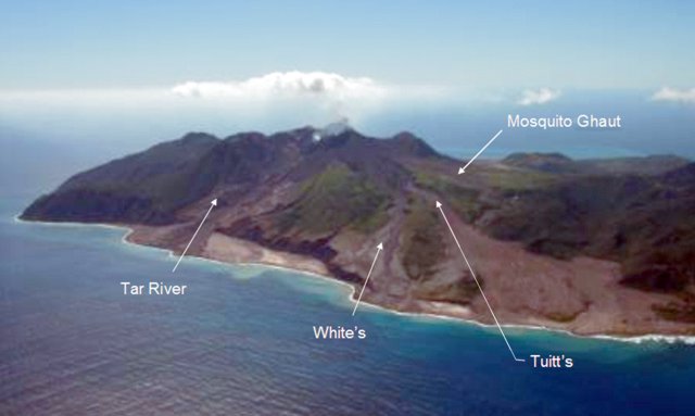 |
Figure 60. Recent deposits on the SW flank of Soufrière Hills as viewed from the NE on 1 February 2005. Prominent deltas appear at the mouths of the drainages shown, particularly at the mouth of the Tar River Valley. Courtesy of MVO. |
On 3 March 2005, scientists took a Fourier Transform Infrared spectrometer (FTIR) reading of the gas escaping from the crater vent at the summit (figure 59). The gas plume contained a ratio of hydrogen chloride to sulfur dioxide by mass of 0.35. This ratio showed no change since February.
In September 2004, the Scientific Advisory Committee on Montserrat Volcanic Activity (SAC) joined MVO staff at the Montserrat Volcano Observatory to discuss recent activity (SAC, 2004). "Few signs of surface activity" was their appraisal of the period since March 2004. There had been little gas venting, ash venting, or tremor in six months, and no lava extrusion in 15 months. This pause in activity, the SAC predicted, will last ~ 26 months, but could last as long as 170 months. SAC estimated risks for a variety of circumstances.
Readers can access full reports issued by the SAC at the MVO website. The main report summarizes conclusions drawn from the meeting, while the technical report includes long-term monitoring data and risk assessments.
Reference. Scientific Advisory Committee on Montserrat Volcanic Activity (SAC), 2004, Assessment of the hazards and risks associted with the Soufriere Hills volcano, Montserrat: Second Report of the Scientific Advisory Committee on Montserrat Volcanic Activity, parts I (Main Report, 24 p.) and II (Technical Report, 26 p.).
Geological Summary. The complex, dominantly andesitic Soufrière Hills volcano occupies the southern half of the island of Montserrat. The summit area consists primarily of a series of lava domes emplaced along an ESE-trending zone. The volcano is flanked by Pleistocene complexes to the north and south. English's Crater, a 1-km-wide crater breached widely to the east by edifice collapse, was formed about 2000 years ago as a result of the youngest of several collapse events producing submarine debris-avalanche deposits. Block-and-ash flow and surge deposits associated with dome growth predominate in flank deposits, including those from an eruption that likely preceded the 1632 CE settlement of the island, allowing cultivation on recently devegetated land to near the summit. Non-eruptive seismic swarms occurred at 30-year intervals in the 20th century, but no historical eruptions were recorded until 1995. Long-term small-to-moderate ash eruptions beginning in that year were later accompanied by lava-dome growth and pyroclastic flows that forced evacuation of the southern half of the island and ultimately destroyed the capital city of Plymouth, causing major social and economic disruption.
Information Contacts: Montserrat Volcano Observatory (MVO), Fleming, Montserrat, West Indies (URL: http://www.mvo.ms/).