Report on Ol Doinyo Lengai (Tanzania) — April 2005

Bulletin of the Global Volcanism Network, vol. 30, no. 4 (April 2005)
Managing Editor: Richard Wunderman.
Ol Doinyo Lengai (Tanzania) Tall hornito almost reaches summit elevation; more lava spills over rim
Please cite this report as:
Global Volcanism Program, 2005. Report on Ol Doinyo Lengai (Tanzania) (Wunderman, R., ed.). Bulletin of the Global Volcanism Network, 30:4. Smithsonian Institution. https://doi.org/10.5479/si.GVP.BGVN200504-222120
Ol Doinyo Lengai
Tanzania
2.764°S, 35.914°E; summit elev. 2962 m
All times are local (unless otherwise noted)
Although lava venting at Ol Doinyo Lengai continued intermittently after February 2004 (BGVN 29:02), no significant changes were detected until July 2004, a time when vigorous venting emitted substantial amounts of the low-viscosity carbonatitic lava typical at this volcano ('flash floods' of lava). This summary report covers the time interval from February 2004 through early February 2005 based on observations made by Frederick Belton, Celia Nyamweru, Bernhard Donth, and Christoph Weber. Websites devoted to Ol Doinyo Lengai, including photographs, information on the evolution, recent history, and current status of the volcano are maintained by Belton, Nyamweru, and Weber.
A map, thermal data, and some new elevation estimates. In February 2005 Weber and others collected location data with a global positioning system (GPS) receiver. Weber used this to create a sketch map of the active crater (figure 82).
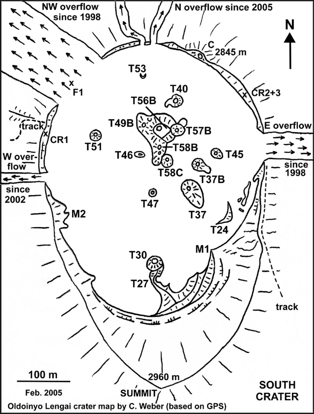 |
Figure 82. Sketch map of crater features at Ol Doinyo Lengai surveyed with a global positioning system (GPS) during 3-7 February 2005. During the course of the report interval, new vents developed at T49G and T58C (amid the N-central group of hornitos; T49G sits ~ 10 m E of T49B). These new vents produced comparatively vigorous eruptions. Courtesy of Chris Weber (Volcano Expeditions International, VEI). |
In July 2004 Belton completed the third of a series of distance measurements across crater outflow areas at the crater rim (table 7). Due to the unusually strong eruption on 15 July 2004 (figure 83), deposits comprising the E overflow widened by 3 or 4 m (growing from 44 to 47 m, figure 82). Later, in January 2005, observers noticed a fourth area of overflows had become established on the N crater rim, with lavas pouring over the rim at two adjacent points there (figure 82).
Table 7. For Ol Doinyo Lengai, the width of the three extant lava outflows at the points where they spilled from the active crater ('overflows,' figure 15), as measured during 2 August 2003-29 July 2004. Two additional small overflows formed later, by January 2005, on the N crater rim. The 3-m E-overflow increase occurred during the eruption of T58C on 15 July 2004. Courtesy of Frederick Belton.
| Date | NW overflow width | E overflow width | W overflow width |
| 02 Aug 2003 | 135 m | 44 m | 17 m |
| 29 Jun 2004 | 135 m | 44 m | 18 m |
| 29 Jul 2004 | 135 m | 47 m | 18 m |
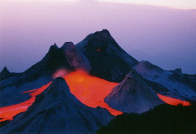 |
Figure 83. A time exposure photograph of Ol Doinyo Lengai taken just after sunset on 15 July 2004. At that time the newly formed vent T58C ("Charging Rhino") issued copious lava. This photo was taken looking approximately NW from the SE part of the crater rim. Courtesy of Frederick Belton. |
During 3-7 February 2005 Weber and others completed a series of lava and fumarole temperature measurements that appear as tables 8 and 9. The tables indicate the hottest lava and fumarole temperatures at cracks were 588°C (at T49C, February 2004) and 150°C (at T49G, June 2004), respectively. The hornitos T49C and T49G both lie near T49B, a hornito delineated on figure 82.
Table 8. Repeated maximum lava temperatures measured at Ol Doinyo Lengai during 28 August 1999 to 3 February 2005. The measurements were made employing a digital thermometer (TM 914C with a stab feeler of standard K type). The instrument was used in the 0-1200°C mode, and at least four replicate measurements were made at any one spot. Calibration was by the delta-T method; uncertainties were ± 6°C in the 0-750°C range. Courtesy of C. Weber.
| Date | Location | Temperature (°C) |
| 28 Aug 1999 | T40 lava lake | 529 |
| 01 Sep 1999 | Pahoehoe flow in a tube near T40 | 519 |
| 01 Sep 1999 | Aa flow still in motion at flat terrains (60 cm thick) | 516 |
| 03 Oct 2000 | Pahoehoe flow in a tube near T49B | 507 |
| 03 Oct 2000 | Aa flow still in slow motion at flat terrain (25 cm thick) | 496 |
| 11 Feb 2004 | Pahoehoe flow in a tube near T49G | 588 |
| 12 Feb 2004 | Pahoehoe flow in a tube near T49B | 579 |
| 13 Feb 2004 | Aa flow not in motion anymore at flat terrain (15 cm thick) | 490 |
| 26 Jun 2004 | Pahoehoe flow in slow motion (10 cm thick) flat terrain | 560 |
| 03 Feb 2005 | Pahoehoe flow (15 cm thick) in motion traveling within a levee. | 561 |
| 03 Feb 2005 | Aa flow not in motion anymore at flat terrain (15 cm thick) | 520 |
Table 9. Maximum fumarole temperatures measured at cracks in Ol Doinyo Lengai's crater floor over a series of visits during 28 August 1999 to 4 February 2005. Collected using the digital thermometer with procedures and parameters noted with the previous table. For locations, see map (figure 15). Courtesy of C. Weber.
| Date | Location | Temperature (°C) |
| 28 Aug 1999 | F1 | 70 |
| 28 Aug 1999 | Near T49 | 82 |
| 03 Oct 2000 | Near T49C | 75 |
| 03 Oct 2000 | F1 | 69 |
| 20 Oct 2002 | The hottest cracks in the crater floor | 124 |
| 20 Oct 2002 | F1 | 78 |
| 30 Jun 2003 | F1 | 86 |
| 30 Jun 2003 | Near T49C | 76 |
| 12 Feb 2004 | F1 | 88 |
| 26 Jun 2004 | F1 | 78 |
| 26 Jun 2004 | Near T49C | 150 |
| 04 Feb 2005 | F1 | 84 |
Weber's team GPS measurements suggested a summit elevation of 2,960 ± 5 m. This is consistent with GPS measurements taken in October 2000, by a scientific group led by Joerg Keller, of 2,950-2,960 m (BGVN 25:12). In addition, the tallest hornito in the N-central crater rises to nearly this elevation (see discussion of T49/T56B, below).
During observations in February 2004, Weber measured the tallest hornito at the T49 location (part of T56B) in the center area of the active crater. GPS readings on top of T56B yielded an elevation of 2,886 m. This is only [74 m below the elevation of the summit]. The top of T49 is also ~ 33 m above the adjacent crater floor to the N. In addition, when he measured on 3-7 February, Weber found hornito T58C (a then recent feature) had grown to reach an elevation of ~ 2,870 m.
Observations during February 2004 to February 2005. During February 2004 visits, T56B did not erupt, but instead a new vent erupted at the T49 location (~ 10 m E of T49B, see also BGVN 29:02). This new vent was called T49G (figure 15).
A group from Volcano Expeditions International (VEI) spent 24-30 June 2004 on Lengai and found much of the scene at the vents in the crater similar to that noted in February 2004. They noted that half of the upper 10 m of hornito T56B had collapsed on its E side, and an active lava lake had formed inside this hornito with lava escaping several times through the collapsed opening to its E and flowing out ~ 200 m. The lava was rich in gas with a temperature of 560°C. The hornito T58B was also active and spattered lava many times during these days of observation. Some lava flows from T58B reached about 150 m to the S.
During 2-3 July 2004, Belton observed T58B erupt repeatedly, emitting lava and strombolian displays. The escaping lava flowed S, passing near the base of hornito T47. On 4 July, Belton saw some of the most intense activity of the month. A sequence of lavas erupted on that day and over the next few days. However, events in mid-July and later were also unusually vigorous.
The 4 July 2004 activity included strong strombolian eruptions at T58B and several collapses of its vent area, which released large cascades of lava onto the crater floor. Simultaneously, a tube-fed eruption of pahoehoe lava from the new vent T49G flowed across the NW crater rim to spill down that flank. Early on 5 July numerous eruptions of T58B sent lava flowing toward T47 at an estimated velocity of 10 m/sec. On 6 July, lava flowed out of the lake in T56B and onto the crater floor moving E and entering a cave in T45 for a short distance.
After very low activity during 7-10 July 2004, renewed flows and spatter came out on 11 July from T58B, and frequent but short (usually ~ 2 minute) episodes of loud degassing and spattering issued from the lava lake in T56B. At night, this vent emitted incandescent gas. This pattern continued until the morning of 14 July, when eruptions at T58B became more explosive and it expelled small ash clouds. On the morning of 15 July a collapse in the vent area of T58B released large rapid lava flows to the E. The episodes of degassing and spattering from T56B increased in frequency until 1500 on 15 July, when a small hole formed in the crater floor just E of T58B.
Called T58C, the hole became a newly opened vent. It began emitting visible gas puffs mixed with spatter. At this time the degassing episodes from T56B ceased. T58C then began strong degassing and squirted up intermittent lava fountains. The fountains soon fed a large lava stream moving toward the S crater wall.
By 1600 on 15 July 2004 a paroxysm at T58C was in progress, with lava forming 10- to 12-m-tall fountains and 'flash floods' that completely inundated the central-eastern crater floor (in the area between T56B, T58B, T37, T37B, T45, and T57). T58C also ejected strong jets of ash and gas. Turbulent rivers of lava flowing at more than 10 m/sec swept toward the crater's S wall and its E overflow and completely surrounded T37B and T45. Flow rate from the vent was estimated to peak at 10 m3/s.
The momentum of the rapidly outflowing lava carried it nearly 3 m up the W (upstream) side of T45 and obliterated the large cave within that cone. The associated surge of lava poured over the E crater rim and down the flank. It flooded over a 3 m wide swath of vegetation. This triggered a huge cloud of steam and smoke that resembled a small pyroclastic flow. The smoke cloud was accompanied by a loud sizzling sound. A brush fire burned along the crater rim overflow as additional floods of lava arrived. These larger-than-normal flows lasted for little more than 30 sec and were separated by periods of repose of 5 to 6 min. After sunset, incandescent gas flared from the vent during the repose periods. Weak strombolian activity was seen in T56B.
Early on 16 July 2004 the newly formed T58C was a circular pit ~ 2 m in diameter with lava sloshing violently at a depth of ~ 2 m. Two small sub-vents on the N and S edges of the pit interconnected with the main vent. Activity continued sporadically at T58B and T56B with strombolian activity and lava flows. On 21 July there was an exceptionally strong eruption of T58B with loud explosions, jetting of ash-poor clouds, and spatter thrown to above-average heights. Explosions blasted a new vent in the upper E side of T58B. At least four oval bombs 9-12 cm in length flew through the air, along with a great deal of lapilli and ash. Later examination of the bomb's interiors revealed that they all had an outer zone ~ 1.5- to 2-cm thick and a distinctive inner core.
On 23 July 2004, a sloping ~ 4 m2 oval section of the crater floor immediately SW of the new spatter cone T58C began to steam and vibrate. Tremor increased and ground movement was visible, manifested as a small section of crater floor rapidly pushed outward and then inward several centimeters, like a membrane vibrating in time to the degassing sounds of lava in T58C just behind it. Abruptly this portion of the crater floor broke outward, and a flood of lava ensued. T58C was observed to grow in height through the time when Belton left the crater on 29 July 2004.
Observations during January and February 2005. Donth reported that during his visit on 10 January 2005, hornito T49B erupted to form many effusive lava flows. For the first time, lava escaped over the northern edge of the crater (see figure 15).
During Weber's crater visit, 3-7 February 2005, the hornito T49B actively emitted lava flows that traveled to the N. Pahoehoe lava flows in motion within small levees on flat terrain were measured from 520°C up to a maximum of 561°C (table 3). The fumaroles at F1 had a maximum temperature of 84°C, and at hornito T46, a maximum of 91°C (table 4). No change in distance was measured across the CR1, CR2, and CR3 cracks cutting the upper crater walls. Adding to visitor safety concerns, which include altitude sickness, burns, falls, and impact from ejecta, Weber's team saw a spitting cobra close to the summit. An overflight by plane on 14 February showed no subsequent change, but did give an excellent view of the crater and its central hornitos (figure 16).
A flight on 14 February failed to reveal subsequent changes. But the effort provided an excellent view of the crater and its central hornitos (figure 84).
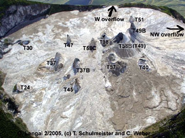 |
Figure 84. An aerial photograph taken looking towards the WSW at the summit crater of Ol Doinyo Lengai on 14 February 2005. The summit, which lies in the upper left corner has a revised elevation based on GPS (see text). In addition, GPS elevations and uncertainties suggest that in 2005 the summit was only marginally higher than the top of the tallest hornito (T56B). Copyrighted photo provided courtesy of T. Schulmeister and C. Weber. |
Geological Summary. The symmetrical Ol Doinyo Lengai is the only volcano known to have erupted carbonatite tephras and lavas in historical time. The prominent stratovolcano, known to the Maasai as "The Mountain of God," rises abruptly above the broad plain south of Lake Natron in the Gregory Rift Valley. The cone-building stage ended about 15,000 years ago and was followed by periodic ejection of natrocarbonatitic and nephelinite tephra during the Holocene. Historical eruptions have consisted of smaller tephra ejections and emission of numerous natrocarbonatitic lava flows on the floor of the summit crater and occasionally down the upper flanks. The depth and morphology of the northern crater have changed dramatically during the course of historical eruptions, ranging from steep crater walls about 200 m deep in the mid-20th century to shallow platforms mostly filling the crater. Long-term lava effusion in the summit crater beginning in 1983 had by the turn of the century mostly filled the northern crater; by late 1998 lava had begun overflowing the crater rim.
Information Contacts: Christoph Weber, Volcano Expeditions International, Muehlweg 11, 74199 Untergruppenbach, Germany (URL: http://www.v-e-i.de/); Celia Nyamweru, Department of Anthropology, St. Lawrence University, Canton, NY 13617, USA (URL: http://blogs.stlawu.edu/lengai/); Frederick Belton, Developmental Studies Department, PO Box 16, Middle Tennessee State University, Murfreesboro, TN 37132, USA (URL: http://oldoinyolengai.pbworks.com/); Bernard Donth, Waldwiese 5, 66123 Saarbruecken, Germany.