Report on Karthala (Comoros) — April 2005

Bulletin of the Global Volcanism Network, vol. 30, no. 4 (April 2005)
Managing Editor: Richard Wunderman.
Karthala (Comoros) 16 April 2005 seismicity leading to eruption; near-source tephra 1.5 m thick
Please cite this report as:
Global Volcanism Program, 2005. Report on Karthala (Comoros) (Wunderman, R., ed.). Bulletin of the Global Volcanism Network, 30:4. Smithsonian Institution. https://doi.org/10.5479/si.GVP.BGVN200504-233010
Karthala
Comoros
11.75°S, 43.38°E; summit elev. 2361 m
All times are local (unless otherwise noted)
After a long period of quiescence following the 1991 phreatic eruption, Karthala's seismicity rebounded starting in July 2000 (BGVN 25:10). In October 2000, more than 20 seismic events per day were recorded.
The local observatory and a key source for this report is the Karthala Volcano Observatory (KVO; Netter and Cheminée, 1997). They maintain close ties with the Centre National de Documentation et de Recherche Scientifique des Comores (CNDRS), Reunion Island University, the Institut de Physique du Globe de Paris, Piton de la Fournaise Volcanological Observatory, and various universities in France.
Activity during October 2000-March 2004. Between October 2000 and January 2003, relatively low seismicity was detected beneath Karthala's summit. The seismicity slowly increased. During January instruments recorded 51 earthquakes on the 5th, 58 on the 10th, and 50 on the 11th. During the month of April 2003 instruments registered 732 (i.e. averaging ~ 24 each day).
Seismic instruments detected several short earthquake swarms, each comprised of ~ 150 earthquakes. These swarms took place on 25 March and in April 2003, and each lasted several hours. Moreover, seismologists witnessed another swarm consisting of 183 events on 15 May. Except for that latter swarm, Karthala's seismicity was relatively quiet for 35 days after the 25 April swarm. A photo of the Chahalé crater from the year 2003, well before the April 2005 eruption, appears in figure 6. (For a map of Karthala's summit, see BGVN 16:08.)
 |
Figure 6. Karthala's ~ 300-m-diameter Chahalé crater as seen on 15 August 2003, more than a year prior to the April 2005 eruption. The photo was shot by the automatic camera located at the summit, looking from the NNE towards the SSW. The 2005 eruption dramatically changed this scene, replacing the green lake seen here with a lava lake, and blanketing considerable areas with tephra. Courtesy of Nicolas Villenueve. |
During the time interval from early June 2003 to January 2004 instruments registered three periods with elevated seismicity. The first interval spanned 121 days from June until the end of September 2003 and included 6,315 earthquakes. Within that interval there was a major crisis on 6th September, comprised of 345 events, some being felt by local residents (BGVN 28:08).
The second interval began on 11 October 2003, reaching its peak on 4 January 2004 (253 events) and stopped on 31 January 2004. During this interval of 113 days, instruments registered 4,431 earthquakes. The third interval, during the time period of 3 February to 5 March 2004, contained fewer earthquakes. Instruments recorded 832 events in 31 days with a maximum of 143 events per day. After the third interval, KVO recorded only low seismicity until early 2005, when daily events rose to 50-60.
Eruption during April 2005. A seismic crisis began at 0812 on 16 April. Although instruments initially received only short-period events, starting at 0914 they also registered many long-period ones. From 1055 on 16 April a continuous signal was recorded, which was interpreted as tremor marking the beginning of the eruption. At around 1400 that day inhabitants heard a rumbling coming from the volcano. A few minutes later they observed an ash column above the summit. The first ash-fall deposits began to form around 1600, developing on the island's eastern side. According to the firsts reports, ash deposition increased and continued through the night accompanied by a strong smell of sulfur.
On the morning of 17 April ash falls continued on the eastern part of the island and were heavy enough to require inhabitants to use umbrellas to get about. At midday, Jean-Marc Heintz, a pilot for Comores Aviation, flew over the west flank and observed a large plume in the direction of the Chahalé crater. He also clearly observed airborne molten ejecta.
Around 1300, observers saw a very dark plume, spreading into a mushroom shape and accompanied by lightning flashes. Some inhabitants panicked and fled the island's eastern villages. In the afternoon, residents heard rumbling. During the evening, significant rainfall generated small mudflows, and the rumbling became stronger.
At that time, authorities evacuated some eastern villages (according to Agence France Presse (AFP) this affected ~ 10,000 people). Ash there started to fall on the island's western and northern parts, notably, on the country's capital city of Moroni (~ 10 km NW of the summit) and on the Hahaya airport (~ 20 km N of Moroni, ~ 25 km NW of the summit). Figure 7 shows a photo with the base of a vigorous plume over the E flanks on the afternoon of 17 April.
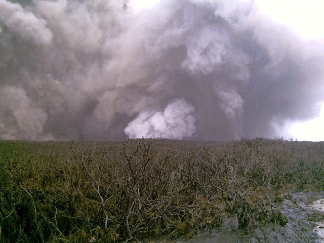 |
Figure 7. A phreatic eruption as seen from Karthala's eastern slopes on the afternoon of 17 April 2005. The vent lies below the white-colored zone in the center-right portion of the photo. With enlargement, many parts of the image record the descent of large pieces of ejecta. Photo credit to school teacher Daniel Hoffschir. |
KVO authorities sometimes witnessed a red color at the plume's base, interpreted as a sign of an ongoing magmatic eruption. At 2105 the KVO seismic network recorded a drastic decrease in the amplitude of the tremor. During the night of 17-18 April, wide variations of the tremor amplitude were recorded with a maximum at 0140 on 18 April and a minimum at 0430 on 18 April. Thereafter, the tremor amplitude did not increase. During the night of 17-18 April the plume and falling ash disappeared.
On an overflight of the Chahalé crater at 0830 on 18 April, KVO personnel observed major modifications at the summit (figures 8-10). A lava lake (figure 8) had replaced the water-bearing lake (figure 6) that had occupied the crater since 1991.
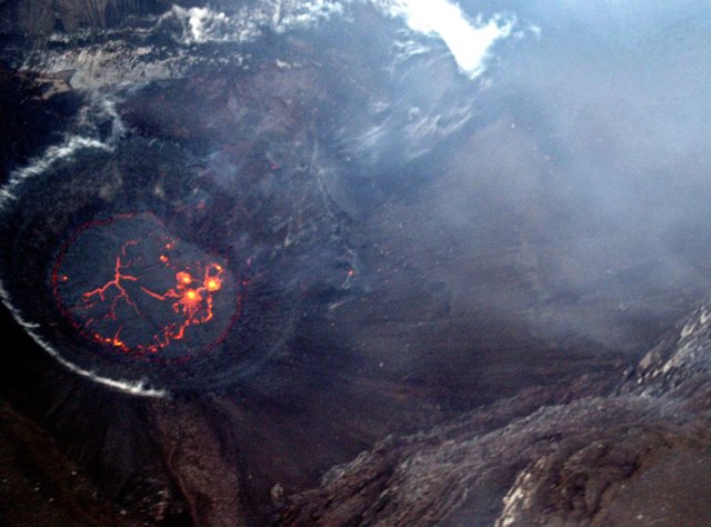 |
Figure 8. On 18 April 2005 the Karthala eruption generated a lava lake in the Chahalé crater. In this photo, taken the morning of 18 April, considerable portions of the lava lake's surface still remained molten and incandescent.. The lake's surface only remained molten for a few hours. This aerial photo was taken looking from the N. Courtesy of Hamid Soulé. |
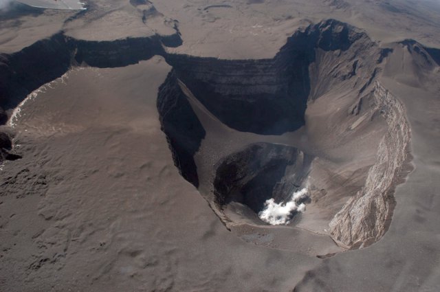 |
Figure 9. A 19 April 2005 aerial photograph of Karthala taken from the SE centered on Chahalé crater. The lava lake's surface had chilled and it emitted white vapor. Much of the summit area displays the recently deposited smooth-surfaced tephra blanket. Courtesy of Nicolas Villenueve. |
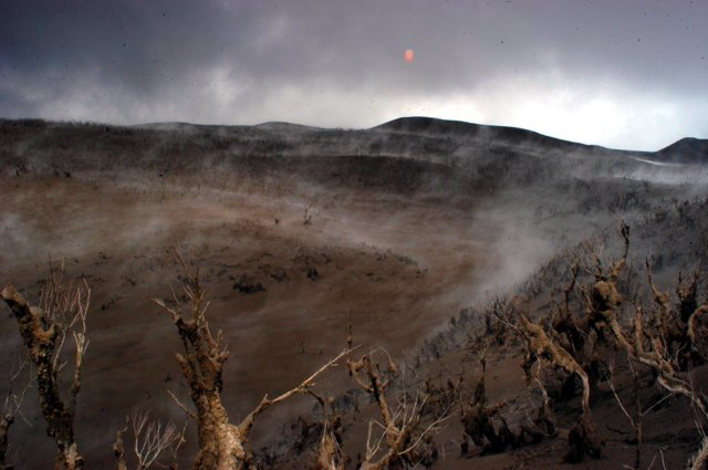 |
Figure 10. Tephra deposits left by Karthala's mid-April 2005 eruption altered the landscape and destroyed vegetation. This picture was taken at the entrance to the first caldera on the western trail, viewed looking to the S. Courtesy of Nicolas Villenueve. |
On 19 April a new overflight revealed the crater floor containing the lava lake, with its chilled surface emitting steam (figure 13). Lava remained confined to Chahalé crater. Around the caldera area, and particularly on its N, observers saw conspicuous tephra deposits; most of the vegetation had been destroyed (figure 14).
On 20 April a field excursion found that ash deposits varied in thickness from a few millimeters on the coast to ~ 1.5 m at the summit. Near the summit the observers recognized some post-eruptive evaporation and geothermal processes. Specifically, although the lava lake's surface had frozen, there remained sufficient heat under the surface that groundwater migrating towards to the crater's floor evaporated into steam. During another field survey on 8 May, observers noted the renewed presence of lake water inside the crater.
Reference. Netter, C., and Cheminée, J. (eds.), 1997, Directory of Volcano Observatories, 1996-1997: World Organization of Volcano Observatories (WOVO), WOVO/IAVCEI/UNESCO, Paris, 268 p.
Geological Summary. The southernmost and largest of the two shield volcanoes forming Grand Comore Island (also known as Ngazidja Island), Karthala contains a 3 x 4 km summit caldera generated by repeated collapse. Elongated rift zones extend to the NNW and SE from the summit of the Hawaiian-style basaltic shield, which has an asymmetrical profile that is steeper to the S. The lower SE rift zone forms the Massif du Badjini, a peninsula at the SE tip of the island. Historical eruptions have modified the morphology of the compound, irregular summit caldera. More than twenty eruptions have been recorded since the 19th century from the summit caldera and vents on the N and S flanks. Many lava flows have reached the sea on both sides of the island. An 1860 lava flow from the summit caldera traveled ~13 km to the NW, reaching the W coast to the N of the capital city of Moroni.
Information Contacts: Nicolas Villeneuve (CREGUR, Centre de Recherches et d'Etudes en Géographie de l'Université de la Réunion); Hamidou Nassor, and Patrick Bachèlery (LSTUR, Laboratoire des Sciences de la Terre), Université de La Réunion BP 7151, 15 Avenue, René Cassin, 97715 Saint-Denis, Reunion Island; François Sauvestre and Hamid Soulé, CNDRS, BP 169, Moroni, République Fédérale Islamique des Comores (URL: http://volcano.ipgp.jussieu.fr/karthala/stationkar.html).