Report on Rotorua (New Zealand) — May 2005
Bulletin of the Global Volcanism Network, vol. 30, no. 5 (May 2005)
Managing Editor: Richard Wunderman.
Rotorua (New Zealand) Hydrothermal eruption of 19 April 2005—one of the area's largest since 1948
Please cite this report as:
Global Volcanism Program, 2005. Report on Rotorua (New Zealand) (Wunderman, R., ed.). Bulletin of the Global Volcanism Network, 30:5. Smithsonian Institution. https://doi.org/10.5479/si.GVP.BGVN200505-241816
Rotorua
New Zealand
38.08°S, 176.27°E; summit elev. 757 m
All times are local (unless otherwise noted)
BGVN 26:03 reported hydrothermal activity at Rotorua on 26 January 2001 involving the ejection of mud and ballistic blocks. BGVN 28:12 reported that the New Zealand Institute of Geological and Nuclear Sciences reported two subsequent hydrothermal eruptions in Rotorua caldera at Kuirau Park around 1100 on 6 November 2003 (figure 5). The eruptions occurred just meters from the site of the large blowout in 2001. The area is known for this kind of geothermal activity. The following information is primarily from Ashley Cody.
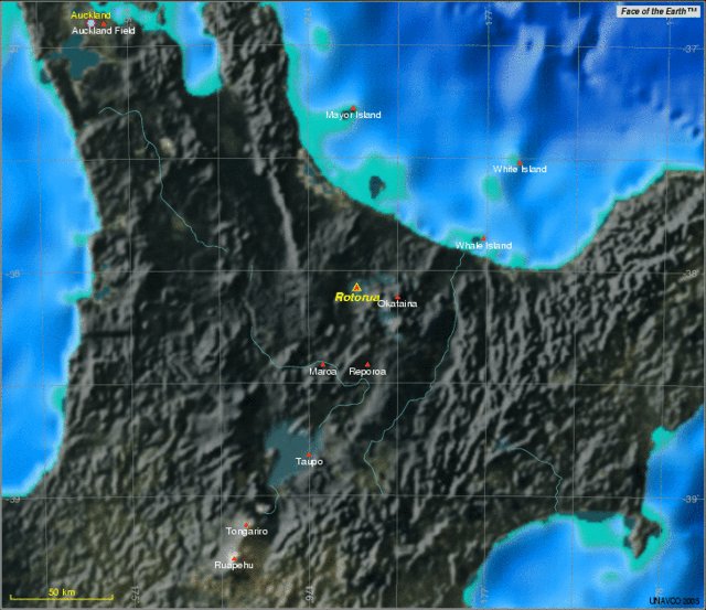 |
Figure 5. Rotorua is the NW-most caldera of the Taupo volcanic zone, in the Bay of Plenty region of New Zealand's North Island. Courtesy of UNAVCO. |
In late May 2004 a geothermal well ~ 40 m deep at Tokaanu on Lake Taupo (~ 100 km S of Rotorua) blew out suddenly, erupting mud and scalding waters to ~ 15 m high and flooding surrounding properties for several days until it could be quenched and a new headworks fitted. This well may have been standing open and just suddenly began boiling, since its casing seemed to be intact.
About 0100 on Saturday 29 June 2004 the blowout of a geothermal well in Rotorua blew muddy water and rubbly debris to ~ 15 m high and showered muck over houses and cars to a radius of ~ 100 m accompanied by noise "like a jet aircraft." It went on until about 0400 on 30 June 2004 when it was quenched with a pumped cold water supply. It was cement-grouted shut a few days later. The well was 100 m deep and cased to 47.5 m.
Starting 18 July 2004 in the early afternoon, many earthquakes were strongly felt by many people in the area ~30 km N of Rotorua and ~20 km NW from Kawerau, in the northern North Island, or central Bay of Plenty. By 23 July more than 200 earthquakes were recorded in this area, most at less than 10 km depth.
In Lake Rotoehu, about 20 km N of Rotorua city, eyewitnesses reported a water column 100 m high that occurred at the same time as a strongly-felt ML 5.4 earthquake at about 1600 on 18 July 2004 at ~5 km depth. Shortly afterward a big series of waves occurred on the lake, and swept up beaches much higher than ever seen before.
Ground rupturing was reported at several sites along southern shores of Lake Rotoehu. Many houses were evacuated due to damage such as walls breaking apart and houses shifting off their foundations. The main road was blocked in many places and more than 200 houses were evacuated due to their becoming unsafe to live in. Several people were killed by trees falling down banks onto cars and houses during the earthquakes.
On Thursday 17 March 2005 at about 1435, a blowout was observed from the northern end of Ruapeka Bay on Lake Rotorua, at Ohinemutu. It shot dark grey muddy waters and steam to ~ 6 m for 3-4 minutes. An eyewitness called the council safety inspector, Peter Brownbridge. On 18 March at about 1500, the safety inspector saw two more shots each ~ 1 m high from the same spot in the lake. This previously unknown vent is ~ 25 m NW from a clear flowing hot spring known simply as S1233, in the bed of the lake just 10 m W of the tip of Muruika Point. This is where a prehistoric account relates of a sunken village, where a sudden disturbance occurred one night and many people were killed. From verbal genealogy records, this event may have occurred about early 1700s-1720s. Today rows of timber posts are still standing below water level in the lake here.
According to a report in The Dominion Post by Mike Watson on 21 April 2005, one of the largest hydrothermal eruptions in the Rotorua area since 1948 took place about 1030 on 19 April 2005 and was witnessed by two farmers (figure 6).
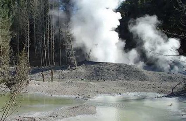 |
Figure 6. The geothermal eruption roughly midway between Rotorua and Taupo on 19 April 2005 left a 50-m wide crater. Courtesy of Ashley Cody. |
A huge column of hot steam, mud and rocks was thrown 200 m in the air. The eruption happened in an inaccessible area at Ngatamariki scenic reserve, close to the Waikato River, and about 8 km from Orakei Korako geothermal springs, roughly halfway between Taupo and Rotorua. The column was visible 10 km away and left a 50 m-wide crater and two hectares of debris. With the energy now taken out of the vent, no further eruption was expected.
The major part of the eruption lasted about two hours but it was still spewing steam up to 10 m high five hours later. The eruption sent out 7,000-10,000 m3 of material. Mud and 50 cm-diameter rocks covered a 70-100 m radius from the crater site, which had previously been covered by 2 m-high blackberry bushes and fallen trees (figure 7). The ground may take months to cool. According to Ashley Cody, the site had been heating up in the past year, with three new hot springs forming.
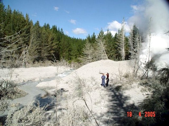 |
Figure 7. The hydrothermal eruption roughly halfway between Taupo and Rotorua left ash and mud covering the surrounding area to a depth of 4 m (light-colored material on ground surface, coating some trees, and choking the stream). Courtesy of Ashley Cody. |
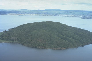
Geological Summary. The 22-km-wide Rotorua caldera is the NW-most caldera of the Taupo volcanic zone. It is the only single-event caldera in the Taupo Volcanic Zone and was formed about 220,000 years ago following eruption of the more than 340 km3 rhyolitic Mamaku Ignimbrite. Although caldera collapse occurred in a single event, the process was complex and involved multiple collapse blocks. The major city of Rotorua lies at the south end of the lake that fills much of the caldera. Post-collapse eruptive activity, which ceased during the Pleistocene, was restricted to lava dome extrusion without major explosive activity. The youngest activity consisted of the eruption of three lava domes less than 25,000 years ago. The major thermal areas of Takeke, Tikitere, Lake Rotokawa, and Rotorua-Whakarewarewa are located within the caldera or outside its rim, and the city of Rotorua lies within and adjacent to active geothermal fields.
Information Contacts: Ashley Cody, Consulting Geologist, 10 McDowell Street, Rotorua, New Zealand; Ron Keam, Physics Department, The University of Auckland, Private Bag 92-019, Auckland, New Zealand; Mike Watson, The Dominion Post.