Report on Rabaul (Papua New Guinea) — July 2005

Bulletin of the Global Volcanism Network, vol. 30, no. 7 (July 2005)
Managing Editor: Edward Venzke.
Rabaul (Papua New Guinea) Continuing low-level eruptions and ash emissions
Please cite this report as:
Global Volcanism Program, 2005. Report on Rabaul (Papua New Guinea) (Venzke, E., ed.). Bulletin of the Global Volcanism Network, 30:7. Smithsonian Institution. https://doi.org/10.5479/si.GVP.BGVN200507-252140
Rabaul
Papua New Guinea
4.2459°S, 152.1937°E; summit elev. 688 m
All times are local (unless otherwise noted)
As of July 2004 Tavurvur was releasing white vapor in variable amounts, seismicity was at a low level, and ground deformation continued as slow uplift (BGVN 29:07). Eruptive activity had stopped months earlier, in February 2004 (BGVN 29:04).
On 25 January 2005 ash rose to ~ 500 m above the summit and drifted E. Another ash emission on 31 January reached ~ 1 km above the summit but was not visible on satellite imagery. During 1-21 February, frequent eruptions of ash clouds rose a few hundred meters, drifted SE, and deposited ash mainly offshore. However, ashfall was reported in the town of Tokua during 18-21 February. Incandescent lava fragments were visible on several evenings. Between 200 and 350 daily earthquakes were associated with the eruptions. The number of seismic events leveled off around 20 February to between 150 and 200 per day. During 22-24 February ash fell offshore, but there were also reports of fine ash reaching Tokua airport.
Low-level eruptions continued during the first two weeks of March. During 22-28 March, eruptions continued every 10-20 minutes. Ash clouds rose several hundred meters above the summit, and moderate ash fell in Rabaul Town during 25-28 March. There were 100-200 daily earthquakes associated with the eruptions. No changes were recorded in ground deformation.
During April, May, and most of June 2005, low-level eruptive activity consisted of occasional emission of diffuse pale gray to gray ash clouds, which rose a few hundred meters above the summit. On 1-5, 17-22, and 25-30 April the ash clouds were blown NNW; on 6-16 and 23-24 April they drifted ESE. Fine ashfall occurred over Rabaul Town and villages downwind. Occasional roaring noises were heard throughout April. The daily average number of low-frequency seismic events increased from about 40 during the first half of the April to about 100 in the second half. One high-frequency event, on 26 April, was located NE of the caldera. Ground deformation indicated an inflationary trend. The real-time GPS site on Matupit Island, in the center of the caldera, has shown an inflationary trend since January 2005.
Photographs taken by visitors to Rabaul in late May to early June documented activity from two separate vents at Tavurvur. On 25 May there were two distinct plumes, one a very dark, coherent, ash column and the other a more diffuse white or light gray emission; the plumes appeared to mix a short distance above the volcano (figure 40). A single larger gray plume was seen on 5 June (figure 41). On 27 June the Darwin VAAC received a pilot report of an ash plume 37 km to the NW of the volcano. A pilot observed an ash plume from Rabaul on 28 July at a height of 3 km, but ash was not visible on satellite data.
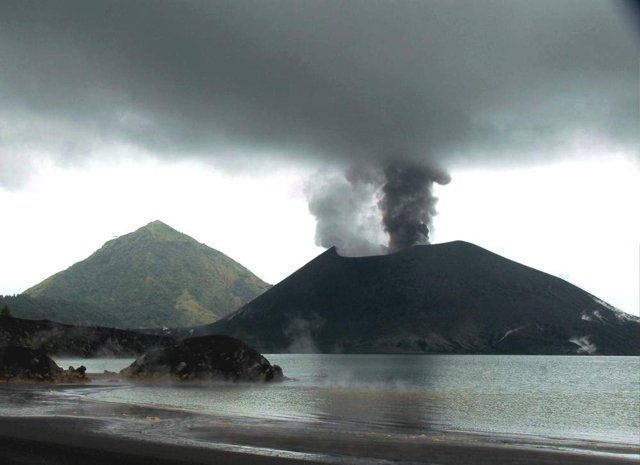 |
Figure 40. Photograph showing an eruption of the Tavurvur cone at Rabaul looking from the NW across Matupi Harbor on 25 May 2005. Two plumes, one white and the other dark gray, are originating from separate vents. The peak in the background is Turanguna. Courtesy of Roy Price. |
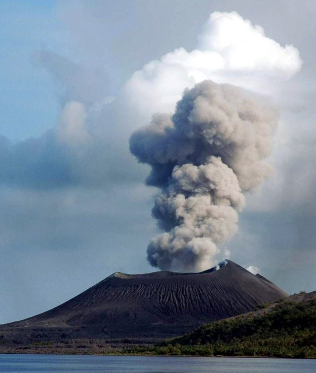 |
Figure 41. Photograph showing an eruption of the Tavurvur cone at Rabaul looking from the SE on 5 June 2005. The single large plume in this view was darker gray in the upper portion and lighter gray in the lower portion. White clouds above the plume appear to be meteorological clouds. Courtesy of Roy Price. |
On 9 August, a low-level ash plume at an altitude of 1.5 km was visible on a satellite image of Rabaul. As of mid-August Tavurvur continued to erupt with discrete ash emissions, although their frequency had declined and most were less vigorous. Some of the of ash-laden clouds were also lighter in color, suggesting less ash content. Ash plumes rose between 800 and 1,500 m and drifted N and NW, occasionally depositing ash on the E part of Rabaul Town and in areas farther downwind. Roaring and rumbling noises accompanied the activity. Projections of incandescent lava fragments were visible at night but were less conspicuous compared to the previous week. Seismicity was at a moderate to high level with most earthquakes associated with ash emissions and explosions. However, small low-frequency earthquakes not associated with ash emissions were also recorded. No high-frequency earthquakes were recorded. Ground deformation measurements from GPS and tide gauge instruments fluctuated, but the general trend showed a slow rate of uplift. As a safety precaution, people continue to be discouraged from venturing within 1 km of the erupting vent.
Geological Summary. The low-lying Rabaul caldera on the tip of the Gazelle Peninsula at the NE end of New Britain forms a broad sheltered harbor utilized by what was the island's largest city prior to a major eruption in 1994. The outer flanks of the asymmetrical shield volcano are formed by thick pyroclastic-flow deposits. The 8 x 14 km caldera is widely breached on the east, where its floor is flooded by Blanche Bay and was formed about 1,400 years ago. An earlier caldera-forming eruption about 7,100 years ago is thought to have originated from Tavui caldera, offshore to the north. Three small stratovolcanoes lie outside the N and NE caldera rims. Post-caldera eruptions built basaltic-to-dacitic pyroclastic cones on the caldera floor near the NE and W caldera walls. Several of these, including Vulcan cone, which was formed during a large eruption in 1878, have produced major explosive activity during historical time. A powerful explosive eruption in 1994 occurred simultaneously from Vulcan and Tavurvur volcanoes and forced the temporary abandonment of Rabaul city.
Information Contacts: Ima Itikarai and Herman Patia, Rabaul Volcano Observatory (RVO), P. O. Box 386, Rabaul, Papua New Guinea; Darwin Volcanic Ash Advisory Center, Bureau of Meteorology, Northern Territory Regional Office, PO Box 40050, Casuarina, Northern Territory 0811, Australia; Roy E. Price, Geology Department, University of South Florida, 4202 East Fowler Ave., Tampa, FL 33620, USA.