Report on Concepcion (Nicaragua) — July 2005
Bulletin of the Global Volcanism Network, vol. 30, no. 7 (July 2005)
Managing Editor: Edward Venzke.
Concepcion (Nicaragua) Eruption on 28 July 2005 deposits ash in nearby towns
Please cite this report as:
Global Volcanism Program, 2005. Report on Concepcion (Nicaragua) (Venzke, E., ed.). Bulletin of the Global Volcanism Network, 30:7. Smithsonian Institution. https://doi.org/10.5479/si.GVP.BGVN200507-344120
Concepcion
Nicaragua
11.538°N, 85.622°W; summit elev. 1700 m
All times are local (unless otherwise noted)
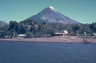
According to the Instituto Nicaraguense de Estudios Territoriales (INETER) an eruption occurred at dawn on 28 July 2005 from Concepción, which lies on the island of Ometepe in W-central Lake Nicaragua (figure 3). Concepción is frequently active at low levels and INETER reports suggested these new events as late as 31 July were not considered major behavioral anomalies indicative of an energetic reactivation of the volcano. A colored diagrammatic map that for the case of larger eruptions included hazard zones, refuges, and escape routes for three contingencies; it appeared in the press several days before the July eruption. Many of the scenarios indicated movement of people to the SE side of the island. The map noted that Concepción has 26 craters, and eruptions could occur from other than the central vent.
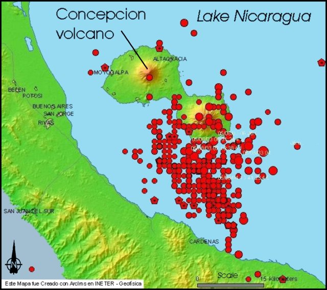 |
Figure 3. A map of the portion of Lake Nicaragua containing Ometepe island, the northern portion of which includes Concepción volcano. Eruptions there in late July led to ash falling on many of the labeled settlements to the W of the summit. Small dots represent epicenters detected during 2003-2005; they mainly centered 10-16 km to the SE and often off the island, but typically closer to the island's other volcano (Maderas). The largest were MR 5.6 (date not given). Courtesy of INETER. |
The 28 July eruption cloud deposited ash in the island town of Moyagalpa (~ 9 km W of the summit) and in lesser quantities on the mainland settlements W of the volcano, at San Jorge, Buenos Aires, Potosí, Belén, and in the vicinity of Rivas. Residents also smelled volcanic gases.
INETER recorded seismic tremor at a station N of the volcano, but no large earthquakes occurred. By the afternoon of 28 July ashfall had reduced considerably, or completely ceased, but gas emission continued. No thermal anomalies were observed on satellite imagery. During the night and the following day residents on Ometepe island's W side reported continued presence of ash and gas.
On the morning of 29 July, geodetic measurements determined that significant deformation had occurred, presumably related to magma injected. The seismic station to the N recorded constant tremor; during 0500-0800, a series of volcanic earthquakes may have been associated with small explosions in the crater. At 1025 the seismic station recorded a moderate explosion in the crater.
On 30 July the N seismic station registered tremor, which continued with variations. Significant earthquakes remained absent. On 31 July after 0300 tremor amplitude rose and it remained elevated for an undisclosed amount of time. However, episodes of ashfall diminished or ceased.
Geological Summary. Volcán Concepción is one of Nicaragua's highest and most active volcanoes. The symmetrical basaltic-to-dacitic stratovolcano forms the NW half of the dumbbell-shaped island of Ometepe in Lake Nicaragua and is connected to neighboring Madera volcano by a narrow isthmus. A steep-walled summit crater is 250 m deep and has a higher western rim. N-S-trending fractures on the flanks have produced chains of spatter cones, cinder cones, lava domes, and maars located on the NW, NE, SE, and southern sides extending in some cases down to Lake Nicaragua. Concepción was constructed above a basement of lake sediments, and the modern cone grew above a largely buried caldera, a small remnant of which forms a break in slope about halfway up the N flank. Frequent explosive eruptions during the past half century have increased the height of the summit significantly above that shown on current topographic maps and have kept the upper part of the volcano unvegetated.
Information Contacts: Instituto Nicaraguense de Estudios Territoriales (INETER), Volcanology Department, Apartado 2110, Managua, Nicaragua (URL: http://www.ineter.gob.ni//vol/concepcion/concepcion.html).