Report on Bagana (Papua New Guinea) — August 2005

Bulletin of the Global Volcanism Network, vol. 30, no. 8 (August 2005)
Managing Editor: Richard Wunderman.
Bagana (Papua New Guinea) Lava flows and occasional ash plumes during April-September 2005
Please cite this report as:
Global Volcanism Program, 2005. Report on Bagana (Papua New Guinea) (Wunderman, R., ed.). Bulletin of the Global Volcanism Network, 30:8. Smithsonian Institution. https://doi.org/10.5479/si.GVP.BGVN200508-255020
Bagana
Papua New Guinea
6.137°S, 155.196°E; summit elev. 1855 m
All times are local (unless otherwise noted)
Bagana was last reported on in June 2004 (BGVN 29:06) summarizing MODIS thermal alerts during 1 January 2001-31 May 2004. Lava flows, which had erupted at an unknown time, were described in BGVN 29:05. Bagana has been in long-term eruption since 1972, but the volcano's remote location and intervals of separatist conflict on the island had restricted access by observatory staff, and subsequent reports remained infrequent. Several Rabaul Volcano Observatory (RVO) reports addressed Bagana volcanism during March-September 2005, revealing conditions seen on the ground. There were numerous MODVOLC thermal alerts posted for Bagana during the reporting interval. The rest of the reports relied on satellite-based observations of plumes produced for the purpose of aircraft safety.
RVO noted that during April 2005 Bagana continued its effusive eruption of lava. The summit crater released weak to moderate volumes of thick white vapor on most days. Occasional gray to brown ash plumes were reported. White vapor was visible in some areas of the SW flank. Summit glow was visible on most nights when it was clear, associated with the active lava flow on the upper S flanks. White vapor visible on the upper SW flank during daytime was also associated with a lava flow. Occasional loud roaring noises like jet engines and booming noises were heard on 17, 19, and 30 April. Some of the noises accompanied emission of thick, dark gray ash clouds.
According to the Darwin Volcanic Ash Advisory Centre (VAAC), on 17 March 2005 at 0726 a very small plume to ~ 2.4 km altitude and hot spot were visible on satellite imagery. Satellite imagery at 0551 on 13 May revealed a thin plume extending 28 km ESE below 3 km altitude. Similar plumes, blowing W, were identified at 0537 on 14 May and at 0634 on 15 May.
A plume from Bagana was observed in satellite imagery for 8 June. Darwin VAAC stated that the plume initially extended 65 km WSW, then W later in the day. The height of the plume was not stated. US Air Force Weather Agency analysts indicated that at 0955 local time on 8 June (2355 UTC on 7 June) the plume extended at least ~ 38 km W, rising up to ~ 3 km, and the MODIS image they provided showed four volcanoes in the region all emitting plumes (figure 7).
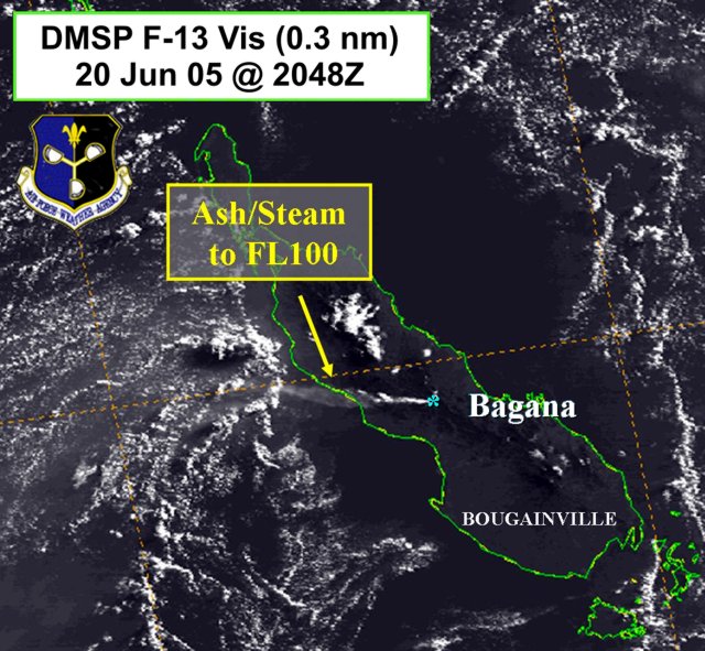 |
Figure 7. A DMSP image highlighting a Bagana plume seen on 20 June 2005. For scale, near its broad SE end, Bougainville island is ~50 km wide (measured in the NE-SW direction). Both images provided courtesy of NASA and the US AFWA. |
During 13-19 June, Bagana was relatively quiet with variable amounts of white vapor emitted from the crater. Weak projections of incandescent lava were visible until 17 June. During 8-10 June, several low-level plumes emitted from Bagana were visible on satellite imagery extending mainly to the WSW. A plume from Bagana visible on satellite imagery on 21 June extended W. The height of the plume was not reported. A thin plume emitted from Bagana was visible on satellite imagery on 30 June. The height of the plume was not reported.
During 10-16 August, the Darwin VAAC reported that satellite observations showed an ash plume from Bagana visible at a height of ~ 3 km, extending ~ 40 km SW of the summit. Ash was not visible on the image.
During 15-21 August, volcanic activity at Bagana remained at low levels. Variable amounts of thick white vapor were emitted from the summit crater. During several nights, dull-to-moderately bright incandescence was visible. Occasional low roaring noises were heard on 15 and 20 August. At night dull to moderately bright glow was visible on 16, 18, 20, and 21 August. On 20 August, lava flowed from the main crater. Incandescent lava avalanches occasionally originated from unstable areas of the lava flow.
Between 22 and 28 August 2005, Bagana was quiet. The summit crater released variable amounts of white vapor throughout. Continuous roaring noises were heard during a 30-minute period on 23 August, and bright glow was visible the nights of 23 and 24 August. There was a single expulsion of a thick dark ash plume on 24 August.
During 12-18 September 2005, occasional small volumes of ash escaped, and emissions consisted chiefly of weak to moderate volumes of white vapor. Beginning on 17 September occasional sub-continuous booming noises commenced. Some of the booming noises were accompanied by forceful emissions of whitish-brown ash clouds. This activity continued on 18 September. Ash plumes from the activity drifted to W and NW resulting in fine ashfall in downwind areas. Occasional sub-continuous jet-like noises began to occur on 18 September along with a reported lava flow. Glow was observed at night on 14 and 18 September. This could have been associated with cascading lava detached from steep portions of an active lava flow.
The seismograph remained off from 15 August onward through the reporting period due to technical problems.
Geological Summary. Bagana volcano, in a remote portion of central Bougainville Island, is frequently active. This massive symmetrical cone was largely constructed by an accumulation of viscous andesitic lava flows. The entire edifice could have been constructed in about 300 years at its present rate of lava production. Eruptive activity is characterized by non-explosive effusion of viscous lava that maintains a small lava dome in the summit crater, although occasional explosive activity produces pyroclastic flows. Lava flows with tongue-shaped lobes up to 50 m thick and prominent levees descend the flanks on all sides.
Information Contacts: Rabaul Volcano Observatory (RVO), P.O. Box 386, Rabaul, Papua New Guinea ; Darwin Volcanic Ash Advisory Centre (VAAC), Bureau of Meteorology, Northern Territory Regional Office, PO Box 40050, Casuarina, Northern Territory 0811, Australia (URL: http://www.bom.gov.au/info/vaac/).