Report on Anatahan (United States) — August 2005

Bulletin of the Global Volcanism Network, vol. 30, no. 8 (August 2005)
Managing Editor: Richard Wunderman.
Anatahan (United States) Surge photographed on 24 August; eruption halts on 3 September
Please cite this report as:
Global Volcanism Program, 2005. Report on Anatahan (United States) (Wunderman, R., ed.). Bulletin of the Global Volcanism Network, 30:8. Smithsonian Institution. https://doi.org/10.5479/si.GVP.BGVN200508-284200
Anatahan
United States
16.35°N, 145.67°E; summit elev. 790 m
All times are local (unless otherwise noted)
Anatahan has erupted almost continuously since 5 January 2005, when it started a new episode of vigorous discharges. A summary of satellite images during 16 June-20 July 2005 (BGVN 30:07) showed that it was one of the most conspicuous eruptions on the planet in 2005.
Eruptions somewhat abruptly ceased on about 3 September. Significant discharges remained absent through as late as 29 September. Activity described below through early September is based on an array of material from numerous sources, including the US Geological Survey (USGS), the Washington VAAC, the U.S. Air Force Weather Agency (AFWA), the press, and the Emergency Management Office of the Commonwealth of the Northern Mariana Islands (EMO-CNMI).
Following the general discussions of activity, a report is included contributed by Setsuya Nakada from the Earthquake Research Institute (ERI), University of Tokyo, whose team of scientists made close-range observations of a distinctive eruptive phase called an ash-cloud surge from a helicopter on 24 August. On that day they documented the surge as a robust sub-horizontal plume slowly traveling over, and in contact with, the ocean surface.
Activity during August 2005. Throughout August eruptive activity continued, with plumes rising several thousand meters above the volcano. On 1 August and during 3-9 August the National Weather Service at Tiyan, Guam, issued numerous reports for the islands of Saipan and Tinian.
On 1 August a strong sulfur odor was reported by numerous residents, and ash was observed on aircraft at Saipan International Airport. According to a news article, flights leaving the airport were delayed.
A 4 August article published in the Saipan Tribune by John Ravelo was entitled "Engine trouble forces aircraft's emergency landing." What follows comes from the opening paragraphs of that article, describing events attributed to 3 August.
"An aircraft suffered engine trouble in mid-air early last night shortly after taking off from the Saipan International Airport, prompting it to return to the tarmac for emergency landing. The Ports Police said no one was injured in the incident. This happened as Saipan, Tinian and Rota remained under volcanic haze from Anatahan until last night . . ..
"The aircraft reportedly left the Saipan airport at approximately 6 pm. Minutes later, at about 6:15 pm, Ports Police on-duty airport supervisor Sgt. Greg Arriola said his office received a call that the aircraft was coming back due to 'problems with its left engine.'
"'The aircraft landed safely. Everybody was safe,' Arriola said. He refused to elaborate and name the aircraft, saying, 'we're still checking [on] the matter.'
"Arriola did not disclose the number of passengers aboard the distressed aircraft and where the plane was supposedly bound. The haze over Saipan has resulted in flight interruptions since Monday [1 August], temporarily stranding hundreds of passengers.
"According to the U.S. Geological Survey, volcanic ash threatens jets ... as it forms deposit in engines, restricts airflow, and clogs fuel nozzles. Minute particles of volcanic ash also contaminate aircraft's ventilation, lubrication, hydraulic and electronic systems. They cause erosion and pitting of leading edges of windshields and landing lights, as well as erosion of compressor blades."
The USGS and EMO noted that a seismic station on Sarigan, Anatahan's neighboring island 6.5 km to the W, recorded more than 40 earthquakes on 9 August, three of which had magnitudes of around 4. The seismic swarm began at around 0152 and occurred over the next eight hours. At around 0539, an M 4.2 earthquake occurred, and the National Earthquake Information Center traced the event to ~ 65 km NW of Anatahan.
Tremor and long-period earthquakes were recorded through 8 August. Later, an ash plume was detected on satellite imagery by the AFWA and Washington VAAC; it was at 5-5.5 km altitude extending approximately 220-400 km NW from the summit on 9 August. A Washington VAAC report that day was the 650th Anatahan report they had issued in 2005.
During the remainder of August 2005, eruptive activity continued and ash plumes rose to 6-8 km altitude. Volcanic tremor levels ranged between 20 and 65 percent of peak levels, and long-period earthquakes occurred sporadically. But, after around 0205 on 27 August, the seismic station went off-line. During 1-3 September activity continued, with ash plumes rising to a maximum of ~ 3 km altitude.
Eruptions halt on 3 September 2005. The USGS reported that based on remote-sensing data Anatahan appeared to have stopped erupting on 3 September (UTC), and initial data documenting that circumstance represented observations between 0901 and 2308 UTC. The earlier time corresponded to when AFWA last noted visible ash on a GOES 9 image. Ash could not be detected in satellite imagery through 1825 UTC due to cloud cover. A pilot report at 2308 UTC on 3 September indicated "no activity was occurring at the volcano." The Washington VAAC reported that no ash was detected in satellite imagery through 0025 UTC on 4 September under mostly clear skies. MODIS imagery at 0040 and 0345 UTC on 4 September also show no discernible ash being erupted under clear skies.
This was the first time that the USGS and the EMO reported an absence of volcanism on Anatahan since ash-bearing discharges started in early January 2005. Since then, tremor levels have been fluctuating, with occasional Strombolian explosions.
During an overflight the week of 7 September, USGS and EMO personnel did not see any ash emissions, only low-level steam-and-gas emissions. They noted that the crater floor was covered by sediment-laden water. In East Crater they saw an active geothermal system, consisting of mud pots, mini-geysers, and steam jetting from the crater walls.
Although volcanic seismicity was at low levels through at least 16 September, according to the World Data Center for Seismology (Denver, Colorado) a M 4.4 earthquake struck the Saipan region of the Northern Mariana Islands on 9 September 2005. It occurred at about 1301 local time, with the epicenter 80 km SSW of Anatahan.
Eruption observations, 24 and 26 August 2005. The following describes a 24 August helicopter visit to the vicinity of Anatahan, which included witnessing and documenting eruptive phenomena, but not landing. Photos were also taken on 26 August while passing well to windward of the island on a commercial airliner. The report was submitted by Setsuya Nakada, who was accompanied from Japan by colleagues Takeshi Matsushima (Institute of Seismology and Volcanology, Kyushu University), and Mitsuhiro Yoshimoto (Volcano Research Center, Earthquake Reserch Institute, University of Tokyo).
They had hoped to recover GPS and tiltmeter data from stations on Anatahan, and to find, exhume, inspect, and repair any ash-covered instruments. These instrumental data span the important period starting from last year, an interval that could shed light on the behavior of the volcano and the magma system during the eruption. Geological inspection and petrological sampling were also planned.
Anatahan's seismicity changed from continuous, strong signals to undergoing intermittent pulsations around the morning of 23 August, and a large (M 4.8?) LP earthquake occurred at 2045 on 23 August. Judging from this sudden seismological change and the LP event, the USGS scientists monitoring the seismicity (Andy Lockhart, Randy White, and others) suggested suspending landing on the island for at least a few weeks.
The team decided to fly over the island without landing to assess the state of burial of their geodetic observation site. They spent about an hour in the air there (about 1000 to 1100 on the 24th) viewing and photographing the scene. Besides the pilot, the helicopter carried Nakada, Matsushima, Yoshimoto, and Juan Camacho (EMO-CMI).
During the 24 August visit, dense ash clouds issued very vigorously from the active E crater. The cloud and hung over the summit calderas, their SW rims, and swept out over the sea to the SW and W of the island.
The photographs and the impressions of Camacho and his pilot from visits in July and May 2005 suggested that the activity level was higher on 24 August. The flight disclosed an island completely covered with thick layers of both wet (dark and probably very fine) ash deposits, and fresh dry ones on the island's S slopes. The dry ones lay under the ash cloud. Green areas were restricted to spots on the outer slopes. Many gullies had begun to develop on the surface of the thick ash deposit.
The observers saw a dark eruption cloud (densely ash-laden) vigorously blasting out of the active crater. A heavy ash cloud hung over the island (figures 21 and 22). The eruption cloud rose to ~ 800 m directly above the crater, and it increased up to ~ 2,000 m over the W part of the island, where it became lighter in color. Darker, vigorous emissions also came from the east crater's W side or NW side, and less frequently from its E side. Though this may have reflected the complex circulation of air within the east crater, another possibility was that the active crater had widened recently, especially to the E. Two ash emission points may have developed inside the large active crater.
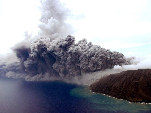 |
Figure 21. View of Anatahan and plumes looking NW, taken from a helicopter around 1000 on 24 August 2005. The windward area is mantled with a light-colored, low hanging plume (far right). A large dark plume emerges from the vent (east crater); as it hugged the sea surface it advanced roughly horizontally and comparatively slowly A spike of light-colored cloud rises above the darker plume, over an area over the sea but not far from the island. Courtesy of T. Matsushima. |
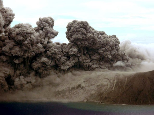 |
Figure 22. View of Anatahan looking from the S taken during the helicopter inspection around 1000 on 24 August. In addition to the eruptive clouds, this photo includes the eruptive vent area and some portions of the tephra covered island. Courtesy of T. Matsushima. |
Seismic amplitudes during the flight were weaker than recorded the afternoon of 23 August. Seismic signals consisted of intermittent pulses with duration intervals from 5 to 20 minutes. Such signals could presumably have corresponded with a series of Strombolian explosions, but on the flight these were not seen. No projectiles were observed—even near the base of the eruption cloud—although the vent was obscured by a profusion of drifting clouds (figures 1 and 2). Abundant ash-laden clouds passed vigorously and continuously from the active crater, escaping in cycles of five's to ten's of minutes in duration, intervals seemingly similar to the seismicity during the flight.
Abundant ash fell from the dark ash cloud that drifted to the SW of the crater. Around 1000 a ring of ash-cloud surge expanded on the crater's southern rim. It advanced comparatively slowly, traveling SW (figures 21 to 24). Along the sea surface, many small lobes of ash cloud developed, moving slowly. These were reminiscent of lobes seen in surges observed at the Tar River Valley delta during the Soufrière Hills eruption. These eruptive scenes also appeared very similar to those observed on 29 August 2000 at Miyake-jima (Nakada and others, 2005a), where a low-temperature ash-cloud surge moved slowly from the summit crater. In the case of the ash-cloud surge seen at Anatahan, it may be that the passage across sea water had a profound influence, triggering behavior more closely phreatomagmatic than purely magmatic in character. The ash-cloud surge took place mainly as the observers approached the island. The surge was thought to correlate to an interval of elevated seismicity.
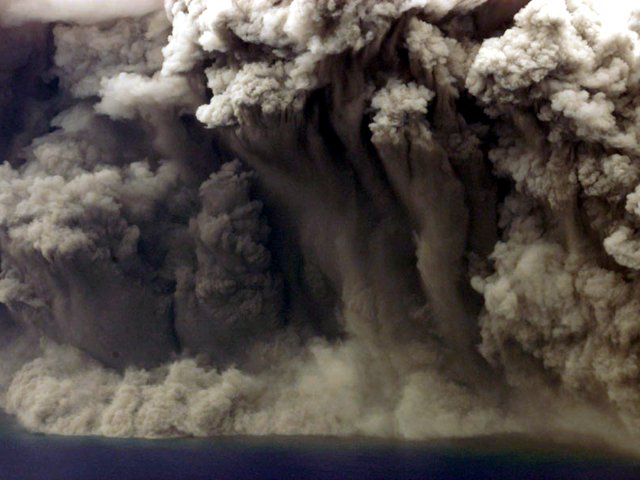 |
Figure 23. A close-up photograph documenting ash-cloud complexities from the eruption at Anatahan at about 1000 on 24 August. Looking N, the photo focused on a part of the dark ash cloud above the ocean. The plume is both dropping ash and billowing upwards. Along the cloud base and adjacent the ocean surface grew a light-colored fringe of expanding clouds. Courtesy of S. Nakada. |
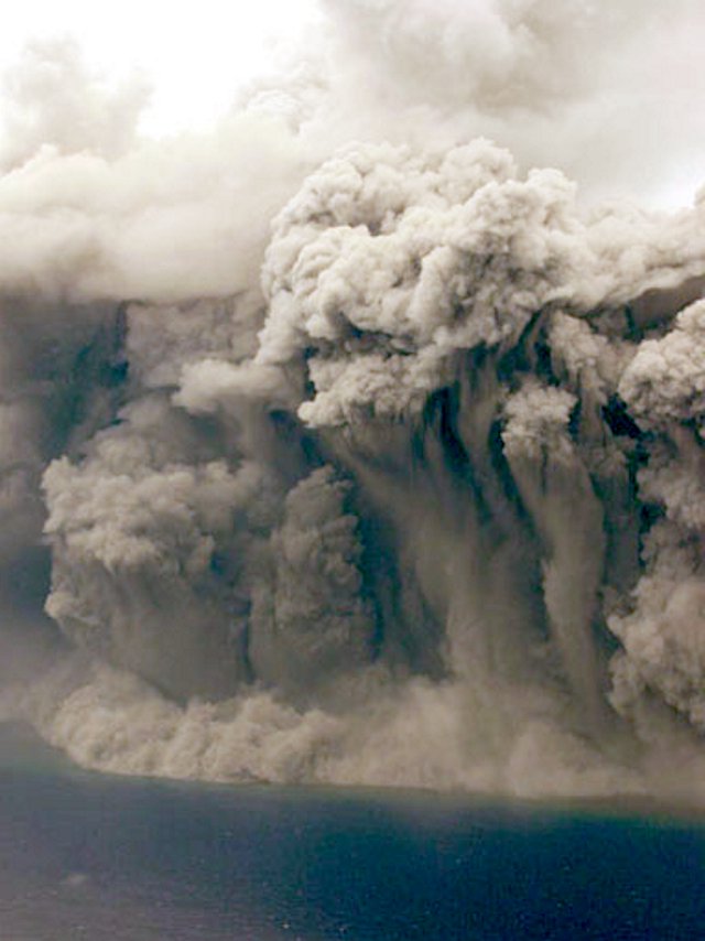 |
Figure 24. A N-looking photo of the 24 August eruption at Anatahan that is similar to the previous one, but better illustrating the rising upper portions of the dark ash cloud. Courtesy of M. Yoshimoto. |
Tephra buried portions of the village ~ 7 km W of the active crater and reached 1.5 m thick. A photograph revealed that the GPS antenna, within a 50-cm-high pillar, remained distinct even though under considerable ash. The cable to the computer was also partly visible inside a collapsed hut, suggesting the prospect of still retrieving the data. The GPS end-point station ~ 1.5 km E of the crater was under a ~ 1-m-thick blanket of ash, but again the GPS antenna was seen on the edge of a small pond.
A thermal imaging camera system took an essentially simultaneous thermal (infrared) image and a visible-light photograph (figure 25). The eruption cloud was too dense to capture the temperature distribution near the floor of the crater area. Instead, the images represented only the temperature distribution of the cooler, outer portions of the clouds, where temperatures ranged from 19.5 to 27°C (figure 25).
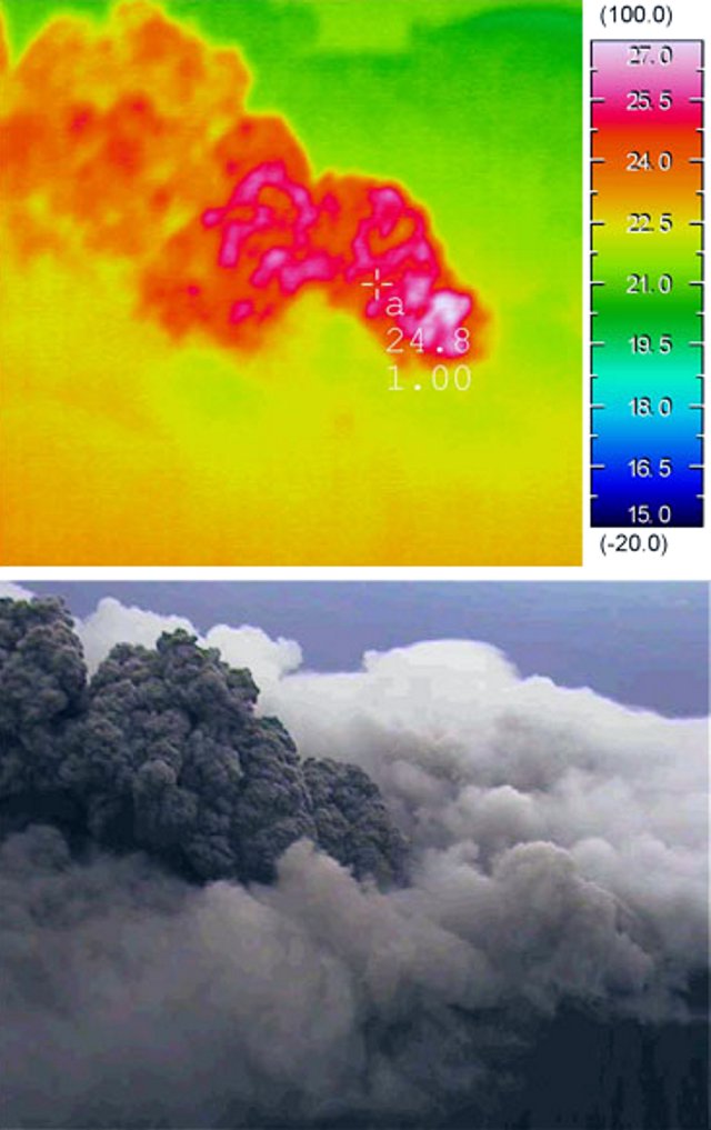 |
Figure 25. Anatahan's vent area emitting copious rising clouds as recorded in both a conventional (visible wavelength) photograph and a nearly simultaneous (infrared wavelength) thermal image. The photographer was looking northward from S of the crater around 1100 on 24 August. The shots were made with a thermal imaging camera (Thermo Tracer TH9100MV, NEC San-Kei Instruments, Ltd.) that takes the thermal and visual images in rapid succession. Courtesy of M. Yoshimoto. |
As Nakada and colleagues departed from the Mariana Islands, Anatahan's eruption was seen again (figure 26), this time from a commercial air flight (Northwest Airlines' flight NW0078) traveling from Saipan to Nagoya and departing at 0930 on 26 August 2005. The plume was directed SW. In addition to the very different plume morphology seen that day, the eruptive intensity was judged to have been higher than on 24 August (figure 26).
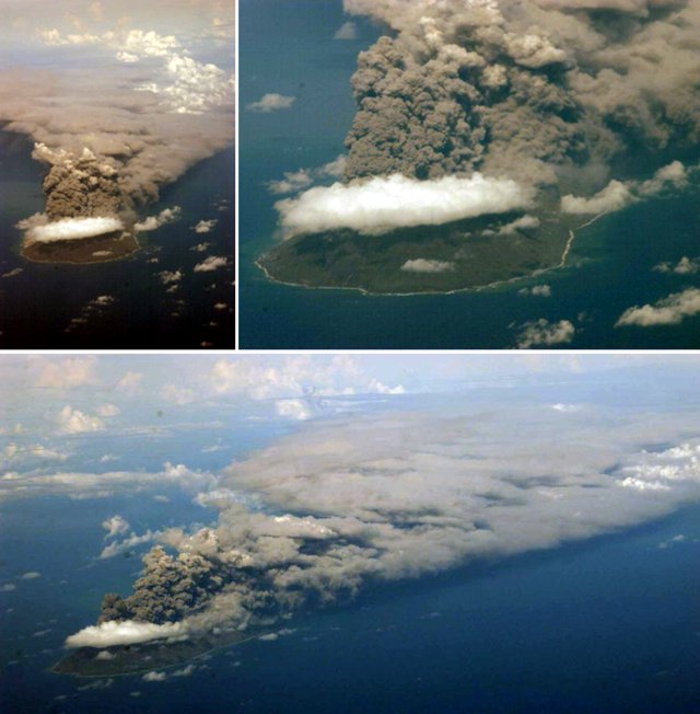 |
Figure 26. Three views of Anatahan looking SW as it discharged a large, buoyant ash plume on 26 August 2005. Photographs were taken en route from Saipan (CMI) to Nagoya (Japan). Courtesy of S. Nakada. |
References. Hilton and others, 2005, Introduction to the special issue on the 2003 eruption of Anatahan Volcano, Commonwealth of the Northern Marianas Islands (CNMI): Jour. Volcanol. Geotherm. Res., v. 146, p. 1-7.
Nakada and others, 2005a, Chronology and products of the 2000 eruption of Miyakejima Volcano, Japan: Bull. Volcanol., v. 67, p. 205-218.
Nakada and others, 2005b, Geological aspects of the 2003-2004 eruption of Anatahan Volcano, Northern Mariana Islands: Jour. Volcanol. Geothermal. Res. 146, p. 226-240.
Watanabe and others, 2005, Geodetic constraints for the mechanism of Anatahan eruption of May 2003: Jour. Volcanol. Geothermal. Res., v. 146, p. 77-85.
Geological Summary. The elongate, 9-km-long island of Anatahan in the central Mariana Islands consists of a large stratovolcano with a 2.3 x 5 km compound summit caldera. The larger western portion of the caldera is 2.3 x 3 km wide, and its western rim forms the island's high point. Ponded lava flows overlain by pyroclastic deposits fill the floor of the western caldera, whose SW side is cut by a fresh-looking smaller crater. The 2-km-wide eastern portion of the caldera contained a steep-walled inner crater whose floor prior to the 2003 eruption was only 68 m above sea level. A submarine cone, named NE Anatahan, rises to within 460 m of the sea surface on the NE flank, and numerous other submarine vents are found on the NE-to-SE flanks. Sparseness of vegetation on the most recent lava flows had indicated that they were of Holocene age, but the first historical eruption did not occur until May 2003, when a large explosive eruption took place forming a new crater inside the eastern caldera.
Information Contacts: Juan Takai Camacho and Ramon Chong, Emergency Management Office of the Commonwealth of the Northern Mariana Islands (EMO-CNMI), PO Box 100007, Saipan, MP 96950, USA (URL: http://www.cnmihsem.gov.mp/); Charles Holliday and Jenifer E. Piatt, U.S. Air Force Weather Agency (AFWA)/XOGM, Offutt Air Force Base, NE 68113, USA; Randy White and Frank Trusdell, U.S. Geological Survey, 345 Middlefield Road, Menlo Park, CA 94025-3591, USA (URL: https://volcanoes.usgs.gov/nmi/activity/); Andrew B. Lockhart, USGS, Cascades Volcano Observatory, 1300 SE Cardinal Court, Bldg. 10, Suite 100, Vancouver, WA 98683, USA; Saipan Tribune, PMB 34, Box 10001, Saipan, MP 96950, USA (URL: http://www.saipantribune.com/); Setsuya Nakada and Mitsuhiro Yoshimoto, Volcano Research Center, Earthquake Research Institute (ERI), University of Tokyo, Tokyo, Japan (URL: http://www.eri.u-tokyo.ac.jp/nakada/anat_hp/anat_200508/, http://www.eri.u-tokyo.ac.jp/VRC/index_E.html); Takeshi Matsushima, Institute of Seismology and Volcanology (SEVO), Graduate School of Science, Kyushu University, 2-5643-29 Shin'yama, Shimabara, Nagasaki 855-0843, Japan (URL: http://www.sevo.kyushu-u.ac.jp/).