Report on Santa Ana (El Salvador) — September 2005

Bulletin of the Global Volcanism Network, vol. 30, no. 9 (September 2005)
Managing Editor: Richard Wunderman.
Santa Ana (El Salvador) Sudden eruption on 1 October 2005; thousands evacuated
Please cite this report as:
Global Volcanism Program, 2005. Report on Santa Ana (El Salvador) (Wunderman, R., ed.). Bulletin of the Global Volcanism Network, 30:9. Smithsonian Institution. https://doi.org/10.5479/si.GVP.BGVN200509-343020
Santa Ana
El Salvador
13.853°N, 89.63°W; summit elev. 2381 m
All times are local (unless otherwise noted)
This report discusses a 1 October 2005 eruption at Santa Ana (also called Ilamatepec) that sent a plume to 14 km altitude and led to initial estimates cited in the press of two deaths (perhaps from landslides), several injuries, and the evacuation of over 2,000 people. Observations of glowing fumaroles and release of magmatic gas during 2000-2001 were previously reported at Santa Ana (BGVN 26:04). Servicio Nacional de Estudios Territoriales (SNET) scientists noticed that between the summer of 2000 and April 2001 there was increased venting of a well-developed hydrothermal system through the crater lake, hot springs, and fumaroles, but these changes were not accompanied by detected seismicity, which was then taken to suggest that the increase in hydrothermal activity was not driven by the arrival of new magma beneath the crater. An ASTER (Advanced Spaceborne Thermal Emission and Reflection Radiometer) image from 3 February 2001 shows the volcano's setting well before the eruption (figure 1).
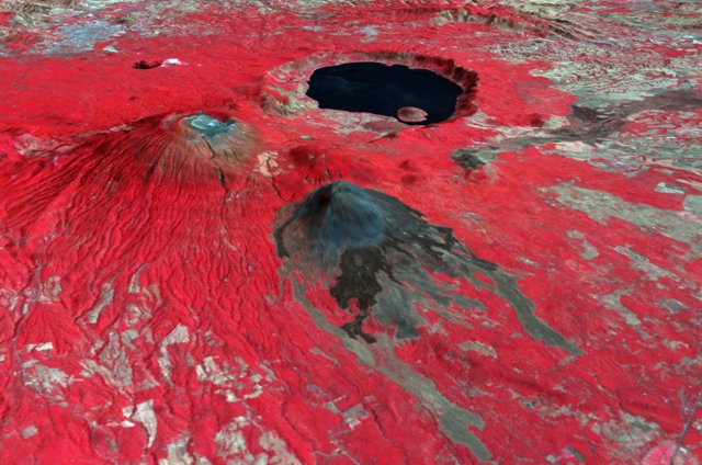 |
Figure 1. An ASTER image of Santa Ana from 2001 featured in one of several Earth Observatory reports. N is to the top left of the image and Santa Ana is the large, blunt-topped edifice closest to the left side of the image. In the color version of this image can be seen a tiny blue spot in the center of the inner-most crater?a crater lake (often called the lagoon). Behind Santa Ana is a large (7-km-diameter) lake inside the Coatepeque caldera. In the center is Izalco volcano, with dark-colored historical lava flows. Courtesy of NASA's Earth Observatory. |
SNET reported that a sudden eruption at Santa Ana took place around 0820 on 1 October 2005. They estimated that it produced an ash-and-gas plume to a height of ~ 10 km above the volcano. According to the Washington VAAC, ash was visible on satellite imagery at an altitude of ~ 14 km. The US Air Force Weather agency provided images of the plume (figure 2).
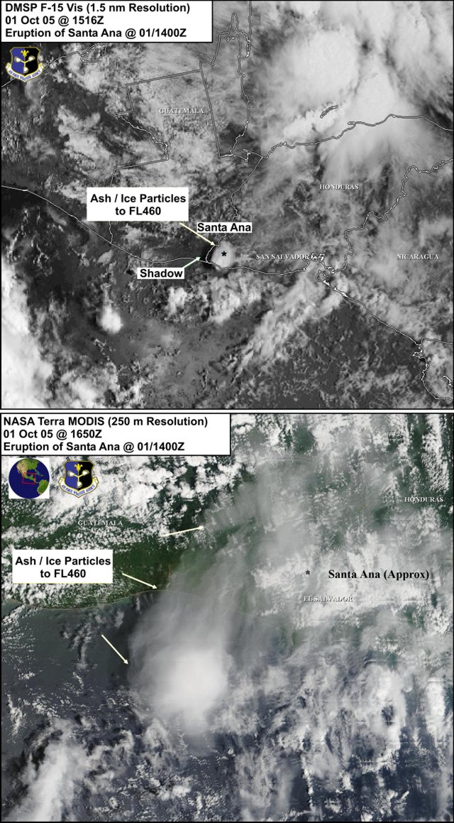 |
Figure 2. Two images of a Santa Ana eruptive plume on 1 October 2005. (top) The plume at 1516 UTC; (bottom) the plume at 1650 UTC. Note that the label 'FL 460,' stands for 'flight level 460,' which is equivalent to an altitude of 46,000 feet or 14 km. Courtesy of the US Air Force Weather Agency. |
Ash fell in towns W of the volcano, including in Naranjos, Nahuizalco, Juayúa, Ahuachapán (NW), and La Hachadura (at the border, ~ 40 km W, figure 3). SNET produced a graphic similar to an isopach map that showed near-source thicknesses provisionally to over 10 cm. The 10 cm isopach stretched ~ 5 km W; the 1 mm isopach, ~ 20 km W. The outermost isopach, presumably where measurable ash fell, was not closed; instead it was cut off along the Guatemalan border (~ 40 km to W of Santa Ana) and the caption said that ash would fall into valleys in Guatemala and to the sea. Volcanic blocks up to a meter in diameter fell as far as 2 km S of the volcano's crater. Lahar deposits were seen SE of the volcano. The alert level within a 4-km radius around the volcano's central crater was raised to Red, the highest level.
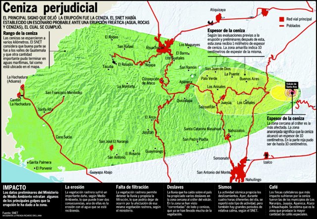 |
Figure 3. Graphic from SNET showing ashfall distribution from Santa Ana that appeared in the newspaper, La Prensa Grafica, following the 1 October eruption. N is upwards; Santa Ana lies ~ 40 km E of the Guatemalan border. This clearly transmitted the message that the ashfall was variable and W-directed over parts of El Salvador and neighboring Guatemala. The bottom of the graphic discussed the impact of the ash fall, including damage to specialty coffee farms. Credit: Ricardo Orellana, La Prensa Grafica. |
According to news reports, two people were killed by landslides (possibly caused by heavy rain in the area) in the town of Palo Campana, and thousands of residents near the volcano were evacuated. As many as 1,400 hectares of crops were damaged by ash (1 hectare = 10,000 m2). News also mentioned other processes such as a flood of boiling mud and water, and molten rocks, some the size of small automobiles, that will be discussed in later reports. A several-minute-long video from the LPG Television website appears as both a hyperlink and an active file on our website. In addition to numerous interviews with evacuees, it shows a host of features including what appear to be the swaths left by previously inflated mudflows passed down steep-sided valleys.
Prior to the eruption, no significant change in seismicity was observed. On 3 October, after the eruption, seismicity fluctuated and small explosions occasionally occurred. Earthquakes associated with explosions were recorded. In addition, there was a decrease in the amount of SO2 emitted from the volcano.
Strong degassing had been measured at the volcano since June 2004. An ash emission occurred on 16 June 2005, and a slight increase in seismicity and a significant increase in gas emission were measured from 27 July until at least 30 August. SNET also reported a significant increase in seismic activity at Santa Ana on the night of 27 August. A cluster of 17 volcano-tectonic earthquakes were recorded, with four located S of the volcano. Afterwards, continuous high-frequency tremor was recorded until at least 30 August. Observations made on 29 August revealed incandescent rocks in the fumarole field, effects attributed to hot gases heating the rocks to sufficient temperature to glow. A significant increase in SO2 emission was recorded, and gas-and-steam plumes rose 500-1,000 m above the volcano's crater. As a safety measure, access to the volcano's crater was restricted.
From 27 July until the eruption on 1 October, seismicity and gas emissions were above normal levels, and Santa Ana was at alert level yellow. During the first week of September, tremor continued to be recorded, and on 2 September a cluster of at least eight small earthquakes occurred, which were not felt by local residents. Gas plumes rose to ~ 500 m above the volcano, and the SO2 flux was over 1,000 metric tons per day during the first two weeks of September. Satellite imagery from 5 September showed a thermal anomaly.
Microseismicity increased significantly on 12 September. During a visit to the volcano on 8 September, larger areas of incandescence were visible at a field of fumaroles than during a visit on 29 August. Satellite imagery showed a thermal anomaly at the volcano on several days during the second week of September.
During 15-19 September gas plumes rose to ~ 500 m above the volcano, and the SO2 flux reached a maximum of 3,320 metric tons per day on 16 September. Microseismicity remained at relatively high levels. No significant changes were seen at the volcano's crater when observed on 19 September in comparison to 13 September. Intense degassing continued and the crater lake (lagoon) remained a dark coffee color. Incandescence was visible inside some cracks.
During a visit to the crater on 21 September, observers noted that the lagoon had become greener and small rock landslides occurred in the field of fumaroles. Gas plumes rose to ~ 1 km above the volcano on 26 September.
Following the eruption of 1 October, small explosions, degassing, and low-to-moderate seismicity occurred at Santa Ana during 5-11 October. Inclement weather prohibited ground and satellite observations, and sulfur-dioxide (SO2) measurements during much of the report period. During an aerial inspection of the volcano on 11 October, no changes were observed at the crater. Around 11 October, SO2 measurements were around 600-700 metric tons per day. The alert level within a 5-km radius around the volcano's central crater remained at Red.
Geological Summary. Santa Ana (also known as Ilamatepec), is a massive, dominantly andesitic-to-trachyandesitic stratovolcano in El Salvador immediately W of Coatepeque Caldera. Collapse during the late Pleistocene produced a voluminous debris avalanche that swept into the Pacific Ocean, forming the Acajutla Peninsula. Reconstruction of the volcano subsequently filled most of the collapse scarp. The broad summit is cut by several crescentic craters, and a series of vents and cones have formed along a 20-km-long fissure system that extends from near the town of Chalchuapa NNW of the volcano to the San Marcelino and Cerro la Olla cinder cones on the SE flank. Small to moderate explosive eruptions from both summit and flank vents have been documented since the 16th century. The San Marcelino cinder cone on the SE flank produced a lava flow in 1722 that traveled 13 km E.
Information Contacts: Servicio Nacional de Estudios Territoriales (SNET), Alameda Roosevelt y 55 Avenida Norte, Edificio Torre El Salvador, Quinta Planta, San Salvador, El Salvador (URL: http://www.snet.gob.sv); Washington Volcanic Ash Advisory Center (VAAC), NOAA/NESDIS Satellite Analysis Branch (SAB), 5200 Auth Road, Camp Springs, MD 20746, USA; Charles Holliday and Jenifer E. Piatt, U.S. Air Force Weather Agency (AFWA)/XOGM, Offutt Air Force Base, NE 68113, USA; NASA Earth Observatory (URL: http://earthobservatory.nasa.gov/NaturalHazards/); La Prensa Grafica and La Prensa Grafica Television, Final bulevar Santa Elena, frente a embajada de EUA, Antiguo Cuscatlán, La Libertad, San Salvador, El Salvador.