Report on Karthala (Comoros) — November 2005

Bulletin of the Global Volcanism Network, vol. 30, no. 11 (November 2005)
Managing Editor: Richard Wunderman.
Karthala (Comoros) Eruption on 24 November 2005; big evacuation and one fatality
Please cite this report as:
Global Volcanism Program, 2005. Report on Karthala (Comoros) (Wunderman, R., ed.). Bulletin of the Global Volcanism Network, 30:11. Smithsonian Institution. https://doi.org/10.5479/si.GVP.BGVN200511-233010
Karthala
Comoros
11.75°S, 43.38°E; summit elev. 2361 m
All times are local (unless otherwise noted)
The last eruption at Karthala occurred in April 2005 (BGVN 30:04); this report discusses the second large eruption of the year, on 24-25 November 2005. Karthala is a volcano with a lava lake and well-known for episodic outbursts. This report begins with imagery and maps, discusses satellite images of the 24-25 November ash plume, and then summarizes press and United Nations reports.
Satellite imagery. Elements of Karthala geography appear in figure 11. This and many other figures were produced by a United Nations consortium of public and private organizations, UNOSAT, which provides satellite imagery and geographic information to the humanitarian community. The islands capital, Moroni, lies on the coast directly W of the summit complex.
 |
Figure 11. A shaded relief map portrays the island of Grand Comore, with Karthala's summit complex (the cratered, highest-elevation area) on the S. Courtesy of UNOSAT and their partner organizations. |
Perspective on the eruption's impact can be seen on figure 12, containing images from both pre- and post-eruption time frames (13 July 2004 and 5 December 2005). Conspicuous new deposits at distance from the summit area were imaged on 5 December. Some new deposits resided in what appear as channels to the N of the craters, suggesting that freshly deposited tephra may have entered and followed the drainage systems: see channels on figure 12, heading NE. These tentative inferences by Bulletin editors were not discussed in available ground-based reports, so confirmation is lacking. No reports were yet available discussing the morphology or potential hazards of these new deposits.
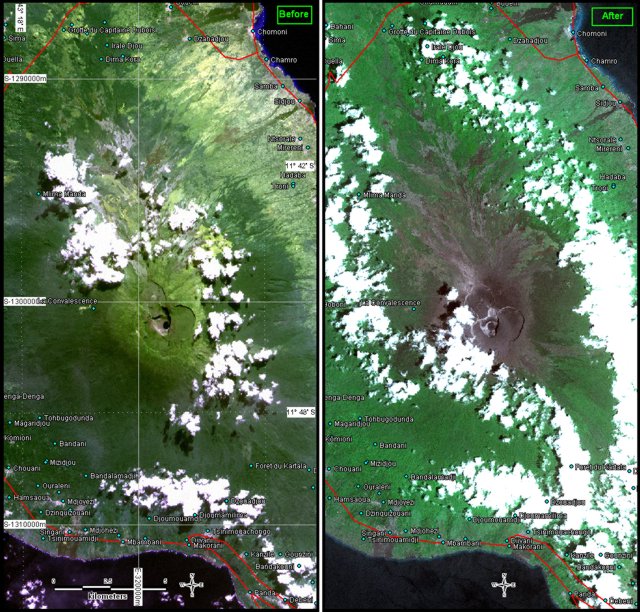 |
Figure 12. Karthala portrayed in two images (both with 10-m resolution; bands 321 + IR (RGBI)). Both images are at nearly, though not exactly, the same scales. The image at left is from before the eruption; taken by SPOT4 on 13 July 2004. The image at right is from after the eruption; taken by SPOT5 on 5 December 2005. Both images are partly masked by weather clouds. Large, clearly visible areas of new deposits appear in and around the summit crater area. Courtesy of UNOSAT and partner organizations. |
Ash clouds. Charles Holliday (US Air Force Weather Agency, AFWA) assessed the 25 November 2005 Karthala eruption plume using a NASA Terra MODIS image at 1010 local time (0710 UTC; figure 13). He measured the overall E-W extent of eruptive clouds as ~ 150 nautical miles (~ 280 km). The W margin of the brown clouds lie up to 30-50 km W and NW of the volcano. The light-colored clouds were blown SE, and they became far less optically dense towards the E where they extended over the vicinity of reef-fringed Mayotte Island. The image shows light-colored (nearly white) clouds above and centered SE of the visible brown clouds. Holliday interpreted this to represent a brown zone composed of dominantly ash with a higher lighter-colored zone of ash and ice particles. The tallest clouds reached FL 380 ('Flight Level 380,' a height of 38,000 feet or ~ 11.6 km altitude).
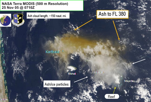 |
Figure 13. An image of the Karthala 25 November 2005 ash plume from NASA Terra MODIS. The image was centered over the Comoros islands, with the islands Mayotte, Anjouan, and Moheli labeled, and Grand Comore under ash clouds but the location of Karthala is indicated. For scale, the distance from Karthala to the S end of Mayotte island is ~240 km. The image shows AFWA interpretations of the ash cloud. Courtesy of Charles Holliday (AFWA). |
Fred Prata (CSIRO) processed both MODIS and AIRS images for the 25 November eruption (figures 14 and 15). Both instruments are part of NASA's Earth Observing System: MODIS stands for Moderate Resolution Imaging Spectro-Radiometer (flying onboard the Terra (EOS AM-1) satellite); AIRS stands for Atmospheric Infrared Sounder (which uses a grating spectrometer on the Aqua satellite).
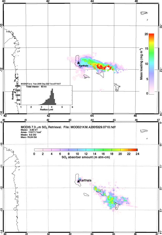 |
Figure 14. MODIS satellite images of the Karthala eruption plume on 25 November 2005 at 0710 UTC. The top image maps the computed atmospheric mass loading associated with the ash cloud; inset portrays the ash grain-size estimates in the same cloud. The bottom image maps the SO2 burden in the cloud, contoured in Dobson Units; the total mass of SO2 on this image was 2.85 kilotons. For distance scales, 1° of latitude (distance N-S) equates to ~111 km. Courtesy of Fred Prata, CSIRO. |
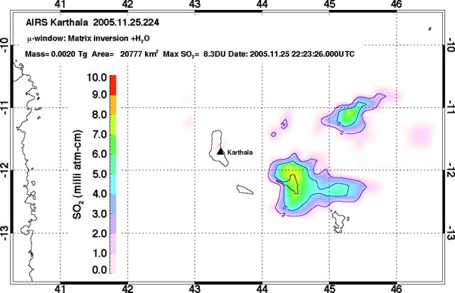 |
Figure 15. An AIRS image of the Karthala eruption's SO2 content for 25 November at about 2223 UTC. The measured mass total for SO2 was ~2.0 kilotons. Courtesy of Fred Prata, CSIRO. |
Prata used the MODIS image to estimate the 25 November eruption's mass loading. This resulted in an estimate of fine ash amounting to 83 kilotons (kt) in the grain-size ranges indicated. Analysis of SO2 from the MODIS data for 0710 on the 25th yielded 2.85 kt.
Prata also downloaded and processed the AIRS data available from 25 November but found only one good image (figure 12). Prata commented that the reason for the shortage of AIRS data stems from a compromise in instrument design, whereby when acquiring images at low latitudes, polar-orbiting satellites frequently lack sufficient overlap in their scanners to obtain full coverage. The one available satisfactory AIRS image, ~ 13 hours later than the MODIS image, showed a different plume configuration that included two separate zones of SO2 concentration rather than one. The mass of the SO2 measured by the AIRS instrument for the 25th was 2.0 kilotons. This value about the same as Prata obtained in a MODIS retrieval for the same 25 November eruption. In addition, the zones of elevated concentrations on both images stood in roughly the same place—except for the blob near 11°S detected by AIRS and not by MODIS.
Regarding his analysis of the 25 November Karthala eruption, Prata goes on to say that "assuming my fine ash loading of 83 kt is right and (big assumption now) this represents ~ 1% of the total erupted mass, then the volume of erupted ash would be ~ 0.006 km3. This suggests a VEI ~ 2. If the 1% estimate is robust (I've seen this quoted in Bill Rose's work) then the fine ash estimates from remote sensing may be quite helpful [in] assessing the 'size' of an eruption. Coupled with cloud-height estimates we may be moving towards some nice tools for volcanologists."
Prata further commented that he had hoped to image an algal bloom in the ocean where the Karthala ash had fallen. Recent work on ocean chemistry and biology (Boyd and others, 2000) point to iron enrichment as a means of ocean fertilization. As briefly discussed on the NASA Earth Observatory website, Anatahan plumes had recently been suggested to have triggered such blooms; however, with available remote-sensing data Prata was unable to confirm that the Karthala eruption triggered such a plume.
UN and related reports. The following appeared in a 28 November 2005 report of the United Nations Office for the Coordination of Humanitarian Affairs.
"The Karthala Volcano forms most of the landmass of Grande Comore (also called Ngazidja), the main island of the Union of the Comoros. The volcano is one of the largest volcanoes in activity in the world. Over the last two hundred years, it has erupted every eleven years on average. In April 2005, a volcanic eruption projected ashes and volcanic debris on the eastern part of the island, affecting as many as 40,000 people.
"[Karthala] had an eruption for the second time this year in the night of . . . 24 November, spilling ashes and smoke over the southeastern and southwestern parts of Grande Comore Island, and the Comoros capital, Moroni.
"During Friday 25, the projections of ashes and smoke receded. However, seismographic data collected by the Karthala Volcano Observatory has shown that the seismic activity is continuing. According to the observatory, a lava lake is in formation in the crater, as of yet confined within the crater. According to the local authorities, approximately 2,000 people fled from their villages in the region of Bambao in the central part of the island, and sought refuge in less exposed areas, such as Mitsamiouli, Mboudé, and Oichili."
"Concerns exist regarding the availability of potable water in the areas exposed to smoke and ashes. Preliminary results from the assessment indicate that as many as 118,000 persons living in 75 villages may be affected by the contamination of water tanks. A further assessment of the water tanks is underway to ascertain the exact scope of the needs. Concerns also exist regarding the impact of the pollution by volcanic debris on agriculture and livestock."
A 28 November news report by Agence France-Presse (AFP) also noted some of the above details, but added some new points. They said that the eruption had the effect of " . . .killing at least one infant, infiltrating homes, shops and offices and contaminating water in cisterns during the height of the dry season. 'We have two problems with water: one, we are in the dry season and two, the reserves in many private cisterns are now polluted,' minister of state for defense Abdu Madi Mari told AFP."
"He said cistern water supplies for about 120,000 residents mainly from rural villages near the volcano had been contaminated by the ash, which has also raised fears of respiratory ailments."
"Authorities on Grand Comore, the largest of the three semi-autonomous islands in the Comoros, had appealed for international assistance to help in distributing potable water to those in need, Mari said."
The AFP news report stated the eruption sent only "about 500 villagers fleeing from their homes in the shadow of the mountain." and said that despite continued tremor reported by the observatory, "almost all have now returned."
In a 9 December report the World Food Program estimated that the 24 November Karthala eruption affected 245,000 people. They briefly mentioned the issue of potentially contaminated drinking water but noted that, although minor eruptions continued, abundant rain in the weeks that followed helped reduce the potential water and air contamination problems. As noted above, no reports were found discussing problems from ash-choked drainages (lahars).
Geological Summary. The southernmost and largest of the two shield volcanoes forming Grand Comore Island (also known as Ngazidja Island), Karthala contains a 3 x 4 km summit caldera generated by repeated collapse. Elongated rift zones extend to the NNW and SE from the summit of the Hawaiian-style basaltic shield, which has an asymmetrical profile that is steeper to the S. The lower SE rift zone forms the Massif du Badjini, a peninsula at the SE tip of the island. Historical eruptions have modified the morphology of the compound, irregular summit caldera. More than twenty eruptions have been recorded since the 19th century from the summit caldera and vents on the N and S flanks. Many lava flows have reached the sea on both sides of the island. An 1860 lava flow from the summit caldera traveled ~13 km to the NW, reaching the W coast to the N of the capital city of Moroni.
Information Contacts: UNOSAT, United Nations Institute for Training and Research (UNITAR), Palais des Nations, CH - 1211 Geneva 10, Switzerland (URL: https://unitar.org/unosat/); Charles Holliday, U.S. Air Force Weather Agency (AFWA)/XOGM, Offutt Air Force Base, NE 68113, USA; Fred Prata, CSIRO Marine and Atmospheric Research, 107-121 Station Street, PMB 1, Aspendale, Victoria 3195, Australia; NASA Earth Observatory, NASA Goddard Space Flight Center, Code 900, Greenbelt, MD 20771, USA (URL: http://earthobservatory.nasa.gov/); MODIS Rapid Response Team, Goddard Space Flight Center, Code 923, Greenbelt, MD 20771, USA; Agence France-Presse (AFP); United Nations, Office for the Coordination of Humanitarian Affairs (OCHA) and the World Food Program (WFP) (URL: https://reliefweb.int/, http://www.wfp.org/).