Report on Ambae (Vanuatu) — December 2005
Bulletin of the Global Volcanism Network, vol. 30, no. 12 (December 2005)
Managing Editor: Richard Wunderman.
Ambae (Vanuatu) Landscape changes resulting from November 2005 eruption
Please cite this report as:
Global Volcanism Program, 2005. Report on Ambae (Vanuatu) (Wunderman, R., ed.). Bulletin of the Global Volcanism Network, 30:12. Smithsonian Institution. https://doi.org/10.5479/si.GVP.BGVN200512-257030
Ambae
Vanuatu
15.389°S, 167.835°E; summit elev. 1496 m
All times are local (unless otherwise noted)
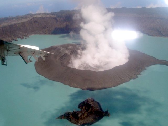
As previously reported (BGVN 30:11), a new eruption of Aoba began on 27 November 2005 when vapor plumes and ash columns were observed originating from Lake Voui, a crater lake at the summit. Activity continued into early January, building a large cinder cone in the west-central part of Lake Voui (figure 21). The new cone also contained its own crater lake.
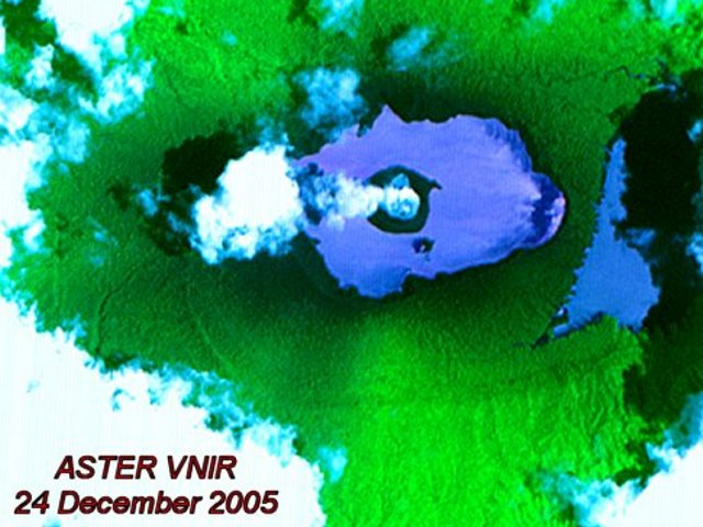
An image taken by ASTER's visible, near infra-red (VNIR) telescope on 24 December 2005 (UTC) showed the two larger caldera lakes, and steam escaping from an island in the center of Lake Voui (figure 22). The VNIR telescope has a resolution of ~ 15 m and operates in the spectral range 0.52-0.86 ?m.
During September through December 2005, infrared satellite data provided by Moderate Resolution Imaging Spectroradiometer (MODIS) and processed by the MODVOLC Hot-Spot algorithm at the Hawaii Institute of Geophysics and Planetology (HIGP) only observed a single-pixel thermal anomaly. It occurred at 0110 local time on 26 November 2005 ( the image was acquired at 1410 UTC on 25 November 2005). That was 1 day prior to reports of the eruption from ground-based observers, although the ground-based reports could easily have been delayed so it is not clear that the MODVOLC thermal anomaly was actually prior to ground based observations.
Matt Patrick noted that the anomaly is nicely centered in the caldera and is almost certainly volcanic ? no other anomalies occurred on the island in the previous 5 years.
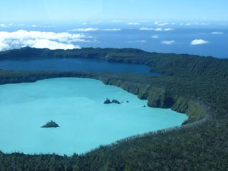
Geological Summary. The island of Ambae, also known as Aoba, is a massive 2,500 km3 basaltic shield that is the most voluminous volcano of the New Hebrides archipelago. A pronounced NE-SW-trending rift zone with numerous scoria cones gives the 16 x 38 km island an elongated form. A broad pyroclastic cone containing three crater lakes (Manaro Ngoru, Voui, and Manaro Lakua) is located at the summit within the youngest of at least two nested calderas, the largest of which is 6 km in diameter. That large central edifice is also called Manaro Voui or Lombenben volcano. Post-caldera explosive eruptions formed the summit craters about 360 years ago. A tuff cone was constructed within Lake Voui (or Vui) about 60 years later. The latest known flank eruption, about 300 years ago, destroyed the population of the Nduindui area near the western coast.
Information Contacts: Alain Bernard, IAVCEI Commission on Volcanic Lakes, Université Libre de Bruxelles, Brussels, Belgium (URL: http://www.ulb.ac.be/sciences/cvl/aoba/Ambae1.html); NASA Earth Observatory (URL: http://earthobservatory.nasa.gov/); Esline Garaebiti, Department of Geology, Mines and Water Resources, Port Vila, Vanuatu; Matt Patrick, University of Hawaii, Hawaii Institute of Geophysics and Planetology (HIGP) Thermal Alerts Team, 2525 Correa Road, Honolulu, HI 96822 (URL: http://modis.higp.hawaii.edu/).


