Report on Augustine (United States) — December 2005
Bulletin of the Global Volcanism Network, vol. 30, no. 12 (December 2005)
Managing Editor: Richard Wunderman.
Augustine (United States) Eruptions begin 11 January 2006 and eight outbursts occur by late January
Please cite this report as:
Global Volcanism Program, 2005. Report on Augustine (United States) (Wunderman, R., ed.). Bulletin of the Global Volcanism Network, 30:12. Smithsonian Institution. https://doi.org/10.5479/si.GVP.BGVN200512-313010
Augustine
United States
59.3626°N, 153.435°W; summit elev. 1218 m
All times are local (unless otherwise noted)
This report covers events from May 2005 through 26 January 2006. The first substantial ash-bearing eruption took place on 11 January; another one, on 17 January, rose to ~ 13.7 km. By late January there had been eight eruptions.
A National Oceanic and Atmospheric Administration (NOAA) message pointed out that life-threatening costly damages can occur to aircraft that fly through an eruption cloud. It added that the Federal Aviation Administration put NOAA's information to work, giving air traffic managers and controllers a heads-up to ensure airspace safety around the volcano as well as along the forecast trajectory of the ash plumes. Augustine eruptions had also automatically alerted the West Coast and Alaska Tsunami Warning Center. The geography of the Cook Inlet, where Augustine is located, is shown on figure 17.
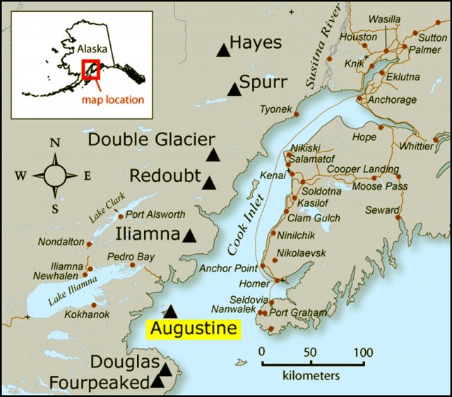 |
Figure 17. Map showing Augustine in its relation to nearby volcanoes, Cook Inlet, and surrounding communities. Courtesy of Janet Schaefer and AVO / Alaska Division of Geological & Geophysical Surveys. |
1985-89 crisis and eruption. The last major eruption of Augustine was in March 1986. Between mid-July and early August 1985, seismicity at Augustine began to increase. From then until late February 1986, recorded earthquakes averaged 12/day, with occasional short bursts of seismicity. On 17 February 1986 an explosion plume was observed over the volcano. Seismicity intensified after the end of February. On 27 March 1986 explosions sent eruption clouds into the stratosphere and generated pyroclastic flows that reached the sea. Ash was deposited over a wide area and international air traffic was disrupted. Explosive activity, ash plumes, and pyroclastic flows continued through August and September 1986, and Augustine steamed continuously through at least July 1989 (BGVN11:02-11:08, 13:07, 14:09).
Current eruption.This report is chiefly based on the continuing coverage of the Augustine eruption by the Alaska Volcano Observatory (AVO). The AVO website presents observations and remarkable photos documenting eruptive stages seen thus far.
Beginning in May 2005, there was a slow increase in the number of earthquakes under Augustine. The earthquakes were generally small (less than M 1) and concentrated roughly 1 km below the volcano's summit. These earthquakes slowly increased from 4-8 per day to 20-35 per day.
Data from a Global Positioning System (GPS) network on Augustine indicated that a slow, steady inflation of the volcano started in mid-summer 2005, continuing until the present. The GPS benchmark located nearest the summit moved a total of 2.5 cm. This motion is consistent with a source of inflation or pressure change centered under the volcano. This was the first such deformation detected at Augustine since measurements began just prior to the 1986 eruption.
On 29 November 2005 AVO raised the Concern Color Code from Green to Yellow after recording important long-term changes in seismicity and ground deformation consistent with renewed volcanic unrest. There were no indications that an eruption was imminent or certain. Seismicity remained at elevated levels during 30 November to 12 December 2005.
During 9-12 December, changes in the style of earthquake activity at the volcano were recorded, and there were reports of gas emissions and steaming. Seismic events on 9 and 11 December may have perturbed the hydrothermal system, initiating steam explosions. These seismic events were consistent with reports of steaming at the summit observed on 10 December, and reports of a distinct sulfur smell ("like from a sewer") in the air on the evening of 11 December at Nanwalek and Port Graham, ~ 80 km E of the volcano. Augustine remained at Concern Color Code Yellow. On 12 December a steam plume visible on video and satellite images extended 75 km SE (figure 18).
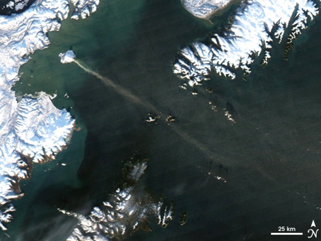 |
Figure 18. On 12 December 2005, a plume of volcanic gas and steam billowed from Augustine and spread ~ 80 km SE. This image was captured the same day by the Moderate Resolution Imaging Spectroradiometer (MODIS) onboard the Aqua satellite. In this image, the volcanic plume streams from the tiny, snow-capped volcanic island where Augustine is located and dissipates over the ocean. NASA image created by Jesse Allen, Earth Observatory, using data obtained courtesy of the MODIS Rapid Response team. |
During a 12 December flyover, AVO scientists saw profuse steaming from numerous summit fumaroles, emanating mainly from behind the 1986 lava dome. Several energetic fumaroles were also located 200 m down the SE flank. A gas-and-steam plume extended 75 km SE. Augustine remained at Concern Color Code Yellow. Reports during 14-23 December mentioned that residents E of the volcano smelled sulfur; and the reports noted intervals of elevated seismicity, and several small steam explosions.
A gas-measurement flight on 20 December detected SO2for the first time at Augustine since routine airborne measurements began in the early 1990s. Aerial observations and analysis of photography and video of the summit area indicated some deformation within the summit crater area. A crack or fissure was noted cutting the 1986 lava dome and extending to the SE (figure 19). Heavy steam from this feature, along with patches of bare ground, indicated an increase in the summit's heat output.
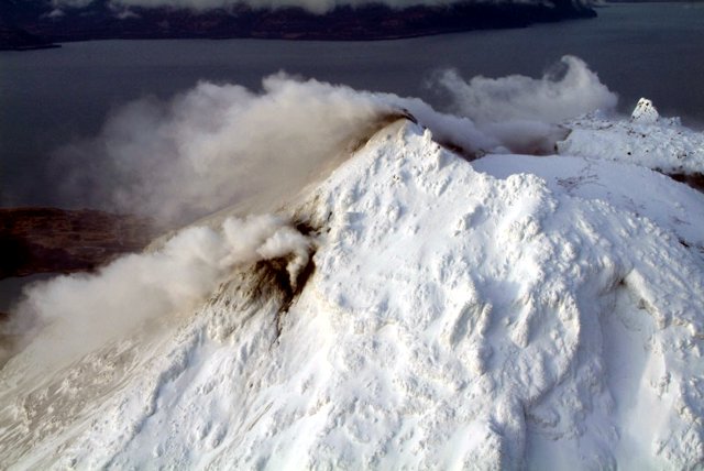 |
Figure 19. On 20 December 2005, Augustine emitted a steam jet from a SE-flank fissure and gave off steam from its summit area. Courtesy of C.F.Waythomas and AVO / USGS. |
Thermal imaging of the summit area took place on 22 December, using a helicopter-mounted FLIR (Forward Looking Infrared Radiometer). The imaging confirmed the presence of a new, high-temperature fumarole or gas vent located high on Augustine's S flank.
Seismicity decreased during the last week of December compared to the previous week; but steam and gas emissions continued. AVO scientists visited the volcano to install additional GPS receivers and deploy additional ash-collection devices. Observations continued to suggest that new magma was present. The level of seismicity was still well below that observed just prior to the 1986 eruption. Augustine remained at Concern Color Code Yellow.
During the first week of January 2006, seismicity increased slightly compared to the previous week. The volcano continued to steam vigorously from several summit fumaroles. AVO scientists visited the volcano to install additional seismic monitoring equipment, to deploy additional ash-collection devices, and to undertake helicopter-aided thermal surveys of the summit area. The high-temperature fumarole or gas vent on Augustine's upper S flank, previously reported on for 22 December, had cooled significantly, but elevated temperatures were detected at one summit fumarole imaged through the steam and gas. Although fumarole temperatures varied, there were no significant changes in the distribution of thermal features compared to the previous survey . A gas-measurement flight detected a significant increase in SO2compared to 20 December.
On 10 January 2006, AVO raised the Concern Color Code from Yellow to Orange. Earthquake activity beneath Augustine had increased markedly, indicating the heightened possibility of an explosive eruption within hours to days.
On 11 January 2006, AVO raised the Concern Color Code from Orange to Red after recording two discrete explosions at the summit at 0440 and 0513. Satellite data confirmed that an ash cloud was produced and, in collaboration with the National Weather Service (NWS), the top of the cloud was estimated at 9 km altitude. NWS and AVO tracked the ash plume, which detached from the vent and drifted to the N and E. By 0740, the ash cloud had traveled 40 km E and 50 km N. An ash-fall advisory was issued by the NWS at 0644. Seismicity decreased significantly after the explosions. During an 11 January afternoon overflight, AVO scientists observed a pure white steam cloud rising to about 3.5 km altitude and drifting NE. Little volcanic ash was observed on the island itself, but volcanic mudflows were evident on the E, S, and W sides of the volcano (figure 20). A brown haze in the air was observed over the central part of Cook Inlet.
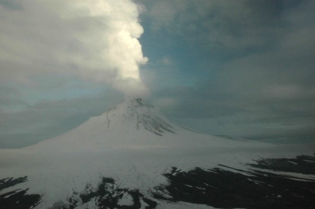 |
Figure 20. A W-looking view of Augustine from an observation flight made after the early morning steam emission on 11 January 2006. The image shows a snow-and-rock avalanche on the SW flank (to the left) and lahars visible as gray lobes on E and N flanks (to the right). Courtesy of Stephanie Prejean and AVO / USGS. |
After the eruption on 11 January, seismic activity declined. On 12 January 2006 the Level of Concern Color Code was lowered from Red to Orange.
Explosive eruptions on 13 and 14 January 2006 produced clouds of volcanic ash and flows of mud and rock fragments. A marked increase in seismicity early on 13 January preceded an eruption interval that began at around 0355 and ended around 0439. NWS subsequently reported ash heights of 10 km altitude. Other explosive events followed on 13 January, occurring at 0847, 1122, 1640 (figure 21) and 1858; and on 14 January at 0014 (figure 22). Each of these events produced ash plumes, mudflows, and pyroclastic flows on the island.
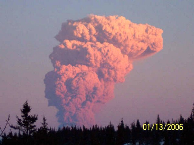 |
Figure 21. This photo of a large Augustine's eruption cloud was taken between about 1645 and 1700 on 13 January 2006 from Kokhanok on the SE side of Lake Iliamna, a spot ~ 80 km W of the volcano. Image courtesy of Gerald Andrew. |
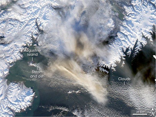 |
Figure 22. The Moderate Resolution Imaging Spectroradiometer (MODIS) flying onboard the Aqua satellite captured this image of an Augustine plume on 13 January 2006. Within a few ten's of kilometers of Augustine, a narrow steam and ash plume streams out and heads E over the ocean. Much broader zones of ash cloud dominate the middle of the image for over 100 km, both as an elongate zone to the ESE and more widely in a dispersed zone covering areas to the E and NE. In the colored image the ash clouds in the middle part of the image appear brown and white, and may well represent Augustine products in the atmosphere. NASA image created by Jesse Allen, Earth Observatory, using data obtained from the Goddard Earth Sciences DAAC (Distributed Active Archive Center). |
Ash clouds surpassed 9 km altitude, as reported by pilots and determined by radar data provided by the National Weather Service (NWS). Ash was carried to the E-SE and light ash falls were reported in communities of the southwestern Kenai Peninsula. According to preliminary assessment by Pavel Izbekov (Geophysical Institute, University of Alaska Fairbanks and AVO), the majority of ash particles in the 13 January seemed to be juvenile, though there are large variations in the morphology of ash particles as well as the composition of matrix glass. Enlargements of two ash grains appear in figures 23 and 24.
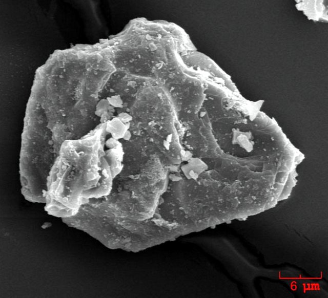 |
Figure 23. SEM image of an ash particle erupted by Augustine on 13 January 2006. This is an individual plagioclase crystal. The ash sample was collected in Homer by John Paskievitch of AVO. Image courtesy of Pavel Izbekov, the University of Alaska Fairbanks, Geophysical Institute and the AVO. |
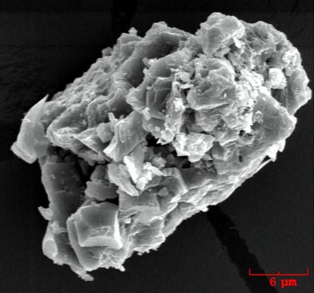 |
Figure 24. SEM image of an irregularly shaped ash particle erupted by Augustine on 13 January 2006. The ash sample was collected during the ashfall in Homer, Alaska by John Paskievitch, AVO. Image courtesy of Pavel Izbekov, the University of Alaska Fairbanks, Geophysical Institute and the AVO. |
On 14 January, AVO received reports from pilots of sulfurous odors and diffuse brown haze at flight altitudes when flying 400-500 km E of Augustine in SE Alaska (near Yakatat and Sitka). These diffuse ash-and-gas clouds were presumably from Augustine's explosive events on 13 January.
Seismicity declined in the 30 hours after the event early on 14 January, and AVO downgraded the color code from Red to Orange. The level of seismic activity at the volcano remained above background.
On 17 January 2006 an explosive eruption began at 0758 and ended at 0803. Seismic and pressure-sensor data indicated numerous small explosions, which could produce small amounts of low-level ash and could initiate small rock avalanches on the flanks. AVO raised the concern color from Orange to Red. A flight later on 17 January disclosed a brown ashy haze lingering over the island. Occasional views through the haze showed that most of the lava dome that formed following the 14 January eruption was destroyed in the explosion of 17 January. Observations made during a flight on the afternoon of 18 January 2006 indicated that the summit was steaming vigorously, consistent with the formation of a new lava dome. Evidence of explosive ejection of volcanic bombs included circular craters the size of large trucks seen on the NW flank. Block-and-ash-flow deposits with car-sized blocks produced by dome collapse covered parts of the SE flank. Surge deposits were observed on the NW flank. A white steam plume was observed rising to about 2,600 m altitude before it trailed off as a bluish haze to the E. Little to no ash appeared to be present in the plume.
After the eruption at 0758 on 17 January, seismicity diminished significantly and AVO lowered the color code from Red to Orange late on 18 January. By the morning of 19 January seismicity remained fixed at lower levels; it decreased further on 20 January but still stood above background. Periods of quiescence and low seismicity in the intervals between eruptive events are not unusual at Augustine, having occurred during the 1976 and 1986 eruptive episodes. By 25 January seismic activity at Augustine remained low but above background levels. During 23-26 January, satellite observations indicated the persistence of faint thermal anomalies. On 26 January steaming continued at the summit (figure 25).
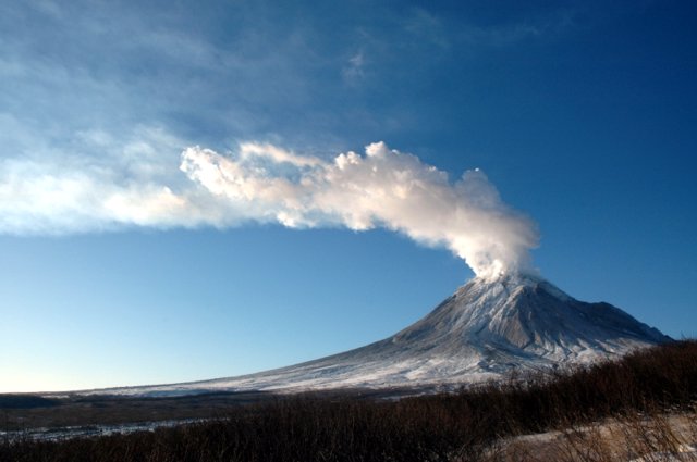 |
Figure 25. Augustine as seen from the NE on 24 January 2006 when a steam-and-gas plume drifted SSE. Image courtesy of M.L. Coombs and AVO/ USGS. |
Geological Summary. Augustine volcano, rising above Kamishak Bay in the southern Cook Inlet about 290 km SW of Anchorage, is the most active volcano of the eastern Aleutian arc. It consists of a complex of overlapping summit lava domes surrounded by an apron of volcaniclastic debris that descends to the sea on all sides. Few lava flows are exposed; the flanks consist mainly of debris-avalanche and pyroclastic-flow deposits formed by repeated collapse and regrowth of the summit. The latest episode of edifice collapse occurred during Augustine's large 1883 eruption; subsequent dome growth has restored the edifice to a height comparable to that prior to 1883. The oldest dated volcanic rocks on Augustine are more than 40,000 years old. At least 11 large debris avalanches have reached the sea during the past 1,800-2,000 years, and five major pumiceous tephras have been erupted during this interval. Recorded eruptions have typically consisted of explosive activity with emplacement of pumiceous pyroclastic-flow deposits followed by lava dome extrusion with associated block-and-ash flows.
Information Contacts: Alaska Volcano Observatory (AVO), a cooperative program of the U.S. Geological Survey, 4200 University Drive, Anchorage, AK 99508-4667, USA (URL: http://www.avo.alaska.edu/), Geophysical Institute, University of Alaska, PO Box 757320, Fairbanks, AK 99775-7320, USA, and Alaska Division of Geological & Geophysical Surveys, 794 University Ave., Suite 200, Fairbanks, AK 99709, USA; Jesse Allen, NASA Earth Observatory, Pavel E. Izbekov, Geophysical Institute, University of Alaska Fairbanks, 903 Koyukuk Drive, PO Box 757320 Fairbanks, AK 99775-7320, USA; Anchorage VAAC, Alaska Aviation Weather Unit, 6930 Sand Lake Road, Anchorage, AK 99502-1845,USA (URL: http://vaac.arh.noaa.gov/).