Report on Soufriere Hills (United Kingdom) — December 2005

Bulletin of the Global Volcanism Network, vol. 30, no. 12 (December 2005)
Managing Editor: Richard Wunderman.
Soufriere Hills (United Kingdom) Slow lava dome growth continued
Please cite this report as:
Global Volcanism Program, 2005. Report on Soufriere Hills (United Kingdom) (Wunderman, R., ed.). Bulletin of the Global Volcanism Network, 30:12. Smithsonian Institution. https://doi.org/10.5479/si.GVP.BGVN200512-360050
Soufriere Hills
United Kingdom
16.72°N, 62.18°W; summit elev. 915 m
All times are local (unless otherwise noted)
Activity at Soufrière Hills remained elevated during the latter half of 2005 (table 62). Since 5 September slow lava dome growth continued. During the week of 30 September through 7 October dome growth increased on the western side. On 26 October a pyroclastic flow with a runout of 2 km was reported around 2400. The pyroclastic flow was confined to the Tar River Valley.
Table 62. Soufrière Hills seismicity during 26 August to 30 December 2005. Courtesy of MVO.
| Date | Hybrid EQ's | Volcano-tectonic EQ's | Long-period EQ's |
| 26 Aug-02 Sep 2005 | 10 | 3 | 9 |
| 02 Sep-09 Sep 2005 | 5 | 6 | -- |
| 09 Sep-16 Sep 2005 | 13 | 70 | 5 |
| 16 Sep-23 Sep 2005 | 3 | 6 | 5 |
| 23 Sep-30 Sep 2005 | -- | 42 | 3 |
| 30 Sep-07 Oct 2005 | -- | 50 | 2 |
| 07 Oct-14 Oct 2005 | -- | 183 | -- |
| 14 Oct-21 Oct 2005 | 1 | 359 | 15 |
| 21 Oct-28 Oct 2005 | -- | 53 | 2 |
| 28 Oct-04 Nov 2005 | -- | 19 | 2 |
| 04 Nov-11 Nov 2005 | 2 | 14 | 6 |
| 11 Nov-18 Nov 2005 | -- | 3 | 8 |
| 18 Nov-25 Nov 2005 | 7 | 21 | 176 |
| 25 Nov-02 Dec 2005 | 2 | 1 | 93 |
| 09 Dec-16 Dec 2005 | -- | -- | 31 |
| 16 Dec-23 Dec 2005 | 2 | 1 | 40 |
| 23 Dec-30 Dec 2005 | 19 | 9 | 63 |
On 4 November dome growth on the southern flank was observed. The following week, growth was reported on the E, S, and SE flanks. Radar imaging of the dome indicated a dome volume of about 6.5 million cubic meters, suggesting a growth rate over the past two weeks of between 1.3 and 1.8 cubic meters per second with incandescence visible at night. Observations on the morning of 18 November indicated the dome continued to grow and sent rockfalls in all directions. A pyroclastic flow was observed in the Tar River valley on 15 November and reached to within 1km of the sea. The ash cloud associated with this event rose to ~2.1 km.
A pyroclastic flow was observed in the upper reaches of the Tar River valley on 22 November (figure 62). Minor venting of ash occurred, with one event taking place on the afternoon of 24 November, which produced an ash cloud that rose ~1 km above the summit (figure 63).
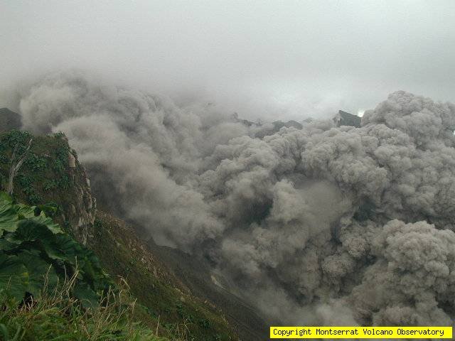 |
Figure 62. A photo showing a Soufriere Hills pyroclastic flow as seen from the NE on 22 November 2005. Photo courtesy of MVO. |
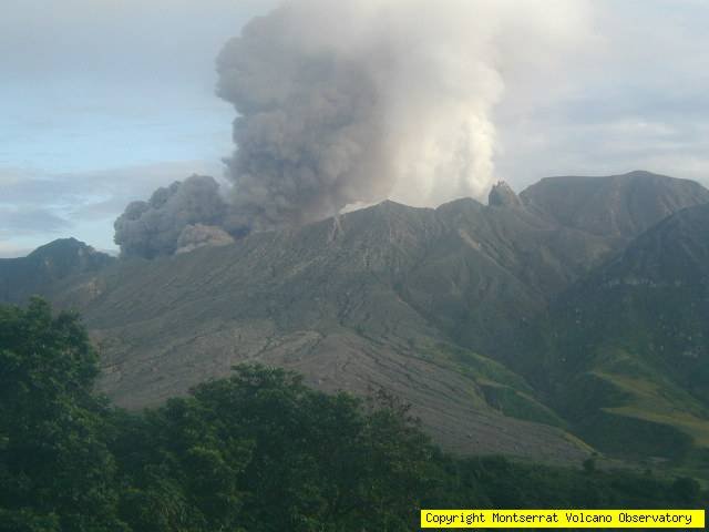 |
Figure 63. A photo showing a Soufriere Hills ash cloud as seen from the SE on 24 November 2005. Photo courtesy of MVO. |
During the month of December, dome growth continued on all flanks although more intense on the S and E flanks. More rockfalls and smaller pyroclastic flows have been reported with incandescence observed at night along the SE and E flanks.
Geological Summary. The complex, dominantly andesitic Soufrière Hills volcano occupies the southern half of the island of Montserrat. The summit area consists primarily of a series of lava domes emplaced along an ESE-trending zone. The volcano is flanked by Pleistocene complexes to the north and south. English's Crater, a 1-km-wide crater breached widely to the east by edifice collapse, was formed about 2000 years ago as a result of the youngest of several collapse events producing submarine debris-avalanche deposits. Block-and-ash flow and surge deposits associated with dome growth predominate in flank deposits, including those from an eruption that likely preceded the 1632 CE settlement of the island, allowing cultivation on recently devegetated land to near the summit. Non-eruptive seismic swarms occurred at 30-year intervals in the 20th century, but no historical eruptions were recorded until 1995. Long-term small-to-moderate ash eruptions beginning in that year were later accompanied by lava-dome growth and pyroclastic flows that forced evacuation of the southern half of the island and ultimately destroyed the capital city of Plymouth, causing major social and economic disruption.
Information Contacts: Montserrat Volcano Observatory (MVO), Fleming, Montserrat, West Indies (URL: http://www.mvo.ms/).